ADVENTURES AROUND THE WORLD
© Christopher Earls Brennen
Hike G1. Snowdon
- Hiking time: 10 hours
-
Estimated hiking distance: 7 miles

- Elevation gain: 2360 feet
- Topo Map: Snowdonia National Park Map
- Permit: None required
Characteristics
Dark age sailors, voyaging from Ireland toward their fellow Celts in Wales, were often guided by the snow-covered hills on the skyline that came to be called the Snowy Hills or, in Gaelic, ``Snaudune''. Later the name came to be applied to the highest of these peaks, the beautiful, windswept mountain we know as Snowdon, the highest point in Wales. Those from warmer climes, on hearing that the summit of Snowdon is but 3560ft above sea level, might be tempted to imagine it as little more than a hillock. They fail to take into account the fact that, at these high latitudes, the change in climate with elevation is much more dramatic than at lower latitudes. One can drive to the top of Mount Wilson in Southern California and, at 5500ft, hardly notice the change in climate from the basin below. On the other hand, conditions on the summit of Snowdon can be radically different than those just a few thousand feet below. This means that Snowdon is a more challenging climb than one might otherwise expect.
Snowdon is the highest among a group of mountains in the northwest corner of Wales, one of the most scenic and historic regions of the British Isles. It lies in the ancient kingdom of Gwynedd, also the name of the modern county in Wales. On the coast below the peaks stand the remains of some of the most storied castles in Europe. And Anglesey, the island just offshore, is equally historic. Many of the ancient Britons, driven westward by the Roman invasion, found refuge on Anglesey, known to the Romans as Mona. There, these people on the edge of prehistory not only sought safety but also the potential of the arable land of Anglesey. However, in the immediate aftermath of the invasion, the well-populated island represented such a threat to the Romans that the new governor, Suetonius, felt it necessary to organize a campaign to subdue it. Thus it was that, in the year 61AD, the Romans built a fleet of flat bottomed boats so that their infantry could cross the narrow Menai Straits separating Mona from the mainland. The Britons lined the shore to resist the invasion. They included women clad in black ``like the Furies with their hair hanging down and torches in their hands'' and Druids screaming encouragement and curses. Though initially shaken the Roman forces overran the island. As always, the history was written by the conquerors who were clearly doing their best to justify their uninvited ravages of a native population. Like many invaders before and since, the Romans proceeded to kill and destroy all they could find, leaving little to allow construct of the other side of the story.
In the centuries that followed the native Princes of Gwynedd, descendants of the ancient Britons, became the most powerful of the Welsh kings, benefitting from the natural protection of the mountains and from the fertile land of Anglesey. In the 1200s, Llywelyn the Great came closer to the creation of a unified Welsh nation than at any other time in history. The region was not overrun by the English until Edward I, following his accession in 1272, determined to extend his dominions and invaded Gwynedd, killing the last of the Llywelyns and destroying the remains of the Welsh resistence. To ensure the subjugation of the region, Edward built a series of formidable castles in strategic locations along the coast. These included the castles of Caernarfon, Beaumaris, Conwy and Harlech, that remain dominating features of the coast around Snowdonia. Edward also offered his first-born son to the Welsh as their new prince in a ceremony at Caernarfon castle that has been repeated by English monarchs ever since. Charles III was so designated by his mother Queen Elizabeth in a televised ceremony at Caernarfon some years ago. We should also note that the Welsh had some small, symbolic revenge about two centuries after Edward's invasion when Henry Tudor, with princely Welsh blood in his veins, defeated Richard III at the battle of Bosworth Field and was enthroned as the first of the Tudor Kings of England. The Welsh like to attribute the vitality of the great Tudor monarchs, Henry VIII and Elizabeth I, to their Welsh heritage, to say nothing of Elizabeth's red hair.
Again, Gwynedd faded into a backwater for many centuries. It achieved brief renown during the Victorian era when the demand for slate promoted the development of large quarries in Snowdonia, leaving livid scars on some of the foothills. There were also smaller-scale attempts to mine copper and other semi-precious metals but these brief efforts were quickly superceded in effectiveness by much richer veins in other lands. Tourism became the major industry in the early years of this century. Holyhead on the island of Anglesey became the major port of embarkation for Ireland and the construction of a railway through Snowdonia to Holyhead enhanced access to the region. Railways, especially of the narrow gauge type, had become a local speciality in order to transport slate and ore from the quarries and mines. As tourism increased, narrow gauge railways were also built as tourist attractions. So it was that a narrow gauge, cog railway was constructed from Llanberis at the foot of Snowdon to the summit. Built in 1896, this triumph of Victorian engineering is the only rack and pinion railway in Great Britain; the 5mi journey climbs an average gradient of 1 in 7. Today the Snowdon Mountain Railway continues to carry tourists to the summit during the summer months.
In 1951, Snowdonia became a National Park, a belated response by the British Government to the example set in the United States by Theodore Roosevelt about 40 years earlier. Today, it is heavily used throughout the year by a British public for whom it remains one of the few areas of relatively unspoilt wilderness in the British Isles. But, to the American visitor, there remain some intrusions that would hardly be tolerated in the US or Canada. For example, sheep roam freely throughout the Park, the ancient grazing rights of the local shepherds clearly unimpeded by the newly acquired status of the land. Sheep have grazed these mountains (and all others on these islands) for so many centuries that they have become a part of the natural order. One wonders how different the mountains would have looked without the sheep. Other human intrusions do not have the excuse of centuries of habit. Some of the lakes, including Llyn Llydaw, are used as reservoirs, that, in itself, is not necessarily objectionable. However the large diameter concrete pipe that carries water from Llyn Llydaw down toward the local towns and villages is an ugly eyesore, an unexcusable scar upon this land. No attempt was made to bury the pipe; instead it is suspended some feet above ground by regularly spaced concrete plinths that add to its ugliness.
Trailhead
Once, many years ago, I had driven quickly through Snowdonia on my way from Holyhead to London. I had seen enough through the rain and evening gloom to know that I wanted to return some day. And in the fall of 1992 I had an opportunity to revisit many of the places and people of my youth. In that year I travelled back to my academic roots for an all-too-brief sabbatical term in Oxford. Doreen joined me for the first four weeks and we delighted in this opportunity to revisit the city where we spent three years in relative poverty while I completed my graduate studies. We went to concerts and high table, delighting in the effortless elegance of the senior common rooms of Oxford colleges. We made many lazy tours through the Cotswolds, relishing marvellous meals in the gentle English country pubs. And we strolled through and around the city itself, exploring the many ancient walkways and distributaries of the Thames and the Cherwell. It was one of the best times Doreen and I ever had together and yet it was tinged with sadness for we knew we could not hide away there forever. And the four weeks came to an end too quickly.
Left alone for the remainder of the term I busied myself with lectures, academic discussions and visits to other friends in England. My host in Oxford, Terry Jones, had been a graduate student with me in the Engineering Department in the early sixties. I remember many hours when Terry and I had sat and talked over our cigarettes. I suppose we hoped that inspired theses would miraculously materialize out of thin air. He and his wife Lesley were at the same stage as Doreen and I, both with very small children. I had seen Terry very briefly on several occasions since those times. However, it was still surprising how easily we fell into the same pattern of chat, the same easy cameraderie. I have often wondered how it is that we sometimes find other people who fit naturally and easily into our personalities and vice-versa. Almost like two halves of a jigsaw puzzle. Not only do I experience pleasure in the company of people like Terry but I must also admit to a certain analytical fascination. Perhaps if I studied such people sufficiently closely I would find myself in sympathetic sillouette. There seemed to me to be many parallels between Terry's life and my own since our days as graduate students. On the mundane side we had both shed the nicotine devil and had both come to enjoy hiking and solitude. At a deeper level, I could now see in Terry some of the mindless drive that I knew lay within me. But more importantly, I came again to enjoy his company. On several occasions, I had mentioned to him my desire to see Snowdonia and when he suggested that we go hiking there together I eagerly agreed.
So it was that early on a Saturday morning in November, Terry and I set off from Oxford for Snowdonia. The drive is quite uninteresting until one begins to enter the hills of northwestern Wales. Despite the fact that it is the main road to the Irish ferry at Holyhead, the road narrows from a motorway to a winding, two-lane country road by the time it reaches the land of the Welsh at Llangollen. Not only does the quality of the highway decline significantly but, simultaneously, the names on the signposts become strangely foreign. Instructions to motorists are bilingual. And yet the faces of the people and the atmosphere of the villages were oddly familiar to me for they reminded me of my native Ireland, not really surprising considering the common Celtic heritage. Even more specifically one could sense the stern cultural overlay of non-conformism similar to my native Ulster, a feature that gives the villages an iconoclastic bleakness. My eyes see this as unattractive but this judgement is overridden by my affection for the culture and the people.
The road winds through increasingly wooded and hilly terrain and then drops into a very beautiful, forested glen at Betws-y-Coed, a favorite holiday base for outdoorsmen since the turn of the century. The substantial annual rainfall feeds marvellous rivers and waterfalls, making this area a favorite venue for kayakers and canoeists. Indeed, as we passed through the next village, Capel Curig, it was clear that a substantial kayaking event was being held there.
After Capel Curig, the road climbs toward the mountains around Snowdon and the land becomes bleaker. The trees disappear and the landscape takes on that aspect common to most land above 1000ft in the British Isles. Valleys were covered with heather whose accumulation over many centuries has blocked the easy runoff of rainwater forming many small, cold lakes. The uplands are rocky but have, to some degree, been rounded by glaciation. Only the hardiest grasses seemed to survive on these rugged hills, lashed for most of the year by rain and gales. At higher altitudes even the grasses have difficulty surviving and lichens and mosses become more prevalent.
We drove to the gap through the mountains that is called the pass of Llanberis or Pen-y-Pass, 53o4.83'N 4o1.24'W and elevation 1205ft. A small group of dark, stone houses on the saddle at the top of the pass service the needs of the stream of hikers who stop here. One of these structures is a well-known youth hostel. We stopped in the crowded parking lot and were immediately approached by a group of very demanding sheep. It appeared to us as though they would attempt to eat just about anything including boots! It required quite vigorous protestation to hold these scavengers at bay. Eventually, however, we organized our equipment and food, strapped up our daypacks and were ready for the trail.
Hike
Very crudely, the summit of Snowdon can be visualized as the confluence of six ridges or spines running north, northwest, southwest, south, southeast and northeast from the peak. Glaciation during the ice ages scooped out great amphitheatres between many of these spines, leaving precipitous cliffs on the sides of the ridges. The spine to the north is the broadest and least steep and it is up this route that the railway runs on its way from Llanberis to the summit. Another popular trail skirts the great amphitheatre between the northwestern and southwestern ridges; it then climbs the scree to the top of the northwestern ridge and thence to the summit. Actually two parallel trails called the Pyg Track and the Miner's Track follow this route, the former high above the latter. They both begin at the trailhead at Pen-y-Pass, where the road from Llanberis to Capel Curig reaches a saddle summit at an elevation of 1200ft. It was this route that we followed to the top, taking the Pyg Track during the ascent and the Miner's Track for the descent.
The Pyg Track climbs along the north side of the ridge that runs due west from Pen-y-pass to the summit of Snowdon. Quickly our view north toward Llanberis and the sea opened up and we paused several times to admire the scenery. It had rained the day before (and would rain heavily the next day) so we felt very lucky that to have been spared a soaking. Better still, our view was relatively unimpeded; only the very top of the mountain was hidden by the clouds.
After about half a mile the trail reached a notch on the crest of the ridge and suddenly revealed a marvellous view to the south. Below us shimmered the lake known as Llyn Llydaw, lying in the bottom of a large bowl scooped out by glaciation. The other side of this bowl consisted of quite dramatic cliffs forming the northern side of the ridge known as Y Lliwedd. At this saddle one can choose to continue directly up the spine of the ridge, a very challenging climb along the jagged rocks known as Crib Goch. We chose to continue up the easier trail that climbed gradually up the south side of the ridge. Above us we could occasionally catch sight of more intrepid climbers negotiating the rocky obstacles on the ridge. Below, others were hiking up the other trail, the Miner's Track that starts along the shore of Llyn Llydaw but then climbs to meet the Pyg Track that we were following. As we climbed the trail eventually graduated from the large glaciated bowl into a much smaller and steeper amphitheatre containing the circular lake called Glaslyn. A ribbon waterfall hundreds of feet high fed the lake. At this point the trail became considerably steeper and rougher as it climbed the steep scree in one corner of this small amphitheater. Gradually we climbed into the cloud cover and the temperature fell quite dramatically. Then, quite suddenly, we reached the railway line at 53o4.36'N 4o4.78'W and elevation 3170ft and turned south to follow the railway for the last quarter mile to the summit. Here in the clouds, the temperature was below freezing and a thick frost covered all the rock surfaces. The frost had a quite unusual shape. The crystalline ice-stalagmites seemed formed by the combined effects of a temperature wavering below and above freezing, the continuous supply of moisture in the air and sculpturing by the wind. The crystals adorned the rocks and the rails and, with the mist, lent our surroundings a slightly surrealistic aura.
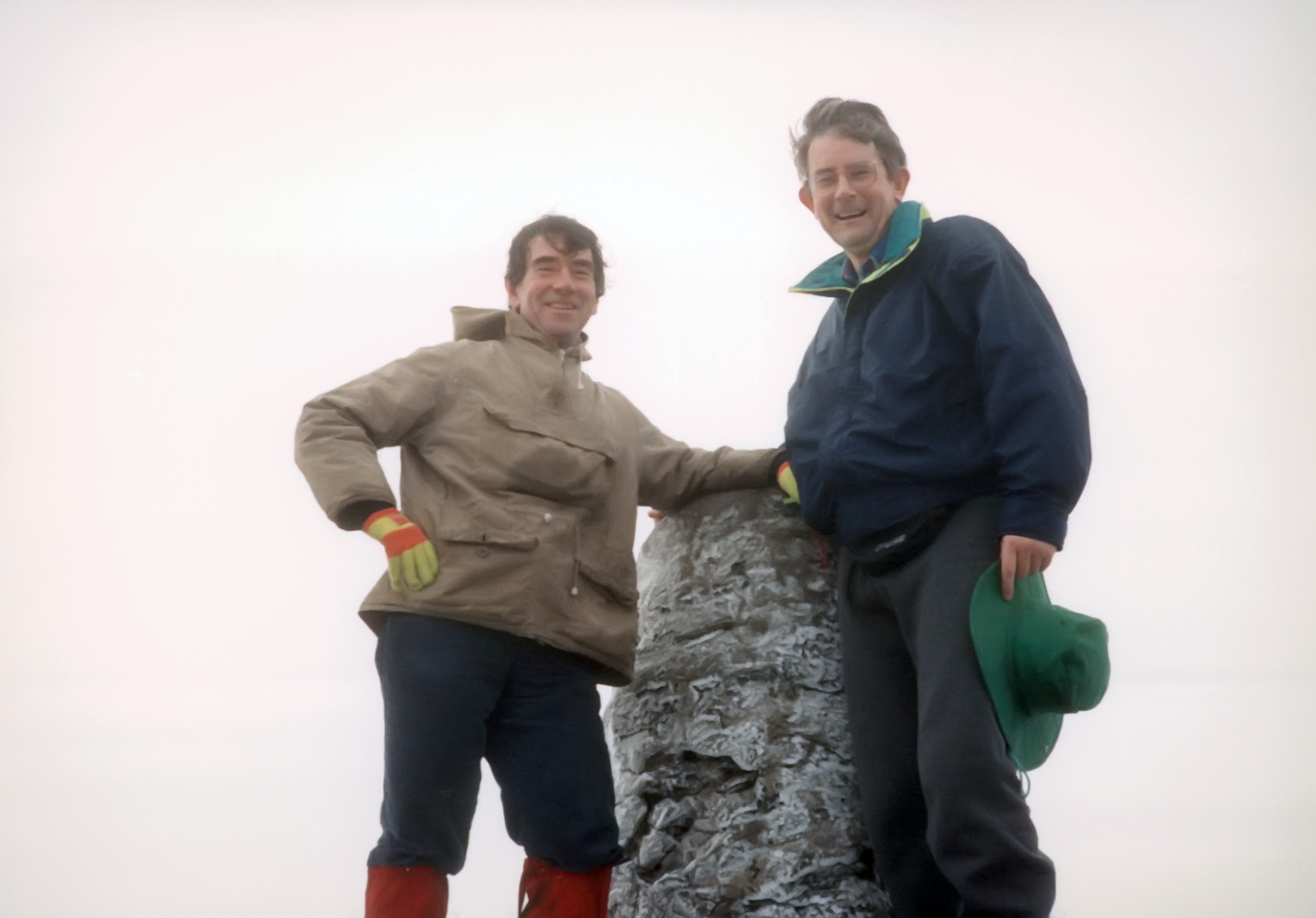
We paused briefly at the large, vertical lith marking the trail junction before walking the last few hundred yards along the railway to the summit. There, the station building was boarded up for the winter, but still served to provide some shelter from the freezing wind. About thirty feet above the station a substantial cairn marks the summit of Snowdon at 53o4.11'N 4o4.57'W and elevation 3560ft. We imposed on one of the many nearby hikers to take our photograph on top of the cairn. People were standing and waiting in the hope that a break in the clouds would allow a momentary view from the summit. One could detect that the top of the clouds were not far above us for hints of blue sky could be glimpsed. And we knew that the bottom was not far below us. But we waited in vain for that break in the clouds.
| |
|---|---|
| At the summit of Snowden with Terry Jones |
It was too cold to lunch at the summit so we soon decided to begin our return journey. Retracing our steps down along the railway line we had no difficulty in locating the monolith marking the trail junction and so began the steep descent into the amphitheatre of Glaslyn. Where the two parallel trails meet we left the Pyg Track and followed the Miner's Track down the scree slope to the shore of Glaslyn itself. Here the remains of a miner's barracks provides an attractive novelty. Perhaps the purist would see these ruins as an eyesore equal to the concrete pipeline. But to the average arbiter its age and the fact that it was constructed of native stone makes it quite unobjectionable. Terry and I ate our lunch seated on the stone steps of this antiquity. But we did not dally long for the day was ebbing. From Glaslyn the Miner's Track follows the shores of that lake and of the lower Llyn Llydaw. A broad track it passes other ruined buildings from the mining era including the remains of the ore-crushing mill of the Britannia Copper Mine. Near the end of Llyn Llydaw the trail crosses the lake by way of a causeway that was originally built so that copper could be more readily transported down the mountain. Finally we contoured along the ridge back to the Pen-y-pass car park.
As the late afternoon gloom settled over the mountains and people and
sheep gathered themselves for the coming cold, we resigned ourselves for
the long drive back to Oxford. The gloom seemed to summon silence
and was bolstered by the thought that that was that.
On Snowdon we had chatted as we almost always do when we are together. Yet
I remember little of the subjects we covered. What I will
remember is that sense of easy and enjoyable companionship that
characterized all our times together. Mountains help bring those feelings
into sharper focus. They provide perspective not only for the surrounding
landscape but also for the landscape of our emotions, relationships and
desires.
But they do not make it any easier to put those feelings into words.
Last updated 7/30/99.
Christopher E. Brennen