ADVENTURES AROUND THE WORLD
© Christopher Earls Brennen
Hike D3. Sambulbong
- Hiking time: 4 hours
-
Estimated hiking distance: 5.8 miles

- Elevation gain: 2135 feet
- Difficulties: None
- Permit: None
Characteristics
Sambulbong is a mountain in South Korea in Gyeryongsan National Park closeby the city of Daejon. The Gyeryongsan National Park is a beautiful area of rugged peaks, streams and valleys that include a number of popular trails. In April 1997, S-J. Lee and I climbed two of the highest peaks, Sambulbong and Gwaneumbong, and, in the process, visited Eunseon waterfall and the lovely Donghaksa Temple.
Trailhead
The hike begins at the main entrance to Gyeryongsan National Park at an elevation of 522 ft where there is a collection of shops and restaurants. The bus-ride from Daejon to the Donghaksa Bus Terminal in this tourist area takes about 40 min. From there it is just a short walk to the trailhead.
Hike
There are multiple well-marked trails in Gyeryongsan National Park. The one we took (and perhaps the most popular) is called the Donghaksa Course 2. It is a hike of 5.9 mi with spectacular views and visits to the two peaks, Sambulbong and Gwaneumbong.
From the trailhead at 524 ft elevation, the route proceeds up a gentle incline alongside a stream and on a trail paved with large rocks. At 1.1 mi from the start you will come to a trail junction at 735 ft elevation. About 150 yds further on along the left fork is the Donghaksa (or East-Crane) Temple. The temple name derives from a rock of the shape of a crane which is a short way east of the temple. The crane or rock supposedly connects this world and Buddha's world.
Returning and taking the right fork at the junction you access the trail that climbs steeply in a northeasterly direction toward the ridge-top where you come to a trail junction on the ridge at 1946 ft elevation and about 2.0 mi from the start. Turning left, you arrive at the Brother and Sister Pagodas (or Nammaetap Pagoda) about 150 yds from the junction. It is only about a 15-20 minute hike (or 0.2 mi) from Nammaetap Pagoda to the summit of Sambulbong (or Sambul Peak), 36.36146oN 127.21051oE and an elevation of 2559 ft a distance of 2.3 mi from the start. The last leg is a climb up a staircase ladder. The name, Samsulbong, translates as the Three Buddhas Peak (three Buddhas usually sit in the main building of a Buddhist temple.) The view from the summit is quite spectacular.
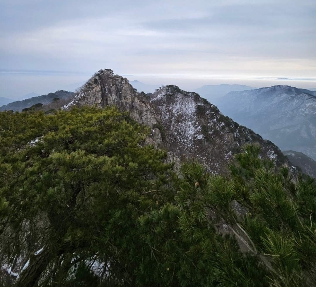
|
|---|
| Sambulbong seen from Gwaneumbong. |
Continuing on along the ridgeline beyond Sambulbong the trail crosses some narrow ledges with rails. It takes about an hour to reach Gwaneumbong, the second peak on this hike at 2530 ft and 3.3 mi from the start. There are breathtaking views from Gwaneumbong and it is a great place to sit on a giant rock on top of the mountain to rest. Gwaneumbong stands for the Avalokitesvara-peak and is named for the man who sits next to Buddha and takes care of people's wishes in Buddhism.
On the descent down from Gwaneumbong you walk alongside a stream of small waterfalls before arriving at the observation deck for the beautiful Eunseon waterfall, about 150 ft in height. This at 36.35222oN 127.20833oE and an elevation of 1330 ft.
Continuing the descent and just before you come to the 750 ft elevation junction (about 4.8 mi from the start) you will pass the lovely Donghaksa Temple on your left. The Donghaksa Temple is known for housing and teaching many female Buddhist monks. The grounds consist of multiple buildings with stone pagodas tucked between the buildings.
From the 750 ft junction it is a pleasant stroll down the verdant valley back to the trailhead 5.9 mi from the start.
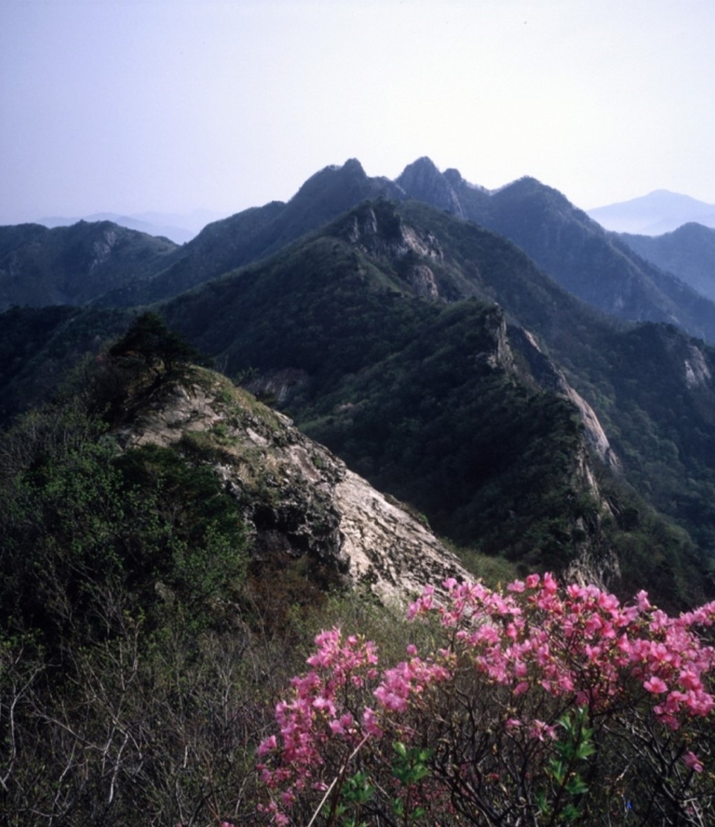
|
|---|
| Gwaneumbong in spring with Jindallae flowers. |
Last updated 1/27/03.
Christopher E. Brennen