ADVENTURES AROUND THE WORLD
© Christopher Earls Brennen
Hike G2. Welsh Mountain Railways

Characteristics
The steep hills and narrow trails of north Wales led to the development of narrow gauge railways that could allow the exploitation of the quarried and mined riches of that country. One of the principal riches was the specially striated rock that could, quite remarkably, be split into slates that, for a century or more became the developed world's prefered roofing material. Thus did Welsh slate find its way onto roofs around the world. In later time as other roofing materials became developed, the quaint little railways that carried the slate down from the mountains lost their initial purpose but became a primary tourist attraction. Here we describe visits to two of the best known of the narrow gauge railways in north Wales, namely the Snowdon Mountain Railway and the Blaenau-Ffestiniog railway.
Snowdon Mountain Railway
The Snowdon Mountain Railway is a narrow gauge (2ft, 7.5in) rack and pinion railway that climbs for 4.7 miles from the coastal town of Llanberis in north Wales to the 3560 ft summit of Snowdon, the highest peak in Wales. Built in 1894-6, the tourist attraction has flourished in spite of an opening day accident in which the train derailed and the locomotive fell down the mountain. Other accidents required the initiation of precautions including a the limitaton of one carriage pushed by the locomotive. It is a single track line with a number of passing loops. The average gradient is 12.7% with the steepest being 18.2%.
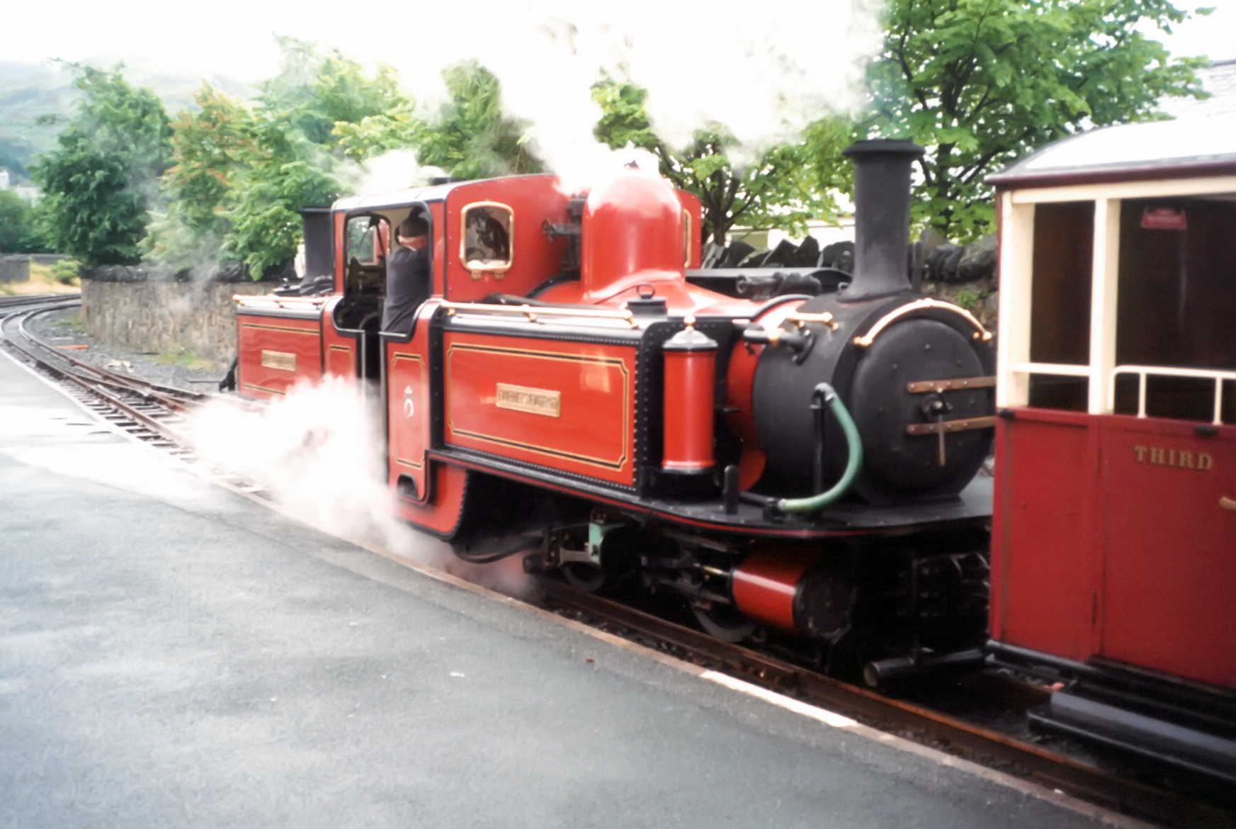
.JPG)
|
|---|
| Snowdon Mountain Railway engine |
The route includes seven stops begining with the terminus at Llanberis, at 53.1163oN 4.1195oE and an altitude of 353 ft. This is close to the center of Llanberis. From there the train passes the now-closed halt called Waterfall at 53.1111oN 4.1267oE (altitude 580 ft) built to allow early passengers to view the nearby waterfalls. The first operational stop is Hebron station (53.1046oN 4.1179oW, altitude 1069 ft), first built in 1797 and named after a nearby Calvinistic Methodist chapel now in ruins. Halfway up at 53.0956oN 4.0960oW and altitude 1641 ft there is a stop where the line comes close to the Halfway House cafe on a nearby trail. Further up the Rocky Valley Halt at 53.0889oN 4.0838oW and altitude 2330 ft consists of a narrow platform under a rocky outcrop. Just beyond this the line runs for about a half-mile along a narrow exposed ridge before stopping at the Clogwyn Halt at 53.0841oN 4.0803oW and an altitude of 2556 ft. Here there are great views (clouds permitting) looking down at the Llanberis Pass. Finally the train reaches the Summit Station at 53.0680oN 4.0783oW and an altitude of 3493 ft where there are services and shelter. The summit itself is just a few yards away and 68 ft higher.
I confess that on both occasions that I have ascended Snowdon, once by foot and once by train (in July 2001), the summit was cloaked in cloud and the views at the top were minimal though not bad at lower elevations. If possible choose a day when the top is not so obscured.
The journey time to Snowdon Summit is approximately 60 minutes and passengers have a 30 minute stop-over at the summit and the summit visitor centre. The round trip to the summit and back is approximately 2.5 hours in total, including the 30 minute stop-over.
Blaenau-Ffestiniog Railway
The Blaenau-Ffestiniog Railway is a narrow gauge (1ft 11.5in) mountain railway first built in the 1830s to transport slate from the slate mines near the mountain village of Blaenau-Ffestiniog Railway down to the Welsh port of Porthmadog some 13.5 mi away and 700 ft lower in altitude. Originally the line was built to allow loaded slate trains to make a controlled descent under gravity and to have empty trains hauled back up by horses. Because of the slowness of this arrangement and the increase in their business, steam locomotives were introduced in the 1860s to improve the efficiency of the operation and shortly thereafter passenger services were initiated. The loaded slate trains continued to operate by gravity until the end of passenger services in 1939. Today the primary use is as a tourist attraction.
|
|---|
| Ffestiniog Railway engine |
The route of the Blaenau-Ffestiniog Railway has seen significant restorations and re-routings since its inception, most recently the deviation required by the construction of the Ffestiniog hydro-electric power/pumping station and its reservoir, Llyn Ystradau. At the southern end this required the construction of a spiral loop, the only one of its kind on British railways. This was built just north of Dduallt station and involved the only section of descending railway just north of the spiral loop where the elevation change is 35 ft. North of this the line runs along the shore of the reservoir. We describe below only the current configuration of the stations.

|
|---|
| The old line just south of the Llyn Ystradau deviation and the new route in the foreground |
Descending from Blaenau Ffestiniog, there are four main stops at Tanygrisiau, Tan-y-Bwlch, Penrhyn and Minffordd before the end at Porthmadog though there are several request stops at a variety of points along the line. The first stop is the Tanygrisiau station at 52.98580oN 3.96303oW and elevation 640 ft ; this is just about 1.5 mi and 5 minutes from Blaenau Ffestiniog. Shortly after Tanygrisiau you pass along the shore of Llyn Ystradau lake or reservoir formed by the dam that is part of the Ffestiniog hydro-electric power/pumping station. Here you are traveling along the deviation required by that project. Some distance beyond the lake as you approach Dduallt halt you come to the spiral loop where the line circles above the Dduallt station and descends to pass under its own route at 52.9591oN 3.9692oW and an altitude of 540 ft. Dduallt halt is at 52.9602oN 3.9686oW and an altitude of 540 ft and a distance of about 4 mi from Blaenau Ffestiniog.
There follows a stretch of beautiful wooded scenery before you come to Tan-y-Bwlch station about 6.5 mi or 30 minutes from Blaenau Ffestiniog at 52.9545oN 4.0113oW and elevation of 434 ft. This is the main location for trains in opposite directions to pass each other. When the station opened in 1873 it soon became a popular place for passengers to alight, to stroll in the surrounding woodlands. Before the Second World War the station, unusually, was managed by a woman. Bessie Jones dressed in traditional Welsh costume. She sold tea and postcards to passengers. She herself was the subject of many picture postcards.
When I came this way in 2001 I climbed aboard the train in Blaenau-Ffestiniog and rode down to Tan-y-Bwlch where I quickly changed trains and returned to Blaenau-Ffestiniog. The present timetable does not appear to allow for such an itinerary. My round trip back then was a little over 60 minutes but a better choice would be to go all the way to Porthmadog and back, a trip which the current timetables say can be done in 2 hours 45 minutes.
From Tan-y-Bwlch the train to Porthmadog continues to descend through beautiful wooded mountain scenery before arriving at Penrhyn station at 52.9351oN 4.0647oW and elevation of
160 ft. Penrhyn is about 10.4 mi and 45 minutes from Blaenau Ffestiniog. As the route flattens the train comes to Minffordd station at 52.9259oN 4.0840oW and elevation of 85 ft. This is about 11.4 mi and 55 minutes from Blaenau Ffestiniog. Finally you cross along the Cob, a man made embankment before arriving at the
Porthmadog Harbour terminus. This is at 52.9239oN 4.1270oW and about 13.5 mi and 70 minutes from Blaenau Ffestiniog.
Last updated 9/1/00.
Christopher E. Brennen