ADVENTURES AROUND THE WORLD
© Christopher Earls Brennen
Hike F7. Errigal
- Hiking time: 3 hours
-
Estimated hiking distance: 3 miles

- Elevation gain: 1630 feet
- Topo Map: Sheet 1 (North Donegal), 1:126720 Series, Ordnance Survey of Ireland
- Permit: None required
Characteristics
Falcarragh. The name of this desolate little village in the extreme northwest corner of Ireland conjures up a host of haunting memories for me, memories of a bleak rainstreaked landscape, of ancient Celtic tragedies and of a strange and impoverished people. When I was young my father and mother, always adventurous people, would arrange to rent a cottage on the edge of one of the deep inlets along this convoluted coast. We would load up one of our two cars with every possible kitchen and bedroom need and set off west from our home in Derry for the wilds of County Donegal. In those days there were many formalities to follow at the international border just west of the city of Derry. Thereafter, as the landscape bleakened and the roads became rough and narrow, we would travel beyond the reach of English hegemony into sparsely populated Donegal, ``Dun na nGall'' or the ``Fort of the Foreigners'' (the name derives from the fact that the Vikings founded the town of Donegal).
But, of course, there was a substantial intermediate zone in which English rule held some sway and the market towns relied for their prosperity on the economic giant to the east. Because of those commercial pressures, English had long ago supplanted Gaelic as the mother tongue. Only the extreme northwest corner of Donegal, the area around Falcarragh, Gweedore, Gortahork and including Tory Island, was isolated enough to avoid those pressures. There to this day, Gaelic is still the native language of about 30,000 inhabitants. The region is known as the ``Gaeltacht'' and its boundary represents a distinct border within Ireland. If you drive from Dunfanaghy to Falcarragh, you will pass a road sign, ``An Gaeltacht'', marking the boundary of this area.
None of the holiday cottages were in the Gaeltacht for that would have been too strange, too foreign. The closest we came was a very rustic cottage near Dunfanaghy, a town remembered for its workhouse, one of those terrible places that were the only refuge for the starving and destitute created by the Great Famine in the 1840s. Indeed the famine hit the Gaeltacht particularly hard because the poverty of that region left little margin between subsistence and destitution. So at the height of the famine 600 starving and dying people were packed into the small workhouse buildings. Today the workhouse is a tourist attraction that tells the wrenching story of ``Wee'' Hannah Herrity. Born in Falcarragh about 1835, Hannah had to deal with an abusive stepmother after her mother died in childbirth during the famine. Escaping from that torment, Hannah wandered from place to place in northwest Donegal. Without any home she found temporary employment and shelter on several farms before illness gave her no alternative but the confines of the workhouse. Somehow she survived and spent many years roaming the roads as a beggar. Finally, late in life, her plight came to the attention of a Mrs. Law, wife of the local MP, who had a small cottage built for Hannah. The entire community rallied round to equip the one-room cottage with the essentials and provide Hannah with a moment of real joy. Hannah died in her cottage at the age of 90. The story presented in the tourist tableau is in Hannah's own words, and it reaffirms one's conviction that though the policy of the English Government toward the famine may have been understandable, it was unforgivable.
When we holidayed there it was a sparsely populated region and one of great natural beauty. Most of the population lived in a narrow coastal strip. The hinterland consisted of windswept heaths, lakes and dramatic rocky uplands. Towering over the Gaeltacht is the highest mountain in Donegal, a steep-sided quartzite cone called Errigal whose scree slopes rise dramatically above the heather-coated uplands just inland from Falcarragh. My father loved to explore this rugged landscape though I can recall the apprehension with which he crossed into the Gaeltacht. Once in Falcarragh he would find the little dirt road that led inland to skirt the slopes of Errigal. He would follow that a few miles to the tiny hamlet of Dunlewy on the shores of a lovely tree-lined lake. The valley beyond Dunlewy Lake presented a delightful panorama known as the Poisoned Glen, always a place of mystery, in part because of the name and in part because no road penetrated it. Many years later when I tried to find the origin of the name, I was not surprised to uncover a multitude of explanations. Perhaps the least attractive was the claim that the Glen was once home to a toxic plant, Irish Spurge Moss or "Euphorbia", that exuded a poisonous sap and polluted the water of the glen. As evidence these reports point to the absence of birds and the resulting profusion of insect life during the summer months. A much more likely explanation is that the Irish word for poison, ``neimhe'', is only one letter different from the word for heaven, ``neamh''. It is said that the glen used to be called the ``Heavenly Glen'' by the local people and that the mapmaker (English of course!) screwed up. But the explanation favored by most people, tells the story of Balor, a king on Tory Island, and his beautiful daughter. So beautiful in fact that Balor felt compelled to imprison her in a tower so that she would not come within sight of men. But the fame of her looks spread and men came from far and wide to attempt to see and woo the beautiful princess. Eventually, one gallant succeeded in capturing and spiriting her back to the mainland, up into the mountain fastness around Errigal. Balor followed the pair across the sea and up the valley into the Poisoned Glen. There he killed the captor with a giant stone that now stands at the entrance to the Glen. That stone is said to be the evil, or "poisoned" eye of Balor. And hence the Poisoned Glen.
|
|---|
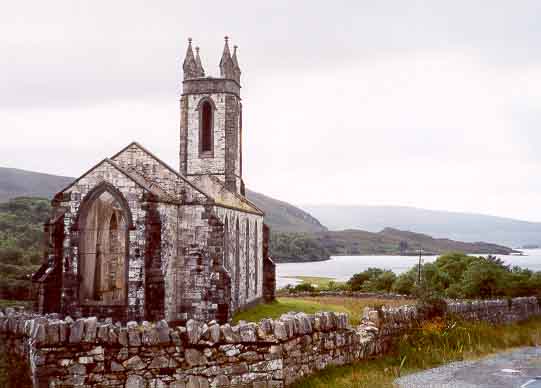
| Ruined church overlooking Dunlewy Lake |
At the end of the road at the entrance to the Poisoned Glen and just past Dunlewy village stand the mute ruins of a church. The walls of this haunting edifice are still complete. Indeed the white marble of which it was built was quarried just a few hundred yards away; the marble glows in the soft Irish light. Adding to the mystery, the adjacent graveyard contains a single gravestone. Unlike the Glen one can find few willing to offer explanations for the demise of this church. At one time it served as the local parish church and was thus part of the English establishment. Some may suggest that it was abandoned for the want of a congregation. Others will point to the new church built further down the valley after the old church became a ruin. Few will venture near the old church for it is said to be haunted. If it was burnt down in a fit of anger by a crazed survivor of the workhouse, many would know but none would tell. But it's mute and haunting testimony is inescapable.
Trailhead
Perhaps it is not surprising that these hosts of memories keep drawing me back to this enchanted place. In previous years I had splashed my way up into the Poisoned Glen, hiking to its glacier-sculpted head. In the year 2002, I returned, this time for a symbolic pilgrimage to the summit of Errigal. I drove through Falcarragh early one Sunday morning when not a soul was stirring and found the now-paved road that leads up to Dunlewy. Errigal loomed on the left and Dunlewy Lake slipped by on the right as I approached the Poisoned Glen. The road now continues to climb past Dunlewy (the village is down a narrow side road) and past the entrance to the Glen, headed for a saddle that lies to the south of Errigal. I stopped short of the saddle at a small trailhead parking area (55o1.50'N 8o5.39'W and elevation 735ft) on the left side of the road about 4mi from the N58/R251 intersection.
Hike
The route up the southeast ridge of Errigal is clearly evident from the trailhead (55o1.50'N 8o5.39'W and elevation 735ft) and begins with a hike up through the boggy heather on the left side of a small stream. The going here is very wet and mushy. After about half a mile, you veer left and follow braided trails through the heather heading for the obvious rocky trail on the slope ahead. Once there, you transition to a steep rocky trail that follows the southeast ridge of the mountain. Views open up of Croloughan Lake across the other side of the valley saddle and of the Poisoned Glen off to the south among the Derryveagh mountains. Beyond the Derryveagh range is Glenveagh National Park, previously the domain of the English landlord John Adair who, in 1861, evicted 244 tenants and cleared the land so as not to mar the views on his estate.
As you move onto the apex of the southeast ridge, the landscape to the east and north also comes into view with Altan Lake far below between Errigal and the summit of Aghla More (1916ft). Muckish Mountain (2197ft), the site of an annual barefoot pilgrimage on St. Patrick's Day, is a little further away beyond Aghla More. As you near the summit of Errigal, you surmount a shoulder where there is a large rock shelter and a cairn. From there it is a short way up a narrowing ridge to the 2466ft summit of Errigal at 55o2.00'N 8o6.67'W. In fact there are two sharp peaks on a narrow ridge 25yds apart, the trail between them being known as ``One Man's Path''. Provided you do not find yourself in the clouds (often the case), the panorama from the top is spectacular in all directions. Off to the north and northwest you will now see the Atlantic Coast and fabled Tory Island. It takes only about 1hr 15min to reach the summit of Errigal and less than 1hr to descend again.
If only it were that easy to right those centuries of wrong, or even to
put them behind us. Like that 1630ft hike to the top of Errigal, it
seems like a simple thing to do, to start afresh and build a vibrant
economic future. To any experienced hiker 1630ft
is almost trivial. And yet when I climbed Errigal a fierce cold wind
was howling out of the east. I was barely able to put one foot in front
of the other without losing my balance. And the rain hammered into my
clothes and face so fiercely, I could only with difficulty
look up to see where I was going. I asked myself why in the name
of God was I continuing in the face of this maelstrom. And yet when I came
to that summit ridge, the wind was miraculously gone and the beauty of the
world around me vindicated all my efforts. I could not
help wondering whether Hannah felt that way about her cottage. As she
said: ``Deed aye, it's the heart that matters''.
Last updated 9/1/00.
Christopher E. Brennen