ADVENTURES AROUND THE WORLD
© Christopher Earls Brennen
Hike A4. Mountain of the Devil
- Hiking time: 4 days or more
-
Estimated hiking distance: 24 miles using approach from east, 14 miles from west

- Elevation gain: 8200 feet using approach from east, 5700 feet from west
- Topo Map: ``Parque Nacional San Pedro Martir (San Pedro Martir National Park) including Picacho del Diablo'', map by Jerry Schad, published by Centra Publications. (See also trail maps in ``Camping and Climbing in Baja'' by John Robinson and ``The Baja Adventure Book'' by Walt Peterson.)
- Difficulties: Much rough bouldering and route finding, a little rope climbing
- Special equipment: 100ft of rope or webbing
Characteristics
The highest mountain in Baja California, Mexico, is a legendary peak known to the locals and all who attempt to scale her awesome walls as ``El Picacho del Diablo'' or ``The Mountain of the Devil''. While the official name according to the Mexican government is ``Cerro de la Encantada (The Mountain of the Enchanted)'' and the mountain was known to some for many years as ``La Providencia (The Providence)'' the name, El Picacho del Diablo, seems so appropriate to all who have walked in its shadow that it is doubtful that it will ever be known by any other name.
This magnificient mountain is a part and yet not a part of a massive block of granite that rises from the parched desert of Baja California about 100mi south of the US border and 30mi inland from the dusty village of San Felipe on the shores of the Sea of Cortez. The range itself is called the Sierra San Pedro Martir most of which consists of a wooded tableland between 8000ft and 9000 ft above sea level. On the west, the land rises to this elevation through a series of rolling benches mostly covered in scrub and mesquite bush. The eastern edge is much more dramatic with great yellow granite cliffs soaring into the sky. In terms of vegetation, the tableland on top is quite a contrast to the desert below. Lush meadows and stands of fir and cedar are interspersed with delicate aspen groves. Great heaps of boulders, granite knobs and ``chickenheads'' protrude in many places as if to remind the explorer of the essential ruggedness of the land. To protect this beautiful place, the Mexican government in 1947 established the first National Park in Baja, the ``Parque Nacional Sierra San Pedro Martir''. The only road into this park is a tortuous ribbon of gravel and rock that leaves the paved road, Highway 1, about 80mi south of Ensenada and climbs over the benches to the west of the tableland, eventually, 50mi later, arriving at the gate to the park. Along the way it passes two small villages, San Telmo and Sinaloa, and, higher up, the Meling Ranch.
The high points of the tableland are on the extreme eastern rim and the highest of these is the 9450ft peak known as Cerro Botella Azul or ``Blue Bottle'' though even this does not rise more than about 1000ft above the meadow. El Picacho del Diablo is part of a sharp ridge that protrudes to the east of the main massif. This ridge stretches east from Blue Bottle and then turns north, forming between it and the main block a dramatic chasm known as Canyon del Diablo. This canyon begins just below Blue Bottle, travels north about 15mi and then plunges eastward through a gap in the mountains to emerge in the desert and form a great dry lake, Laguna Diablo, that is part of the San Felipe desert.
In his book ``Camping and Climbing in Baja'' John Robinson describes El Picacho del Diablo as ``... truly one of the finest mountains in North America. Composed of huge slabs of fractured granite, precipitious, almost inaccessible, towering almost two miles into the clouds, the peak is a challenge to climb, a wonder to look at.'' It was first climbed by the legendary Californian explorer and map-maker, Donald McLain, who, after viewing the mountain during a surveying trip in 1905, returned in 1911 determined to conquer it. His account of the ascent from the west makes it sound deceptively easy. Others who followed found it much more difficult than at first appears. This is particularly the case when approaching from the tableland to the west, the route taken by most of the early explorers. Viewed from that vantage point it seems deceptively close. Some tried to traverse the ridge that extends from Blue Bottle to El Picacho only to encounter crevasses and knobs (``chicken heads'') requiring technical climbing gear and considerable time and effort. Others recognized the need to climb down from the tableland into Canyon del Diablo only to find it difficult to find a way up the mountain from below, in part because of the impossibility of seeing the peak until you are almost at the top and in part because of the existence of many blind canyons. After McLain's conquest, more than twenty years would pass before the second ascent by a group of six Sierra Club mountaineers in June of 1932. They set out from the tableland for what they thought would be a day hike along the ridge. Two days later they returned having reached the summit, but also having acquired a very healthy respect for the mountain. In the years that followed the mountain was climbed both from the east and from the west, but it was not until the fifties that Bud Bernhard discovered and described the one route up from Canyon del Diablo that requires no real technical climbing. This is known as Slot Wash and is the route that is described here.
These days successful ascents are made just about every year and many hundreds of climbers have experienced the majesty of El Picacho del Diablo. As with any challenging endeavour, there are also mishaps. In 1967 two Claremont College students, Eleanor Dart and Ogden Kellogg, were lost for almost a month before Bud Bernhard found Dart wandering in Canyon del Diablo. The two students were lucky to escape alive. That same year another climber was not so lucky. He had a heart attack and died while toiling up the precipitious Slot Wash. His friends buried him in a side canyon and continued on to the top to record the events in the summit register.
In this account we describe both the eastern and western approaches to the easiest ascent to the summit from Camp Noche in Canyon del Diablo. The time of year during which one could expect resonably comfortable weather conditions for the ascent of El Picacho del Diablo, is quite narrow. Much of the winter and spring are excluded because of snow on the summit. At the other extreme, the summer temperatures in the desert are in the 100 to 110 degree range. Thus the optimal time is the late fall when the desert temperature has fallen and before the snow arrives at the higher altitudes.
Trailhead
One of the best written guides to climbing El Picacho del Diablo is John Robinson's little book on ``Camping and Climbing in Baja''. In there, Robinson describes two basic routes for the ascent, namely an eastern and a western approach.
The eastern approach involves a rough four-wheel vehicle drive through the eastern desert to a trailhead near the mouth of Canyon del Diablo. A long hike up the canyon then allows access to a base camp, Camp Noche, near the head of the canyon. To access this trailhead drive over the US-Mexico border into Mexicali. Head for San Felipe and turn west onto Highway 3 after about 90mi. About 20mi from that intersection, you will come to a clearly marked signpost for a dirt road turning off the left side of the asphalt road toward ``Col de San Pedro Martir''. Four miles down that dirt road brings you to the edge of the large dry lake, Laguna Diablo. About 15mi long but only a couple of miles across, this dry lake has clearly been formed by the run-off from storms high in the Sierra San Pedro Martir. You transition onto the surface of the dry lake and head southwards following tracks down the middle of the dry lake. You need to find the dirt road that leads from the other side of the dry lake to the trailhead. It is identified by rough signs (some on old automobile tires) pointing toward ``Rancho Santa Clara''. These lead to a dirt road that you follow past a primitive ranch and corral where you should bear right behind the ranch and proceed about 5mi to a trailhead containing several old wooden shacks and various leftovers from previous hiking expeditions.
The western approach involves crossing the border at Tijuana and proceeding southward to Ensenada. From there you continue south on Highway 1 for 83mi through Santo Tomas and San Vicente to the point 10mi south of Colonet where you turn left off the asphalt highway onto the rough dirt road that leads, eventually, to Sierra San Pedro Martir National Park, some 60mi to the east and 8000ft higher. The road is slow and climbs quite steeply from bench to bench as it ascends the mountain range. You drive through the village of San Telmo, and, after 30mi, pass the Meling Ranch. This 10000 acre cattle ranch that was founded by the pioneering Meling family in the early 1900s, dominates the western foothills of the Sierra San Pedro Martir. For many years it has been a favorite, out-of-the-way resort for those who enjoy remote spots.
|
|---|
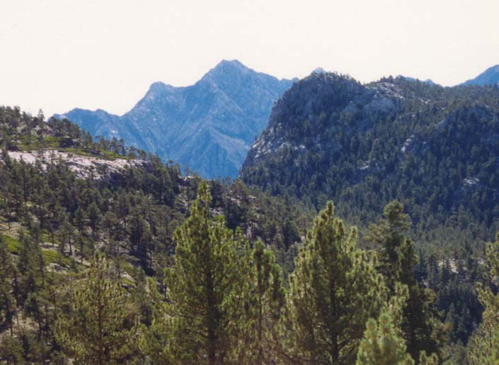
| El Picacho from the observatory |
After passing the Meling Ranch, the road again climbs steeply toward the tableland, and the flora begins to change from desert scrub to firs and aspens interspersed by meadows. You pass through the gates of the National Park and about 7mi beyond that emerge onto the tableland on a large meadow called Vallecitos that comprises the the heart of the Sierra San Pedro Martir National Park. Crossing the flat meadow, you can spot the Observatory on a ridge to the east. The road forks at the bottom of the climb up to the ridge. Later you will follow the right fork to the trailhead. But if you have time it is valuable and interesting to take the left fork and drive up to the Observatory. Near the top of the ridge the open road forks right to the observatory village, a group of cruciform Quonset-like huts set amongst the pines. However, you should walk up the left fork (closed to vehicles) to the observatories themselves. From that vantage point there are marvellous views of the desert to the east and of El Picacho itself in the distance (beyond a range of nearby peaks).
Returning to the task of finding the trailhead, you should drive down to Vallecitos meadow again and fork left at the road junction at the bottom of the ridge. The dirt road proceeds southeast and 2.25mi from the fork you will arrive at a large open space to the left of the dirt road where a number of large ducks indicate the start of the use-trail to El Picacho (30o59.93'N 115o27.07'W). If you are driving a four-wheel-drive vehicle and you feel more adventurous you can access another trailhead further along the road that deteriorates rapidly. This has the advantage of decreasing the length of the hike to the Canyon del Diablo overlook but I do not recommend this because that trail, though ducked, is harder to follow. Thus I recommend parking at the first trailhead.
Hike from the Vallecitos trailhead
From the 8130ft trailhead (30o59.93'N 115o27.07'W), hike up the broad arroyo following the ducks and the dry stream bed. Proceed in a generally southeast direction and follow the arroyo all the way to the rim of Canyon del Diablo. There are, however, several false ducked trails. Moreover, the trail leaves the streambed and turns left at one point to bypass a brushy section but then returns to the same streambed. About 2mi from the start you will pass the prominent Scout Peak on your left and a mile later, in the shadow of the even more dominant 9450ft peak known as Cerro Botella Azul or Blue Bottle, you should arrive at Blue Bottle Saddle (30o58.39'N 115o23.75'W).
The view that unfolds at Blue Bottle Saddle is awesome. A ducked trail leads 1000ft up a steep slope to the summit of Blue Bottle if you have time and energy to spare. The bottom of Canyon del Diablo lies almost a mile below you and yet, rising again on the other side, is an immense buff-coloured wall that culminates in the twin peaks of the magnificent El Picacho del Diablo. It is quite overwhelming; on a cerebral and physical level it challenges you. I had great difficulty believing that it was possible for me to climb it.
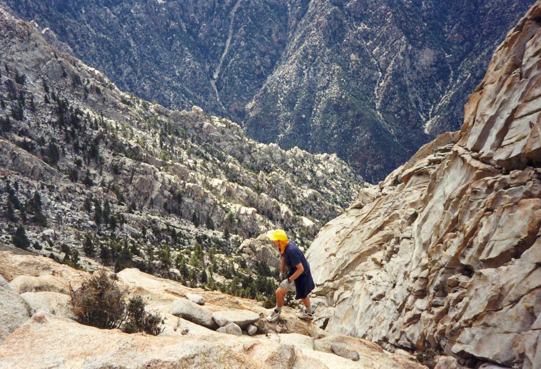
From the Blue Bottle Saddle, you must contour around the south wall of the Canyon del Diablo to your right before attempting to descend. The more direct route straight down is known as Gorin's Gully and contains several vertical sections requiring rappelling equipment. Such difficulties can be avoided by contouring far enough around to a large rubble strewn gully known as Blue Bottle Wash. Fortunately this route is well ducked and you should be able to find your way fairly readily to the wash and begin to descend. If in doubt continue to contour to the east. Then you follow the ducked trail as it descends Blue Bottle Wash. There are a few difficult places during the descent where large blocks of granite have created substantial obstacles and each of these require some route finding and some climbing. But, for the most part, the descent is just long and hard on the legs as you step from boulder to boulder.
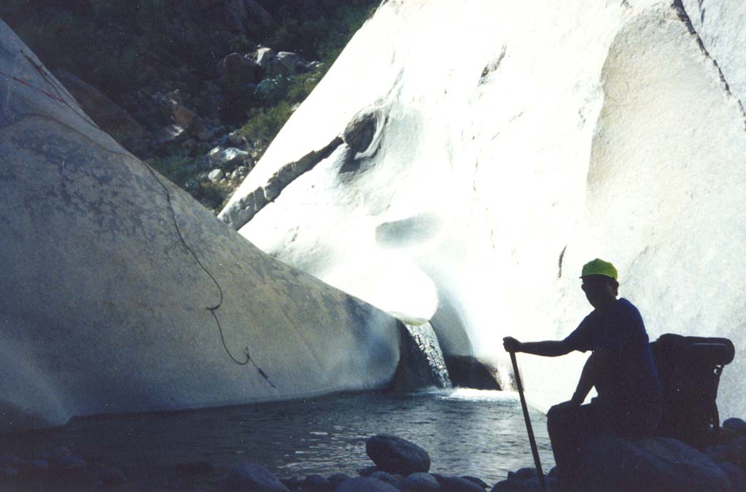
Near the bottom it is a relief to come upon a small but sparkling waterfall tumbling out of a side canyon to form a clear and inviting pool. It is a good place to refill your water bottles. Downstream there are several sections of thick brush to push through. If you are nearing nightfall, there are a number of places to camp but, if there is time, it is wise to press on get to Camp Noche. Proceeding down Canyon del Diablo, there are several reference points. Several hundred yards north of the pool, you should encounter a clearing surrounded by thin logs on a bench to the west of the stream. This small site is Camp Cedaroak at an elevation of 6600ft. Camp Noche (30o59.28'N 115o23.71'W and an elevation of 6300ft) is a larger site about a half mile further downstream on a bench to the east of the stream. An enticing swimming hole nearby will help confirm your destination.
Hike from the Canyon del Diablo trailhead
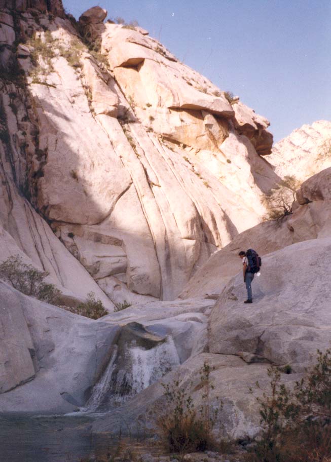
From the trailhead (elevation 2000ft), proceed due north parallel to the mountains. Crossing the dry gully, follow one of the many rough trails through a beautiful natural cactus garden on a gentle sandy downslope. After about a mile there is a small ridge that you proceed over or around and you should encounter a trail on the far side of this ridge. Turn left onto this trail that soon joins the riverbed of the stream emerging from Canyon del Diablo. The stream is usually quite full, providing assurance of a reliable water supply. As you enter the canyon, it becomes clear that you are in for a scenic treat, for the stream has carved a magnificent gorge through these mountains, creating great granite cliffs and a canyon bottom with huge boulders and beautiful pools filled with crystal clear water. But you will also make slow progress because of the frequent need to climb around waterfalls or over giant boulders. Early on you are faced with a small 4ft waterfall that presents a special challenge. Because the pool below it is over 6ft deep and there are no foot or handholds either under the waterfall or on the smooth, vertical walls on either side, it would be extremely difficult to surmount this obstacle. Fortunately, someone has fixed a pin in the rock high on the left-hand wall and hung a steel rope from this pin. The strategy is to climb up the leftside using the steel cable and then use either the cable or your own rope attached to it to swing up and over the waterfall.
 | 
| |
|---|---|---|
| Entering Canyon del Diablo | 4ft Waterfall |
The next mile above the 4ft waterfall is slow going with much climbing and bouldering. There are many beautiful waterfalls and pools, as well as several marvellous camp sites. It is a good strategy to try and reach one of these sites for the first night after driving south from the border. At one point near the end of this rugged section you need to follow the ducked trail that climbs up the left slope through the rocks and then contours through the bushes to a point upstream of a particularly difficult section where the stream comes down through a narrow inner gorge.
Upstream of this obstacle, at an altitude of 2700ft, Canyon del Diablo turns south and the going becomes easier for the next five miles or so. Eventually, at 4100ft you arrive at a fork where you go left. As the canyon narrows here, the brush increases. A waterfall at an elevation of 4300ft can be climbed on the left and shortly beyond this you again go left at a second major fork. And yet again at an elevation of 4900ft, you branch left for the third time. About a mile beyond this you will pass Smatko Camp (elevation 5700ft) in an area on the leftside of the stream. Then, finally, at 30o59.28'N 115o23.71'W and an elevation of 6300ft you arrive at Camp Noche, a long broad clearing on a bench on the left side of the canyon. The distance from the trailhead is about 10mi.
Summit Ascent
The ascent begins by climbing the large, shallow gully immediately above Camp Noche, named Night Wash by a group from UCLA who descended this way after nightfall. It is a steep but easy climb up a rocky slope that eventually reaches a ducked saddle at about 7400ft. This saddle leads to the much larger gully known as Slot Wash. The reason for this sideways entrance into Slot Wash is that the latter is too steep to be climbed in its lower reaches. From the Night Wash Saddle you contour around and then drop into Slot Wash (30o59.32'N 115o22.93'W). Here the going becomes significantly harder because you have to surmount many large boulders and a few steep falls. About 7800ft you may encounter running water in the stream.
 | 
| |
|---|---|---|
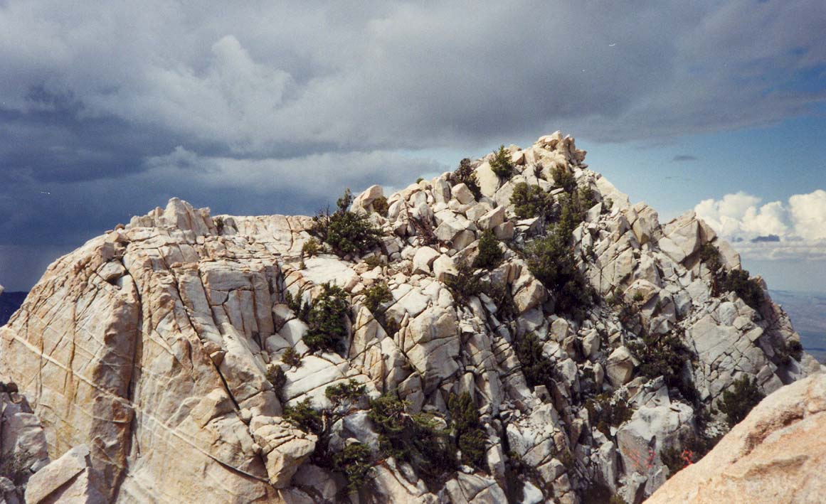
| Climbing toward the summit | The summit of El Picacho |
It is a tough climb, not so much because of the height but because the terrain is extremely rough. Moreover, while the route is well marked by ducks for some stretches, there are others in which ducks are few and far between. Worse still, there are ducked trails that go off in what are clearly wrong directions. Thus you must stop many times for navigational purposes. However, as you proceed up Slot Wash it is not difficult to identify the prominent rock mass that divides the Wash at an elevation of 8200ft. Here, you take the left branch though, almost immediately, you have to climb onto a shoulder on the left side of the canyon in order to circumvent several large waterfalls. Shortly thereafter you climb a rough dirt and rock slope to a point where a steep wash branches off to the north. Ducks lead in this direction into a wash at 30o59.48'N 115o22.70'W called ``Wall Street''. This leads directly up to the north summit of the mountain (30o59.30'N 115o22.51'W).
At this point, we should note that the summit of El Picacho del Diablo consists of a very steep and ragged ridge of granite. At the ends of this short ridge are the north and south summits measuring 10154ft and 10152ft respectively. It is a difficult, technical climb to get from one summit to the other, for there are several gaps and knobs that present substantial obstacles along the granite ridge.
As you reach the summit, a truly awe-inspiring vista explodes before your eyes and you feel as though you have been propelled into space. The drop on the far side, to the east, is several thousand feet straight down. The dry lake, Laguna Diablo, lies 10000ft below and you can even discern the various dirt roads leading to and from it. Beyond this lies the inland coast and the Sea of Cortez. And, turning around to look back in the direction from which you have come, you can make out the Pacific Coast through the desert haze. But time is short and you have to start to descend to have any hope of reaching camp before dark.
Return to Vallecitos trailhead
It is a long and tough climb up and out of the canyon back to Vallecitos Meadow. You must be careful not to leave Blue Bottle Wash too soon to begin contouring right toward the Blue Bottle Saddle. But mostly it is a hard slog punctuated by rest stops during which you can again admire the magnificient view behind you. Finally, you should reach the Blue Bottle Saddle (30o58.39'N 115o23.75'W) about lunchtime. Thus replenished, you begin the gentle descent through a shallow valley traveling northwest in the direction of Vallecitos meadow. The going is fairly easy, and as long as you head northwest, you will inevitably intersect the dirt road to the west. The trail is initially very well ducked and passes through some beautiful aspen groves. But then it seems to evaporate and you cross from one canyon to another on several occasions. With some luck you will encounter the ducked trail again in the flat, sandy-bottomed canyon that emerges onto the broad meadow where your vehicle was parked (30o59.93'N 115o27.07'W). It is a three mile drive north along the dirt road to the junction with the main dirt road to the Observatory.
Return to the Canyon del Diablo trailhead
It is a long and tiring hike back down Canyon del Diablo toward the desert trailhead. After the exhausting hiking of the previous day, it would be wise to try to camp near the point where the canyon turns east and to negotiate the hardest bouldering early the next morning.
Last updated 1/1/00.
Christopher E. Brennen