ADVENTURES AROUND THE WORLD
© Christopher Earls Brennen

Hike A1. Chipitin
- Hiking time: 5.5 hours
-
Estimated hiking distance: 2 miles

- Elevation gain: 1100 feet
- Topo Maps: Mexico 1:50,000 Topographical Maps, #G14C36 and C46, Allende and Rayones
- Difficulties: 7 rappels up to 150ft (one guided), much swimming
- Special equipment: Wetsuit, life jacket, helmet, harness, rappel device, extra carabiners and runners, two 160ft ropes, 30ft webbing
- Permit: None required
- ACA Rating: 4C III
Characteristics
In the Monterrey Peaks National Park, west and south of the city of Monterrey, Mexico, there are a number of spectacular canyoneering adventures. In this collection we feature three canyons in this National Park, namely Chipitin, Matacanes and El Laberinto, the first two of which are world class adventures.
These are rugged limestone mountains riven through with caves and with travertine encrusted canyons. Like limestone canyons elsewhere the blue-green water positively glows in the sun and the luxurious temperate foliage adds the final touch to a magnificently scenic canyon environment. Both Chipitin and Matacanes involve much swimming and a wetsuit is really essential equipment. Furthermore the local authorities require every canyoneer in these canyons to wear a PFD (personal flotation device or lifejacket) so don't set out without one.
Trailhead
Access to Chipitin follows most of the same arduous route as access to Matacanes and involves a long drive up a very rough, mountain dirt road that requires a high clearance, 4WD vehicle. The wisest choice would be to contract with one of the local guide services such as that Aventura (http://www.aventura.com.mx/) who are connected with the Hotel Hacienda Cola de Caballo, the best base for the three canyoneering adventures included here.
To get to Hotel Hacienda Cola de Caballo (25o22.14'N 100o9.61'W and elevation 2240ft) drive 36km south of Monterrey toward Cuidad Victoria on Mex.85 through the Villa de Santiago and turn off the highway at El Cercado where there is a signpost for Cola de Caballo. Turn right and drive 5.5km up NL20 to the hotel entrance on the right.
The starting and ending points for the Chipitin adventure are the tiny village of Potrero Redondo high up in the mountains. To reach Potrero Redondo from the Hotel Hacienda Cola de Caballo you continue up the asphalt road (Nuevo Leon 20 or NL20) for 5.5km to kilometer 11.5, the village of Puerto Genovevo (25o20.58'N 100o10.96'W and elevation 3710ft) where you turn sharp left onto a rough dirt road that is signposted to Las Adjuntas (10km) and Potrero Redondo (22km). This dirt road descends to a riverbed and follows this to the small village of Las Adjuntas (25o18.06'N 100o8.49'W and elevation 2420ft) at a major river junction. The adventure of Matacanes comes in from the right here and there is a rural food stand on the right just before the road crosses the river.
The road crosses the river and climbs steeply up the opposite slope. It also gets rougher as it climbs out of Las Adjuntas and then contours around the mountain finally reaching the village of Potrero Redondo at 25o15.89'N 100o9.72'W and an elevation of 4430ft about 12km from Las Adjuntas. During the last few kilometers look for the spectacular waterfall of Chipitin below you on the left. This is the waterfall of the last rappel in this adventure.
It will take over 2hrs to drive from the hotel to Potrero Redondo. When you arrive in the village, proceed on for about 50yds through the rural village and down the hill where you should see the signpost to the trail for Chipitin, signed the Cascades of Potrero Redondo or the Chipitin Cascades. Park in the flat area a little beyond the sign. If you have not employed a guide service then you might consider engaging a villager to look after your vehicle and another to guide you down to the watercourse at the start of this adventure (but not to the falls themselves which would be the end rather than the start of this hike.)
Hike
The trail to the Cascades of Potrero Redondo goes to the left between two of the village farms near the bottom of the hill. About 50yds down the trail you come to the top of a gully where the main trail goes along the left side of the gully and passes a sign for the cascades of Chipitin. Do not take that trail. Instead follow the use-trail along the right side of the gully and work your way down a steep wooded slope veering right if you are uncertain. Soon you will emerge onto a dirt road that you follow down to where it crosses the stream. This is the watercourse for the upcoming hike through Chipitin. You should reach the stream about 30min after starting out. If you have not already done so you should don your wetsuit, harness, PFD and helmet here.
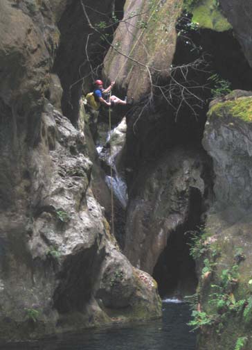
|
|---|
| Chipitin fifth rappel (Photo by Randi Poer) |
The swimming starts immediately in a beautiful travertine streambed with blue-green pools, overhanging foliage and some small jumps. Very quickly you come to the first rappel, a 30ft rappel from an anchor in the right wall down into a swimming pool. Swim a short way and then climb up the steep rock on the right to a shoulder where the hole-in-the-rock anchor for the second rappel is located. This second drop is an 80ft sloping rappel into a deep sunken pool. There are two options here. You can either rappel right down into the pool and then climb about 10ft to get out. Or you can veer to the canyon left as you descend and alight on the rock ledge before the pool. This second drop is immediately followed by a 100ft rappel from a hole-in-the-rock anchor on the left side down into an open area that once contained a large, deep pool but is now dry. You should reach this point about 1hr 45mins after leaving Potrero Redondo.
It is just a 50yds hike to the next rappel from a hole-in-the-rock anchor on the right side. A 150ft sloping descent deposits you into a deep pool with a swimming disconnect; it is a short swim to shore. About 100yds further down canyon a large tributary with flowing water (it may be the main watercourse) enters from the right. Here you must rappel down into the narrow slot through which this tributary runs. It is a 100ft rappel from a tree anchor into a narrow, wet slot with overhang and a swimming disconnect. Swim about 20yds to a gravel beach in this vertical-walled canyon.
At this beach you are greeted by a spectacular view. Just a short distance ahead the canyon proceeds through a narrow slot onto a flat platform at the top of a huge open vista. Between you and the platform is a deep swimming pool, and leading down to the pool is a most unusual feature involving a drop of about 20ft. This feature consists of a large rock mass with vertical slots at both sides seperating the mass from the vertical canyon walls. The mass slopes down to the pool and in the middle of this slope is a groove, a remarkable natural water slide. Slide down and swim to the platform.
The view from the platform is awesome. In the distance you look out at a wide rugged valley. Immediately in front of you is a huge 280ft vertical drop into a large blue-green pool. It is enough to make anyone's pulse quicken. Descending this monster takes thought and planning. There are several bolt anchors on a ledge off on the right wall and a guide line leading to those anchors. If you have a 300ft rope you could rappel from those anchors straight down through the waterfall to the pool at the bottom. Otherwise you need to carefully plan a two stage descent. The first stage is a 130ft rappel down to a steep ledge on the right where there is a solid tree anchor for the second stage. This first stage is tricky because of the offset. The first descender needs to rappel down to the sloping shelf staying as far right as possible. Then he or she needs to make their way across to the big tree at the edge of the second drop. The rest of the party could descend the same way. Alternatively, as the guides usually do, you could set up a guided rappel for the rest of the party using a rope around the second anchor at the top and the afore-mentioned tree. Once this first stage is accomplished the second rappel is a straightforward 140ft free-hanging descent into the pool with a swimming disconnect. The swim across to the gravel beach on the left side of the canyon is the last descending move of Chipitin. You should reach the beach at about 25o16.47'N 100o8.35'W about 4.5hrs after leaving Potrero Redondo.
Before you leave this beautiful place you will undoubtedly spend many minutes looking up at this spectacular waterfall and the wonderful rock formations all around. High up the huge travertine formations create an enormous cavern behind the falling water and allow you to view these falls from almost any angle.
Inevitably you resign yourself to the hike out with some regret. The good trail back up to Potrero Redondo begins between two of the large boulders at the back of the gravel beach. It first contours downstream before beginning many switchbacks during the climb out of the canyon. You finally return to the village at the same trailhead where you started. The hike out takes about 1hr for a total hike duration of about 5.5hr.
Last updated 5/16/05.
Christopher E. Brennen