ADVENTURE HIKES AND CANYONEERING
IN THE SOUTHWEST
© Christopher Earls Brennen

|
|---|

|
Hike G1. Willow Creek, Death Valley
- Hiking time: 6.5 hours
- Estimated hiking distance: 4.4 miles
- Elevation gain: None
- Topo Maps: Gold Valley
- Difficulties: About ten rappels, one about 170ft, considerable downclimbing
- Special equipment: Two 200ft ropes, 200ft retrieval line, 40ft webbing, a few rappel rings, rappelling equipment, helmets and leather gloves
-
ACA Rating: 3A III

Characteristics
Death Valley National Park contains some of the most rugged and fantastic landscape in the world and this makes for some marvellous adventures and canyoneering experiences. Though the heat in the summer is intolerable, the Park has the advantage that the mild winter weather allows outdoor activity when much of the rest of the southwest is too cold and wintery. While it does occasionally rain in the valleys and snow often covers the high peaks in the winter, at lower elevations the temperatures are perfect for exploring the many narrow, multicolored canyons that line both sides of the flat valley bottom. This collection of adventures contains several in Death Valley National Park. Though the hike to the summit of Telescope Peak is a summer outing, the other, canyoneering adventures included in this collection are best suited for the late fall, winter and early spring. If you plan to do much hiking in the Park, I strongly recommend you buy Michel Digonnet's excellent book "Hiking Death Valley".
One of the most challenging adventure hikes in Death Valley is a descent of Willow Creek. Though the very long car shuttle is a disadvantage, Willow Creek is one of the few bolted canyons in Death Valley. This speeds progress but removes some of the adventure. The upper section is a relative easy off-trail hike past a series of springs that each nurture a small oasis of willows, cane and tamarisk. Here is one of the refuges of bighorn sheep in the Park and evidence of their presence is ubiquitous. The second section is a dramatic and convoluted gorge with at least ten spectacular rappels usually with running water, a most uncommon feature in Death Valley. The last couple of miles are an easy walk out of the canyon and across a huge alluvial fan.
Trailhead
The Willow Creek descent requires a very long and rough car shuttle. First you must deposit a return vehicle on Highway 178 close to the canyon mouth. The location is a short spur dirt road leading to a parking area (36o3.96'N 116o44.69'W). The spur road leaves the east side of Highway 178 just north of Mormon Point, 14.3mi south of Badwater or 14.8mi north of the junction with the Harry Wade Road. It is probably best to deposit the return vehicle there the evening before your hike and then drive part of the way toward the trailhead. To get to the trailhead drive south on Highway 178 for 32mi to the turnoff left onto the dirt road signposted Furnace Creek Wash and labelled Greenwater Valley Road on many maps. Note that the southern turn-off onto Furnace Creek Wash is a surprisingly long way west of the northern turn-off, the one you want. Both have street signs. You may choose to camp at one of the many acceptable sites along Furnace Creek Wash though Park regulations demand that you camp at least two miles from the asphalt road. To continue to the Willow Creek trailhead, drive north on the good dirt surface of Furnace Creek Wash to a point 10.6mi from Highway 178 to find the left turn-off onto Gold Valley Road which is not signposted. This is a rough dirt road for which a high clearance, 4WD vehicle is probably essential.
It is 12.5mi along the Gold Valley Road to where the road ends at the Willow Springs trailhead. The road rises slowly to a 4460ft summit about 7.5mi from the Furnace Creek Wash Road and then descends gently to the 2635ft trailhead. The roughest sections are just before and after this summit with the road elsewhere being in fairly good condition. Immediately before the summit there is a little spur road that goes right at the bottom of a dip; stay left here. Then, after the summit at 8.2mi and an elevation of 4240ft the road forks; take the right fork (really straight on). The left fork rejoins the main route at about 11.3mi and 3250ft. Over the last quarter mile, the road descends the Willow Creek wash and the valley begins to deepen. At 12.5mi, the trailhead (36o2.96'N 116o41.32'W) has a convenient turning loop.
It should take about 20min to drive from Highway 178 along the Furnace Creek Wash to Gold Valley Road and another 50min to reach the Willow Spring trailhead.
Hike
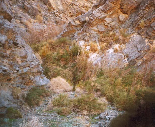
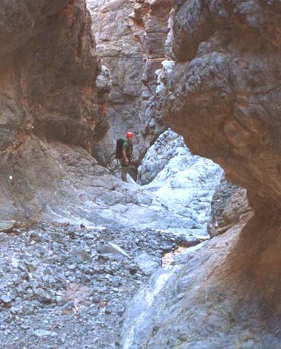
The trailhead (36o2.96'N 116o41.32'W and an elevation of 2635ft) is just upstream of the dense thicket of brush watered by Willow Spring itself. However, as with all the other brush thickets, the growth is confined to the canyon bottom and the surrounding slopes are almost devoid of vegetation. Therefore, as long as the canyon walls are not vertical the brush is easy to bypass on either side. In the case of Willow Spring the well-worn trail proceeds around the left side. The second, third (36o2.10'N 116o41.77'W) and fourth springs all follow within 20min and are bypassed on the right. At the fourth spring, 0.8mi from the trailhead, the canyon narrows and the trail proceeds over a high shoulder on the right. This is the start of the wet narrows. We note that in winter when you should be undertaking this hike, the stream flows almost all the way down this canyon before disappearing after the last waterfall; it does however disappear underground for several gravel-filled stretches within the canyon.
 | 
| |
|---|---|---|
| Spring in the upper canyon | Telescope Peak in the distance |
After the fourth spring shoulder you descend to the canyon bottom and follow the wet narrows for about 30min to two easy downclimbs of small waterfalls, 12ft and 14ft high. The canyon is deepening and the walls are closing in so bigger drops are inevitable and, about 65min and 0.8mi from the start at an elevation of 2000ft, you arrive at a sloping 35ftwaterfall (36o3.21'N 116o42.11'W). There is a high and lengthy route around this waterfall on the right side but it is readily rappelled from a tree anchor near the edge of the stream on a lower lip. About 10min later the canyon becomes so narrow it is almost a slot and, just after a tree-filled section, there is an awkward 13ft drop caused by a large chockstone. A belay-assisted downclimb or a short rappel is necessitated by the overhang. The canyon broadens again and there are several small and attractive cascades that are readily downclimbed as the canyon turns left and proceeds southwest. Here the stream disappears into the broad gravel-filled bottom.
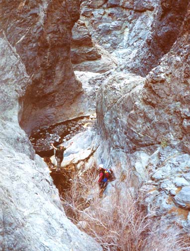
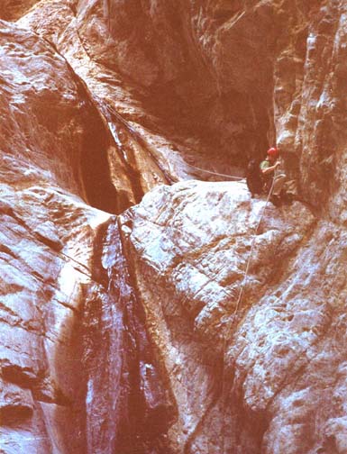
But this gentleness soon ends. At 1.6mi and 2hrs from the start at an elevation of 1510ft you come to the fifth spring, a small canyon-spanning thicket where the flowing stream reappears. This brush can be bypassed using the trail over a high shoulder on the left though it is almost as easy to push through the short stretch of brush. Immediately beyond this thicket is the entrance to the main Willow Creek Gorge (36o3.12'N 116o42.56'W). Here the canyon turns sharp right, narrows and drops dramatically. At the entrance there is a series of small drops in a very narrow chute and this is followed by a 25ft waterfall that is readily bypassed on the far right. This is immediately followed by a 70ft drop that is best rappeled over the shoulder on the left using the large tree in center of the canyon as anchor. This is followed by an easier stretch of narrow canyon with a number of challenging downclimbs all of which have excellent foot and handholds.
 | 
| |
|---|---|---|
| Entrance to Willow Creek Gorge | Second two-stage rappel |
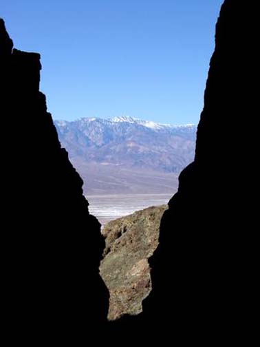
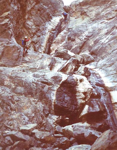
These lead to the top of the serious technical section, 3hrs and 1.7mi from the start at an elevation of 1360ft. From here there is a long series of substantial bolted rappel descents. The first drop-off is a two-stage 170ft rappel with a two-bolt anchor on the rock shelf on the right side. This can be done in a single rappel or in two rappels of 80ft and 90ft using the large shelf half-way down that has a piton anchor on the right side. The canyon is now continuously narrow with towering walls on both sides. Just a short distance downstream of the big double falls you come to the top of a very similar but smaller two stage drop (40ft and then 50ft for a 90ft total) with good double bolt anchors for both drops. Here there is a spectacular view down into Death Valley with Telescope Peak windowed in the distance. This is almost immediately followed by a 50ft rappel from a double bolt anchor in the left wall. This one has a hanging pool about half way down. Keep to the right to step over the pool. At the bottom you descend through the 1000ft contour.
 | 
| |
|---|---|---|
| Mark avoids a hanging pool | Narrows in the lower canyon |
Almost immediately (and about 4.5hrs from the start) you come to another 50ft rappel from a double bolt anchor in the left wall. This one also has a pool under an overhang about a third of the way down. It is a challenge to avoid this pool or a soaking in the falls that follow. This is followed shortly at an elevation of 820ft by a 45ft rappel down a narrow slot from a double bolt anchor on the left. It is hard to avoid the shallow pool at base of this descent. This is followed by a few hundred yards of gravel-bottomed canyon with vertical and sometimes overhanging walls (reminiscent in places of the Subway in Zion) before you arrive at the top of the last rappel, a broad 80ft drop from a double bolt anchor (36o3.20'N 116o43.16'W). The stream usually dissappears into the gravel at the bottom of this last waterfall. You should reach this point (590ft elevation) about 5.5hrs from the start having completed about 10 rappels and come about 2.2mi.
Beyond the last waterfall the going is easy. The canyon turns sharp left and you proceed through a vertical gate that gradually decreases in height. About 0.2mi later at an elevation of about 490ft the canyon rather suddenly broadens and the wide gravel wash makes for easy walking. From here it is about 2mi to the return vehicle. As the canyon continues to widen Highway 178 will come into view in the distance. Veer left as you exit the canyon and begin to descend the broad alluvial fan that Willow Creek has laid down. Soon you will be heading almost southwest and the parking area with the return vehicle should come into sight. You should reach this end point (36o3.96'N 116o44.69'W and elevation -220ft) about 6.5hrs after the morning start having covered 4.4mi.
Note that although the descent can be completed quite readily in the span
of winter daylight, the vehicle recovery will probably not be completed during
daylight hours. The drive back along Highway 178 to Furnace Creek Wash
Road and then along the Gold Valley road back to the trailhead will
take about 1hr 45min. Then you still have to drive back out from
the trailhead.
Last updated 17/01/04.
Christopher E. Brennen