ADVENTURE HIKES AND CANYONEERING
IN THE SOUTHWEST
© Christopher Earls Brennen

|
|---|

|
Hike F2. Wheeler Peak
- Hiking time: 5.5 hours
- Estimated hiking distance: 8.6 miles
- Elevation gain: 3000 feet
- Topo Map: Hiking Map and Guide, Great Basin N.P.
- Difficulties: Perhaps the crossing of a snow field
- Special equipment: Crampons and ice axe if snow field crossing needed
-
ACA Rating: 1A III

Characteristics
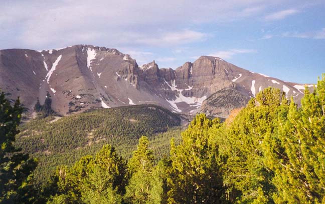
In a lonely corner of the Nevada/Utah desert, more than a hundred miles from a town of any size, there is a rarely visited national treasure called the Great Basin National Park. And dominating this Park, soaring into the desert sky is a 13000ft mountain called Wheeler Peak. It is a beautiful place, a diamond in the desert and a marvellous summit adventure hike. For the night before the hike, there are a number of very nice campgrounds with sites among pinyon-juniper woodland, scattered aspen groves and beside a bubbling stream. I recommend rising early and allowing time to enjoy the spectacular Wheeler Peak Scenic Drive as you drive up through the park toward the trailhead, passing through several vegetation zones, from the pinyon-juniper woodland to a zone of mountain mahogany and manzanita to denser forests of Engelmann spruce and Douglas fir. The road ends in the shadow of the snow-scattered Wheeler Peak and the rugged crags around it. It is wild and beautiful mountain scenery, a marvellous surprise for the desert traveller. And, if you are lucky like me, you may even glimpse the fabulous flight of a golden eagle as it rises majestically above the forest in the light morning mist.
Trailhead
The Wheeler Peak Scenic Drive in the Great Basin National Park ends in a parking area next to the Wheeler Peak campground. However, the trailhead (39o1.04'N 114o18.20'W and elevation 10161ft) for this hike is a turnout at the side of the road about 0.7mi before you reach this terminus. There is ample trailhead parking at the turnout on the west side of the road and the peak trail is well indicated.
Hike
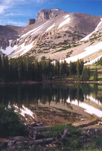
The initial section of the trail is almost level as it contours through the Engelmann spruce forest toward Stella Lake. About 1mi from the start you emerge onto a very pretty meadow and come to a trail junction at 39o0.47'N 114o19.06'W. The trail to the summit switchbacks round to the right but, before starting in that direction, walk straight ahead about 100yds to the north shore of Stella Lake (39o0.36'N 114o19.12'W and elevation 10380ft). This jewel of crystal clear water surrounded by pine forest reflects the backdrop of Wheeler Peak looming high above its southern shore.
 | 
| |
|---|---|---|
| Wheeler Peak from Peak Road | Wheeler Peak from Stella Lake |
Returning to the trail junction, you follow the switchback that climbs toward the ridge off to the west. The trail is still easy here with a gentle gradient all the way up through light forest and open meadows to a saddle in the ridge at 39o0.32'N 114o19.38'W and an elevation of 11000ft. This elevation coincides with the treeline and here a number of ancient bristlecone pines dot the rock-strewn landscape. Beyond the saddle, the increasingly rough and faint trail switchbacks up the broad treeless apex of the ridge to the south of the saddle. Soon only low alpine plants remain and, about 12000ft, the rocky ridge levels out for about 0.4mi before you arrive at the bottom of a steep talus slope. A rough use-trail winds through, around and over the boulders as you begin the climb up the last 1000ft to the summit. For most of this climb you stay on the apex of the ridge with steep drops not far away on both sides. To the right there unfolds an increasingly panoramic view of the valley far below to the west. To the left are the spectacular cliffs on the north side of Wheeler Peak. If you peer over that side you will see several small glaciers in the hollows far below, the largest being known as Wheeler Glacier. And back behind you are the lovely lakes, Stella and Teresa. After a breathless climb up this steep rock field, you approach the summit ridge. Almost at the top, there is, even in high summer, a fairly large snow field that you may be able to bypass on either the left or right. I went to the left and, beyond the snow field, a brief climb took me to the summit ridge.
Spectacular all around views welcome you to the 13063ft summit (38o59.15'N 114o18.85'W) after a 4.3mi or 3hrs 15min hike from the trailhead. The summit itself is composed of great slabs of quartzite formed when some ancient sandstone deposit was heated, compressed and metamorphosed. The scenery is particularly magnificient at the far, eastern end of the summit ridge where the cliffs fall off all around and Jeff Davis Peak (12771ft) rises vertically on the other side of an enormous amphitheater or cirque. At the bottom of that awesome bowl, you look down on the ice and snow of the Wheeler Glacier. Turning around the view to the south is dominated by a much larger but gentler amphitheater framed in the distance by the 12298ft Baker Peak. Together these summits are part of the north-south running Snake Range whose boundary is the broad Spring Valley far below to the west.
The return hike to the trailhead
(39o1.04'N 114o18.20'W)
takes about 2hrs 15min. In summary,
a great, and moderately easy, adventure hike.
Last updated 9/9/99.
Christopher E. Brennen