ADVENTURE HIKES AND CANYONEERING
IN THE SOUTHWEST
© Christopher Earls Brennen

|
|---|

|
Hike E4. Water Canyon
- Hiking time: 6 hours
- Estimated hiking distance: 3.3 miles
- Elevation gain: 1260 feet
- USGS Topo Map: Hildale (UT,AZ)
- Difficulties: 9 rappels up to 170ft, some swimming
- Special equipment: Two 200ft ropes, harnesses, helmets and rappeling gear, 50ft webbing, several rappel rings, dry bags (wetsuit on colder days)
- Permit: None needed.
-
ACA Rating: 3B III

Characteristics
Water Canyon is a great little technical canyon just outside of Hildale, Utah and a short way south of Zion National Park. It involves a hike up the trail in the canyon to the mesa rim with some spectacular views of the sculpted sandstone and slickrock topography. The subsequent descent involves nine rappels including two of just under 170ft. Not only is it a beautiful canyon but the descent has a little bit of everything, big drops, narrow slots, swimming pools, and an interesting pothole. Unless the weather is hot a partial (or even full) wetsuit is advisable for the swims.
All of the rappels have existing anchors, either bolts or webbing wraps. Note that the canyon requires no permit and that it is often used for commercially-guided trips that are not permitted, for example, in Zion National Park. Visitors to Zion might want to keep this canyon in mind if they have difficulty getting a permit for a canyon within the Park.
Trailhead
The town of Hildale in southwestern Utah is on Highway 59 (Arizona Highway 389) just north of the Utah/Arizona state line. In Hildale turn northeast at the Bank of Ephraim onto Utah Avenue and proceed east for about 1.8m to a stop sign. Proceed straight on. The road soon turns north. At 2.8mi from the highway there are two dirt roads that take off on the right. The second of these dirt roads is Water Canyon Road; proceed up this road but note that it could pose a problem in the event of rain. About 3.5mi from the highway the road forks with a branch turning right to Short Creek. Continue straight on (left) and stay on the main road until you reach a parking area just beyond a small reservoir. This is the Water Canyon trailhead at 37o2.27'N 112o57.29'W and an elevation of 5200ft.
Hike
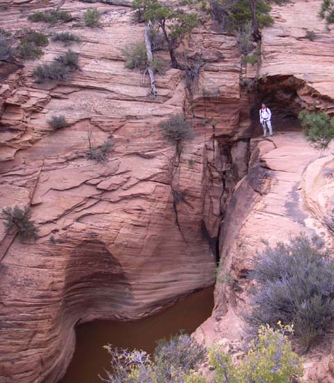
From the parking area at 37o2.27'N 112o57.29'W and an elevation of 5200ft the well-trodden trail proceeds north through the brush on the left side of the canyon. As you begin to climb into Water Canyon you may be able to see the Water Canyon Arch high up on the left. The trail gradually ascends the brush covered slopes on the canyon left until the walls steepen and narrow and you contour into the Water Canyon Narrows where the watercourse has a subway-like feature. You should reach the canyon bottom here at an elevation of 5610ft about 45min from the start.
|
|---|
| First drop in Water Canyon (Photo by Ira Lewis) |
Ascend a few feet in the narrows before switchbacking to the left and climbing back up the side of the canyon. Here you are bypassing the long, 170ft last rappel. The trail soon contours back into the canyon bottom at the top of this last rappel. Then you follow the trail upstream alongside the streamcourse for about 100yds to where the trail again switchbacks up the left wall, leaving the canyon bottom for the last time. It is now a matter of following the steep trail as it continues to climb toward the mesa rim high on your left. As you climb the magnificent slickrock sculptures of Water Canyon are increasingly revealed and you may catch a glimpse of the bighorn sheep that live in this vertical playground.
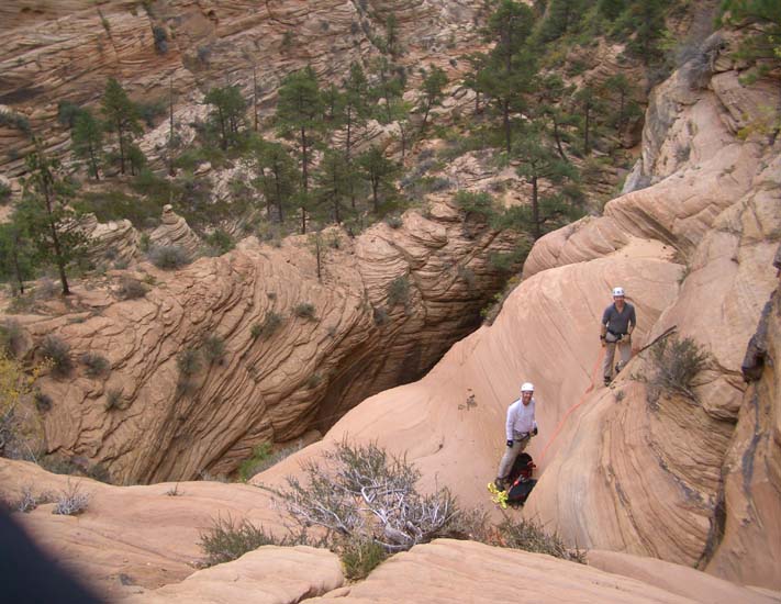
You should reach the mesa rim at 6400ft just about 2hrs after starting out. Though the trail becomes a little faint at the very top, veer a little right and you will easily recognize Top Rock, the distinctive waypoint that marks the high-point of this hike at 37o3.13'N 112o57.90'W. After a brief pause to admire the marvellous views from the mesa rim, you begin the easy descent back down into upper Water Canyon which has curved around to the north of you. The descent begins by following a worn path northwest down through some trees to a shallow gully which you can descend all the way to the streamcourse. You should veer left during the gully descent if you find your way blocked by a steep cliff. You should reach the bottom (elevation 6300ft) about 2hrs 15min from the start. Here you encounter a series of sculpted pools in the slickrock bottom. You should put on your rappelling gear here for the first rappel is just a few yards downstream.
The first drop is only about 20ft and can be rappelled from a tree on the left though it is also readily bypassed further to the left. This is immediately followed by the second rappel, a 60ft drop using a tree on the right as the anchor. There is a little shelf at bottom that with a little on-rope pendulum at the bottom will allow you to avoid the pool. At the bottom the streamcourse turns sharply right and enters a slot with two pools and two short drops. This section can be rappelled using the bolt in left wall. Alternatively you may choose to avoid the water by climbing the shoulder on the left before the slot and bypassing this short section by proceeding along the ridge and descending into the end of the slot using an easy sloping ledge.
 | 
| |
|---|---|---|
| At the top of upper 160ft drop in Water Canyon | Narrows in Water Canyon (Photo by Ira Lewis) |
At this point 3hrs from the start at an elevation of 6150ft you arrive at a point where the streamcourse proceeds over a large slickrock drop-off to your left. The first stage in the descent is a short 30ft rappel down to a broad ledge using a bolt in the right wall. Halfway down this short rappel there is a remarkably deep but small pothole in the streambed. This is easily bypassed but worth pausing to examine and perhaps explore. Below it on the broad ledge you will find a two-bolt anchor for the 160ft rappel down to the bottom of the drop-off. Care needs to be taken here to avoid rope hang-up in the deep rope grooves cut into the lip of this rappel. The last descender needs to make sure that the rappel rope and the pull line lie down into different grooves and that the pull line groove will allow the knot to slide through or over fairly easily. The pool at the bottom is about waist-deep.
After this drop-off there is a nice section of extreme narrows where you may need to squeeze through sideways. Then the streamcourse opens up and you arrive at the top of a large swimming pool. This can be avoided by rapping off a tree to the left and then bypassing the pool using the ridge on canyon left. Alternatively it can be tackled directly by first climbing down into a streamcourse slot immediately above the pool and then rappelling down the rest of the slot for about 20ft using a webbing anchor around logs. This ends in a swimming disconnect. The swimming pool is immediately followed by a 15ft dry rappel from a low tree in the right center. From the bottom of this you then descend slickrock to a ledge on the canyon right above a 100ft drop-off on your left. The anchor is a tree on the ledge ahead and a little above the low point and this sets up a 100ft dry rappel down into a sandy slot. This leads to an attractive sandy corridor that slots up and leads to an awkward obstacle where there are two choices.
At the end of the sandy slot, the streamcourse turns sharp right and drops into a series of potholes, one with a deep pool that can be grimy. This series can be descended to a place where there is a longer drop (and a bolt anchor on the right wall to continue the descent). However, many may choose the alternate dry route which is to climb up onto the ridge to the right at the top of the potholes and then descend the other side of the ridge to a large tree that overlooks the longer drop. A sling around the tree allows an 80ft rappel down past the bolt anchor at the end of the potholes. There is also a larger pool at the bottom of the 80ft rappel that can be avoided using a small ledge to traverse to canyon left and then step back onto a large boulder.
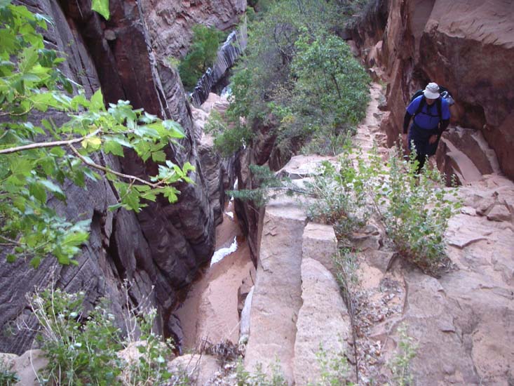
At this point (elevation 5860ft) you should be about 4.5hrs from the morning start. From the bottom of the 80ft rappel, climb over the boulders on the canyon right to a ledge that avoids a narrow wet slot. Then a little further on climb up on the left to avoid another wet slot and rappel down about 60ft from a tree anchor to a sandy area on the canyon left. You will now join the trail that you used to ascend this section and it is only a few yards downcanyon to the top of the last rappel. This uses two bolts in the left wall of the streamcourse slot (visible from the trail) to descend 170ft down to a swimming disconnect. Then you swim down the slot to rejoin the trail.
It only remains to exit the subway-like section and to follow the trail
down the canyon to the parking area
(37o2.27'N 112o57.29'W and an elevation of
5200ft). The hike should take about 6hrs during which you will
cover about 3.3mi.
Last updated 10/10/07.
Christopher E. Brennen