ADVENTURE HIKES AND CANYONEERING
IN THE SOUTHWEST
© Christopher Earls Brennen

|
|---|

|
Hike K16. Vivian Creek
- Hiking time: 4.2 hours
- Estimated hiking distance: 1.8 miles
- Elevation gain: 1000 feet
- USGS Topo Map: Forest Falls
- Difficulties: Four large, wet cascades measuring 160ft, 90ft, 70ft and 120ft.
- Special equipment: Rappeling gear, harnesses, 60m rope, 60m recovery cord or second rope, five rappel rings, 50ft webbing, drybags.
-
ACA Rating: 3B II

Characteristics
Some of the most accessible and spectacular adventure hikes in the San Bernadino Mountains can be found on the steep sides of Mill Creek near Forest Falls in southern California. These are beautiful wooded slopes of pine and cedar with lovely crystal streams and panoramic views. The Vivian Creek Trail switchbacks up the steep northern wall of Mill Creek Canyon. It is one of the most popular hiking trails in the San Bernadino mountains and leads eventually to the summit of Mount San Gorgonio. In this adventure you use this trail to climb 1000ft up to a place where you can easily access Vivian Creek itself. From there you follow the creek back down to Mill Creek wash. This descent involves negotiating four large and beautiful cascades using four or five exciting rappels. The water is cold and the flow may be excessive except during the summer. But on a warm summer day this is a glorious canyoneering adventure.
Trailhead
From Interstate 10 just east of San Bernadino take the Orange Street or Route 38 offramp. At Orange Street, turn under the freeway and drive north on Route 38. After a few blocks Route 38 turns right. You drive east through Mentone and then wind your way up past the Mill Creek Ranger Station and into the valley of Mill Creek. The spur road to Forest Falls continues up Mill Creek Canyon at a place where Route 38 makes a sweeping left turn. Drive up through Forest Falls to the end of the road where there is trailhead parking for the Vivian Creek Trail. Park here at 34o4.91'N 116o53.47'W and an elevation of 6090ft.
Hike
From the parking area (elevation 6090ft) at 34o4.91'N 116o53.47'W hike east along the well-marked Vivian Creek Trail following the south bank of Mill Creek. After about 0.5mi the trail crosses the Mill Creek Wash; cross the wash and follow the trail as it switchbacks up the north wall of Mill Creek Canyon. The climb is steep and unrelenting but eventually begins to ease as you pass the sign entering the San Gorgonio Wilderness Area at 34o5.03'N 116o53.05'W and an elevation of 7090ft. Just a few minutes later the trail approaches the east bank of Vivian Creek and you have reached the drop-in point just a little over 1hr and 1.24mi from the start.
 | 
| |
|---|---|---|
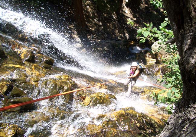
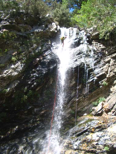
| Descending the first falls | The fourth falls |
This is a beautiful little stream in the woods with sparkling waterfalls and banks strewn with pine cones. Turning downstream, follow a use trail on the left bank and very soon you come to the lip of the first awesome drop in Vivian Creek Canyon. It is a little difficult to see the extent of the drop because the lip is set back from the main falls by a small preliminary waterfall and hanging pool but the total drop is about 140ft. There are three ways to descend all of which use as anchor a webbing wrap around the large pine tree in the middle at the top: (1) The easiest, right-side route is to descend about 12ft into the hanging pool and then climb up the obvious shoulder on the right side of the lower lip; go behind the big tree at the top of the shoulder and continue your rappel down about 40ft to two large trees with a safe platform between them. Then rig a second anchor around one of these trees and continue your descent down the right side of the waterfall for 100ft to the first big ledge at the bottom. (2) A more demanding but more spectacular route is down the left side of the falls. From the hanging pool continue the first rappel over to the left to a substantial tree just a few feet below the lower lip. From a small ledge below this tree, rig a webbing anchor on the tree and rappel down about 120ft on the left side of the waterfall. Note that the small ledge at the intermediate station can probably only hold three people (at most). (3) It is also possible to descend down the middle of the falls on a single rappel using a 160ft rope and a recovery cord of the same length. This is more feasible in late summer when the flow is reduced. You should reach the bottom of the first falls (elevation 6860ft) about 2hr 15min after the morning start.
Downstream of the first falls there are a number of small downclimbs and one more substantial drop that is easily circumvented by contouring over to the left and descending a lateral gully. Then, at 6760ft and about 2hr 40min from the start, you will arrive at the top of the second big falls, a 90ft cascade that is best descended using a webbing wrap around a big tree on the right side of the lip. This takes you down the right side of the cascade to a small, tree-lined platform. The third falls (elevation 6620ft) follow almost immediately; you should cross the stream to a large tree in the shade at the top of the left side of these third falls. It is difficult to discern this drop through the foliage at the top. A webbing wrap around the tree anchors the 70ft drop over some slippery boulders. You should reach the bottom of these falls about 3hr 15min after the morning start.
The fourth and last falls are just a short distance downstream at an elevation of 6530ft; these are a lovely vertical cascade of 100ft. The anchor is a stout tree just to the right of the lip. The descent is wet and has a section of free rappel. You can avoid the worst of the stream by rappeling down on the right of the falls.
From the bottom of these last falls it is an easy scramble down to the end
of Vivian Creek where it emerges into Mill Creek at
34o4.94'N 116o53.30'W and
an elevation of 6210ft. Crossing the Mill Creek wash it is less
than 100yds down to the trailhead where you left your vehicle at
34o4.91'N 116o53.47'W and
an elevation of 6090ft. It should take about 4hrs 15min to
complete this hike of 1.8mi.
Last updated 8/12/06.
Christopher E. Brennen