ADVENTURE HIKES AND CANYONEERING
IN THE SOUTHWEST
© Christopher Earls Brennen

|
|---|

|
Hike G12. Telescope Peak
- Hiking time: 7 hours
- Estimated hiking distance: 14 miles
- Elevation gain: 2916 feet
- USGS Topo Map: Telescope Peak
- Difficulties: None in summer, steep snow slopes in winter
- Special equipment: Crampons and ice-axes when snow-covered
-
ACA Rating: 1A III

Characteristics
Though included in this collection of adventure hikes, this ascent of the 11049ft Telescope Peak that towers over the west side of Death Valley, is a straightforward hike along a well-worn trail for the period, June through October. However, it becomes a significantly more challenging adventure when the mountain is covered in snow as is normally the case from November through April. Then, crampons and ice-axes and experience with snow climbing are required. Even quite late into May or June, the snow covering the steep slope immediately below the summit ridge can be quite a challenge.
The rewards for this effort are spectacular views of both the highest and lowest points in the contiguous United States, and the marvellous wildernesses surrounding them. The lowest point, Badwater (elevation -280ft) lies 20mi off to the east in the depths of Death Valley. Surrounded by salt flats and forbidding deserts it is, in the summer, one of the more frightening places on the face of the earth, with temperatures somtimes above 130 degrees Fahrenheit. The highest point, Mount Whitney, 70mi to the west is 14494ft above sea level, a magnificient, brutal incision in the sky, surrounded by some of the most beautiful mountain scenery in the world.
Logistically, the best way to tackle Telescope Peak is as a day hike, staying the preceding night at the Magohany Flat campground (10 sites, no water) or at the Thorndike Campground. One additional delight is the spectacular view of the sunrise from Mahogany Flat. Note that this strategy may not be feasible when the Upper Wildrose Canyon Road is closed for the winter. Note also that no water is available either at the campground or on the trail to Telescope Peak so bring all you need with you.
Trailhead
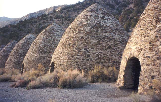
From California 178 between Trona and Panamint Springs on the west side of Death Valley National Park take Wildrose Canyon Road into the mountains. Drive about 9mi along this mostly dirt road to the junction with Emigrant Pass Road. At this junction continue along Upper Wildrose Canyon Road, passing Wildrose Ranger Station. Alternatively, from Emigrant Junction on California 190 take Emigrant Pass Road south for about 21mi to the junction with Wildrose Canyon Road. Turn left onto Upper Wildrose Canyon Road, passing the Wildrose Ranger Station. From the junction drive east on the paved Upper Wildrose Canyon Road, climbing as you ascend into the high country that forms the west wall of Death Valley. After 7mi you pass the beehive-shaped Charcoal Kilns that are worth stopping to see. The asphalt ends just beyond the kilns and the road gets very steep and rough. After another 0.7mi you pass Thorndike Campground (8 sites) and, 1.6mi beyond the kilns you come to the end of the road at Magohany Flat Campground (36o13.81'N 117o4.11'W and an elevation of 8133ft), the trailhead for this hike.
Hike
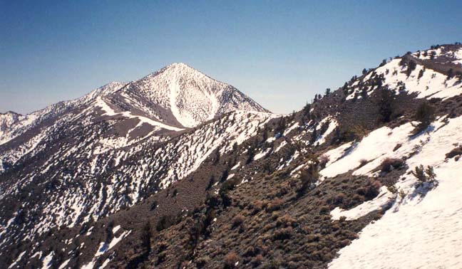
From the Mahogany Flat trailhead (36o13.81'N 117o4.11'W) you can see the switchbacking dirt road that climbs to the relay stations atop Rogers Peak. Instead of following that crestline, the well-marked trail contours around to the east of Rogers Peak, gradually climbing through sparse pine forest. After about 1mi you round a ridge and catch your first view of the distant Telescope Peak. You can also clearly identify the ridgeline that you will ascend and then follow to the summit. Down below you on the left is the Middle Fork of Hanaupah Canyon; it leads away to the east down to the salt flats in the bottom of Death Valley. Perhaps you will be able to discern Badwater in the distance.
|
|---|
| Charcoal Kilns |
From this viewpoint, the trail continues to climb over increasingly barren terrain toward a 9630ft saddle in the main north/south ridge. This broad saddle is 2.2mi from the trailhead and has a clump of trees known as Arcane Meadows (36o12.80'N 117o5.42'W). From here the trail contours to the west of two moderate summits in the main ridge, the 9980ft Bennett Peak and another unnamed peak (9695ft). Here there are a few trees and the snow usually lies late in the year. Mostly the trail is rocky. Soon this circumnavigation is complete and you arrive at another broad saddle (36o11.95'N 117o5.44'W and elevation 9530ft) with great views to both the east and the west. Below you to the west Jail Canyon stretches off toward its junction with Panamint Valley. From this saddle, you continue the gradual climb up the crest of the ridge with the summit block now clearly in your sights. Ancient bristlecone pines begin to appear above the 10000ft elevation. About the same point the ridge steepens rather abruptly and you start climbing through rocky, wooded terrain. Here the snow lies until quite late in the year. Approaching an elevation of 11000ft, the steep climb abruptly ends as you attain the summit ridge. It is a short and easy walk along the ridge to the summit of Telescope Peak (36o10.21'N 117o5.36'W and an elevation of 11049ft). Your time for the 7mi hike from the trailhead to the summit will depend on many factors, including the extent of the snow. In the absence of deep and extensive snow it should take about 4hrs.
 | 
| |
|---|---|---|
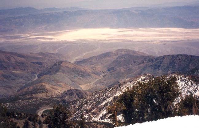
| First view of Telescope Peak | Death Valley from the summit |
On a clear day, the views from the summit are spectacular. On the east the salt flats and forbidding deserts of Death Valley, with the lowest point in the United States, Badwater at an elevation of -280ft. Further to the north you should be able to make out the oasis of Furnace Springs. And, on the distant eastern horizon, you may be able to see the summit of Mount Charleston. To the west, Panamint Valley; beyond that, the spectacular snow-clad peaks of the Sierra Nevada dominate the horizon. Highest among these is the highest mountain in the contiguous United States, the 14494ft Mount Whitney. It is remarkable to be able to view both the highest peak and the lowest valley from the same vantage point. Closer to the summit, it is clear that travel to the south along a continuation of the north/south ridge is very rough and trailless.
Return the way you came. The descent should take about 3hrs, again
depending on the snow conditions.
Last updated 12/1/00.
Christopher E. Brennen