ADVENTURE HIKES AND CANYONEERING
IN THE SOUTHWEST
© Christopher Earls Brennen

|
|---|

|
Hike D9. South Fork Taylor Creek
- Hiking time: 2 hours
- Estimated hiking distance: 3.2 miles
- Elevation gain: 300 feet
- USGS Topo Maps: Kolob Arch
- Difficulties: None
- Special equipment: None
-
ACA Rating: 1A II

Characteristics
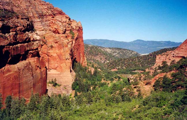
The northwestern part of Zion National Park, the Kolob Canyons Section, is quite separate from the rest of the park and thus receives only a fraction of the visitors who crowd into Zion Canyon itself. Yet the Finger Canyons of the Kolob are magnificent, with massive great red cliffs, arches and canyons of Navajo sandstone. The three forks of Taylor Creek are all accessible from the single road that climbs up into the canyons from the flatland below and each is worthy of exploration. Indeed, they are so convenient that this adventure is included here not only because of its simplicity and beauty but also because it can be enjoyed anytime you have a couple of hours to spare while travelling the busy Interstate 15 just outside the park. The hike up into the South Fork of Taylor Creek is easy, mostly trail leading to a dramatic narrows where the canyon width decreases to about 6ft with sandstone walls towering high overhead. Along the way, you get to enjoy a verdant canyon bottom with abundant wildlife. And when I did the hike I saw no-one else the entire time.
Trailhead
Leave Interstate 15 at the Kolob Canyons exit (exit 40) about 17mi south of Cedar City, Utah, and pause at the Visitors Center just beyond the end of the off-ramp. The trailhead for this hike (37o27.32'N 113o11.16'W) is a parking area just before a hairpin bend 3.1mi from the Visitors Center along the single road into the Kolob Canyons Section of Zion National Park.
Hike
From the parking area (37o27.32'N 113o11.16'W and elevation 5950ft) cross the road to the evident use-trail that drops down from the road into the canyon on the north side of the hairpin. This well-worn trail is easily followed as it winds through the bushes in the canyon bottom to the north of the stream bed. After several hundred yards you begin to climb a huge earth dam caused eons ago by a huge rockslide that filled the canyon and is now overgrown with Gambel Oak and other canyon bottom vegetation. You climb about 250ft and, in the process, get some marvellous views back down the canyon.
|
|---|
| South Fork Taylor Creek |
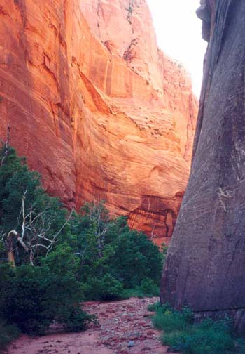
About 30min from the start you reach the top of the earth dam. After the rockslide occurred, a large canyon-filling lake was formed behind it. The ancient lake (37o27.23'N 113o10.40'W), which geologists refer to as Lake Beatty, then filled with sediment, creating the modern environment, a lovely wooded and flat meadow that provides a delightful walk. Keep an eye out for the abundant wildlife that lives in this meadow. I saw a group of wild turkeys and a large buck deer bounded across my path. The flat meadow contrasts with the massive vertical walls on the sides that gradually close in as you progress eastwards. Note that, for some reason, the southern or left wall is black in contrast to the bright red northern wall. Just east of the rockslide, the trail passes a grassy hollow and then proceeds east through the meadow before petering out in the flat streambed. You then continue upstream in this streambed which mostly runs alongside the base of the wall on the right side.
 | 
| |
|---|---|---|
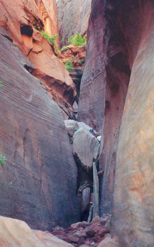
| Canyon closing in | Second Chockstone |
Finally the walls narrow to about 15ft apart and progress upstream is suddenly blocked by a huge chockstone (37o27.11'N 113o9.77'W). This chockstone is 1.6mi and 50min from the start. You may choose to turn around here for you cannot get much further even by climbing. However, it is relatively easy to climb around the left side of the huge chockstone. At the top the way is blocked by a rockslab that is a little harder to ascend. Then you can only progress about 20yds further before the canyon narrows still further to about 6ft and the way is blocked by a second chockstone that is much more difficult to surmount. I turned around here.
The return hike across the meadow is another pleasure.
As you are hiking down the creekbed about 100yds
west of the first chockstone, you may
notice a fun overhang climbing route part way up the southern wall. If you
have time and if you brought your climbing gear this would be an
enjoyable challenge. Though overhanging the route is well bolted and has lots
of big handholds, footholds and ledges. If you pass on this you will
get back to the parking area
(37o27.32'N 113o11.16'W)
about 2hrs after starting out.
Last updated 7/1/01.
Christopher E. Brennen