ADVENTURE HIKES AND CANYONEERING
IN THE SOUTHWEST
© Christopher Earls Brennen

|
|---|

|
Hike K3. Tar Creek
- Hiking time: Option one 8.7 hours; Option two 10 hours
- Estimated hiking distance: Option one 9.3 miles; Option two 7.6 miles
- Elevation gain: Option one 1780 feet; Option two none
- USGS Topo Maps: Fillmore
- Difficulties: 2 or more rappels, 2 swims, much bouldering and wading.
- Special equipment: 190ft rope, 190ft recovery cord, rappelling equipment, 40ft webbing, 2 rappel rings
-
ACA Rating: 3B III

Characteristics
This is a spectacular adventure that descends the rugged and tortuous Tar Creek and then has two options. The first phase, the descent through the Tar Creek ravine, requires two or three rappels and two or three swims through deep pools. There is also much route finding between, through and sometimes under huge boulders and tortuously sculpted rock before you arrive at the junction with the Sespe. Option one is to hike back to the starting point along a rough but easily followed trail. Option two, which requires a car shuttle, is to descend the larger but also difficult Sespe Gorge to where it exits the mountains north of Fillmore in Ventura County, California. This continuation of the adventure requires you to find your way through fields of more huge boulders and finally through the spectacular Devil's Gate. Option one is a day hike; option two is a very long day-hike and perhaps better done as an overnighter. There are a number of good campsites in Sespe Canyon. Both options are best undertaken during warm weather since you will spend much of the time soaking wet. Late in the summer Tar Creek may dry up and lose some of its verdant beauty. When this happens the pools can become quite stagnant and the swimming less attractive. Consequently the hike is probably at its best on a warm spring or early summer day when the water is flowing but you can dry out relatively quickly.
Trailhead
A car shuttle is required for option two of this challenging adventure hike. Thus one, two or more vehicles should be driven to the town of Fillmore, northwest of Los Angeles. From Highway 126 turn north on Highway 23 and proceed straight through a series of stop signs. After 1.5mi you will come to a tee junction where you turn right though, because of the way the roads bend, you are, in effect, proceeding straight on. You are now on Goodenough Road, driving past citrus groves. After 3.7mi you reach the end of the normal road at a junction at 34o26.91'N 118o55.35'W, where the left fork is gated private property and the right fork climbs steeply. It is signposted as Forest Road, 6N16.
The route proceeds up the right fork but for option two you should back up about 20 yds and identify a straight dirt walkway along the northern edge of a citrus grove that runs down to the river on the left side of the road. This is the route option two will follow back to the road from the river at the end of the hike. Park one car just off the right side of the road directly in line with this pathway.
Then, in the other vehicle(s), proceed up the right fork that is just ahead (the Squaw Flat Forest Road, 6N16) as it climbs the east wall of a side canyon called Little Sespe. About 2.3mi up this road you will pass a set of oil pumps. Proceed straight on where a dirt road branches off to the right. Then after 3.3mi you will pass through Oak Flat where there are Forest Service structures. Again you proceed straight on where a road branches off to the right. Finally, 4.7mi from the start of 6N16, you will arrive at a broad open parking area from which dirt roads proceed in several directions. This is the trailhead (elevation 2500ft); park here at 34o28.82'N 118o55.03'W.
Hike
From the trailhead (elevation 2500ft) follow the dirt road going northwest. After passing a locked gate and climbing briefly, this begins a descent into the Tar Creek drainage with good views northwest into Sespe Canyon. After 1.5mi the road passes a beehive farm and then degenerates into a trail that, after another 1.0mi arrives at the crossing of Tar Creek at 34o29.41'N 118o55.70'W and an elevation of 1920ft. The trail then climbs up the other side of the creek following a disused dirt road and eventually descends to Sespe Creek north of Tar Canyon. That trail is the return route for option one and it is wise to fix it in your mind for later.
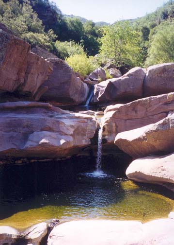
Here, at the Tar Creek crossing, the off-trail hike starts and you begin to boulder hop down Tar Creek itself. This is a beautiful and initially gentle stream that is full of life. As you begin to encounter deeper water, look for the harmless water snakes that are abundant here and for the turtles that inhabit some of the larger pools. After about 20min of easy hiking, you arrive at the top of the Tar Creek Cascades (at 34o29.54'N 118o55.99'W), a magnificient series of small waterfalls and polished rock pools. On a hot day this is a great place for a swim. The first few steps in the cascade can be downclimbed on the left but you will probably elect to wade through the last broad pool.
Downstream of the cascades, the going rapidly gets much harder. You will need to find your way round, over and under huge boulders that fill the canyon; I recommend that you stay toward the left. At the end of this boulder section there is a large pool that, in turn, presages the first dramatic obstacle on this adventure. Just beyond it at 34o29.68'N 118o56.21'W the stream plunges down into a deep ravine cut in the flat rock stratum on which you are standing. The water falls about 60ft into a deep pool at the bottom of the ravine. These are the upper Tar Creek Falls and should be reached about 1hr 50min from the start.
 | 
| |
|---|---|---|
| Tar Creek cascades | Upper Tar Creek Falls |
There are two ways of descending into the ravine. There is a use-trail that you can follow around the right lip of the cliff to a point where you can descend to a ledge that switchbacks to a point where the remainder of the descent can be made down the bare rock. A simpler and more exciting way to descend is to rappel down on the left of the waterfall using a convenient anchor between two boulders near the lip of the cliff.
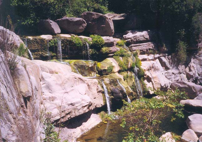
After the descent, you face a rugged, obstacle filled route along the bottom of the ravine. Though the first large pool at the base of the waterfall can be bypassed, there is no avoiding the swim through the second pool immediately downstream of the first. The discharge from this second pool falls about 25ft into the third pool. However, these falls can be negotiated on the left first by downclimbing a 10ft slot and then bypassing the third pool by climbing along a high ledge on the left side of the canyon. For the next 200yds the canyon presents a series of obstacles consisting of small waterfalls, rock ledges and pools with vertical cliffs on both sides. The going is slow but fun on a warm day.
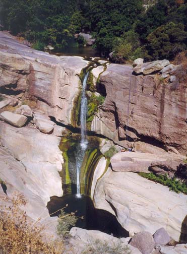
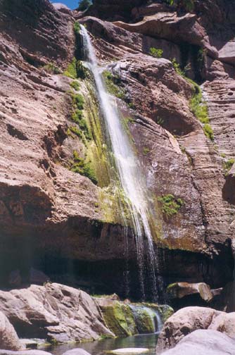
This section ends in a huge vertical drop-off about 30yds wide that you should reach about 3.5hrs from the start. The stream disappears over this cliff at 34o29.61'N 118o56.40'W and plunges about 160ft into a large, deep pool. From the top of the drop-off the remaining stretch of Tar Canyon and its junction with Sespe Canyon are readily visible. There are two possible routes for the descent of the big waterfall. The more adventurous is a spectacular 160ft rappel down the big face just to the right of the waterfall. There is an excellent anchor around a rock trapped under a large boulder just a few feet back from the edge of the cliff. When the water is flowing fully this is a great rappel. The best place to dismount is at a broad ledge about 8ft above the pool at the bottom. You can descend from the ledge to the right of the pool.
The second and less dramatic method of descent is to follow a use-trail that leads along the lip of the cliff to the right. If you follow this as far as you can easily go, there are several rocks that can be used as anchors to rappel down about 70ft through the bushes into a steep gully on the right. Once in the gully itself, two more rappels are needed to descend to the edge of the big pool at the bottom of the main waterfall.
 | 
| |
|---|---|---|
| Lower Tar Creek Falls | Falls in Lower Tar Creek |
You should reach this point about 4.5hrs from the start. It is an idyllic place to stop for lunch and a swim. Few people ever manage to penetrate this far into the wilderness and so it remains a special place.
The remaining short section of Tar Canyon between the big waterfall and Sespe Creek is slow going, consisting of an accummulation of huge boulders. Initially it is easiest to stay as far right as possible. Closer to the Sespe, a number of old dry channels of Tar Creek will become evident on the right. We followed a small dry channel in the middle that allowed us to reach the Sespe fairly easily. You should arrive at this junction with the Sespe (at 34o29.49'N 118o56.60'W and elevation 1280ft) about 5hr 45min from the trailhead having travelled only about 3.7mi in that time. At this point the two options proceed in different directions.
Option One:
To find the trail back to the start, proceed right up the Sespe. There is no need to cross the river, because you can find your way around and over the few huge boulders you encounter on the west side. After just 15min you will come to several unofficial campsites on the right bank of the river, with sandy areas for bedding down and substantial fire rings. Large swimming holes nearby make this an attractive spot to spend the night.
The trail back to the start begins immediately behind these campsites at 34o29.52'N 118o56.68'W and is marked by several ducks. It follows the route of an old road built to service the long gone oilwells along this part of the Sespe. Above the river, there are two long traverses first to the left and then back to the right. This brings you to a steep section littered with rockfalls before you go through a cutting in a projecting ridge. Just before the cutting there is a good but partial view of the big waterfall in Tar Creek. Beyond the cutting the trail climbs and then descends to the Tar Creek crossing that you passed earlier in the hike. It should take 1hr 45min to climb the 3.1mi from the Sespe to the Tar Creek crossing (at 34o29.41'N 118o55.70'W) and another 1hr to hike the 2.5mi back to the trailhead.
Option Two:
The junction of Tar Creek with the Sespe is a broad gravel flat and you should cross the river to begin your progress downstream along Sespe Creek. Just below the junction, the going deteriorates dramatically and you enter a particularly difficult section with huge, purple boulders blocking the way at every turn. We made our way down on the right but this involved much route finding and some swimming. A large red cliff on the left marks this section and, once past this cliff, the way gets progressively easier. About a mile downstream, it is possible to make significantly faster progress by crossing and recrossing the river, travelling on the flatter benches and avoiding the fields of large boulders. Here, in many places you will see tar ouzing out of the ground or out of the side of the canyon and forming films of oil on the surface of the pools. This region was the site of some of the first oil wells in California and traces of those efforts still remain. About two miles downstream of the Tar/Sespe junction is a fair sized lake and from there to Devil's Gate it is easiest to travel on the right.
 | 
| |
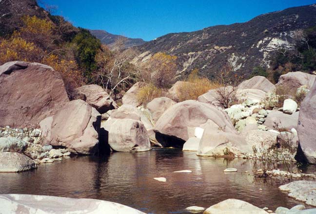
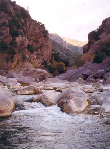
|---|---|---|
| Sespe at Tar Creek trail end | Devil's Gate from downstream |
The last major obstacle on this adventure is Devil's Gate, a narrow restriction in Sespe Canyon at 34o27.81'N 118o56.62'W. If you are in doubt about recognizing Devil's Gate, watch for a large tributary, called Coldwater Canyon, that enters on the right. The sediment carried into the Sespe by the Coldwater has created a large gravel bench just upstream of Devil's Gate. You should reach the junction with the Coldwater (elevation 850ft) about 8.5hr from the start having travelled 5.7mi in that time. About 100yds past the Coldwater, stay to the right as the canyon walls begin to steepen and close in. To find the use-trail through Devil's Gate high up on the right wall, it is necessary to climb the steep, rocky slope just before entering the Gate. There is a trail of ducks along this route; if you can find them, follow them. The trail becomes much more distinct once you have climbed the first rocky slope. It then follows the general route of the old road through Devil's Gate, built to service the oil wells mentioned earlier. Only vestiges of this road remain but the trail is not too difficult to follow and descends to the river downstream of the Gate. Incidentally, the large quantities of driftwood scattered along the trail throughout the Gate must have been deposited by an awesome flood some years ago.
Another large drainage, Pine Canyon, enters from the right just downstream
of Devil's Gate and, at this point, it is wise to find one of the many
use-trails along the broad flat bench to the right of the river. This
allows rapid progress. Then, just after the canyon turns to the right,
cross over to the left side until you reach the small, man-made
reservoir that signals the fact that you are close to the end. Just
downstream of the reservoir you may choose to follow the dirt road on
a bench on the right. This passes some private property and may require
you to negotiate a locked gate just beyond a house on the left side of the
road. Just past the gate the road divides at about
34o27.21'N 118o55.52'W. Follow the left fork that
descends to the river. Then hike along the river for about 400yds
to 34o26.89'N 118o55.61'W to
a place where two large cables in white plastic tubes are strung
overhead across the river. If you climb the left bank about 20yds
downstream of these cables, cross a narrow open field or citrus grove
and climb another steep bank you will be in the citrus grove that
is the very last part of this hike. Travel along the north side of
this citrus grove back to the first vehicle and the end of the
adventure at 34o26.91'N 118o55.35'W
(elevation 675ft). It should take a total of about
10hrs to cover the 7.6mi of option two.
Last updated 4/10/03.
Christopher E. Brennen