ADVENTURE HIKES AND CANYONEERING
IN THE SOUTHWEST
© Christopher Earls Brennen

|
|---|

|
Hike K20. Tahquitz Rock
- Hiking and climbing time: 8 hours
- Estimated hiking distance: 2 miles
- Elevation gain: 1000 feet
- USGS Topo Map: San Jacinto Peak
- Difficulties: Six pitches of technical rock climbing with a few challenging moves and great exposure in places
- Special equipment: Climbing harnesses, shoes and helmets, 200ft rope, two sets of cams, nuts, slings, quickdraws and carabiniers
-
ACA Rating: 4A III

Characteristics
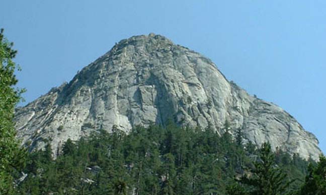
The great granite cliffs of Tahquitz Rock that loom high over the alpine village of Idyllwild in the San Jacinto mountains about 100mi east of Los Angeles were one of the birthplaces of rock-climbing in Southern California. Pioneers of the sport like Royal Robbins and Chuck Wilts honed their skills and invented new techniques on the high quality rock of this monolith. On the topograhical maps it is known as Lily Rock though everywhere it is called simply, "Tahquitz", the name of a Cahuilla Indian demon who ate people's souls. Today there are many established routes on Tahquitz and its companion monolith across the valley, Suicide Rock.
Any list of adventures in Southern California would be incomplete without at least one visit to this storied rock and we describe here one of the easiest of the technical routes that ascend the face of Tahquitz, a six pitch technical climb known as the "Fingertip Traverse". According to Glen Dawson it was the first climb he made at Tahquitz; he climbed it with Chuck Wilts who was also climbing at Tahquitz for the first time.
This is not an adventure for the novice, for it involves considerable exposure and therefore demands practiced skill at protecting a climbing route. Though the route known as "The Trough" is easier, we choose the Fingertip Traverse because, for the average climber, it is a spectacular route with some significant challenges. Fingertip Traverse is officially rated 5.3. However, the routes on Tahquitz seem very under-rated ("stiff") compared with other rock-climbing locations.
This adventure is fun at almost anytime of the year except in the depths of winter when ice and snow at 7000ft change the face of the rock.
Trailhead
From Highway 243 in the center of the village of Idyllwild, California, drive northeast up North Circle Drive. After about 0.8mi, make a right turn onto South Circle Drive and, shortly thereafter, a left turn onto Fern Valley Road, following the rather inconspicuous signs for Humber Park. After about 2mi and a switchback, you arrive at the parking loop in Humber Park (33o45.88'N 116o41.17'W). This is the trailhead for several paths into the forest. Park near the south end of the loop.
Hike
From the south end of Humber Park loop (33o45.88'N 116o41.17'W), descend to a broad, well-trodden trail and follow it southwest for several hundred yards to where a rough climber's trail heads directly up a shallow gully (usually marked by a cairn). The climber's trail follows short switchbacks as it climbs steeply toward the cliff face that looms directly overhead. You climb southeast ascending about 500ft and passing under a large log before arriving at the base of the cliff at a local feature known as Lunch Rock (looks like a sandwich about 30ft up) at (33o45.63'N 116o41.09'W). Here use-trails go around the cliff to the left and the right. For Fingertip Traverse, go right for about 100yds, to where the use-trail climbs up a groove right next to the cliff. A short way up this groove, you come to a place where there is a sizeable pine tree on a ledge about 12ft above the trail (the tree may be a mountain mahogany). Climb up to the ledge at the base of the tree and prepare for the technical pitches ahead.
 | 
| |
|---|---|---|
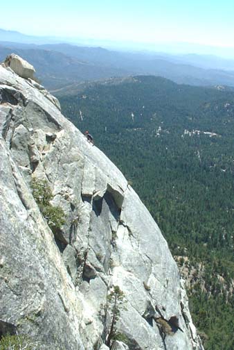
| Tahquitz Rock | Friction climb on last pitch | |
(Photos by Dean Tower) | ||
The first pitch, which is really just class 3, begins about 20ft to the left of the tree and climbs about 80ft up an easy gully to a stout tree in a recess at the top of the gully. This tree is the belay point for the second pitch (about 100ft) which, using the tree, climbs up onto the arete to the left of the recess and then follows a crack up to a sizeable platform with a number of bushes. Climb a crack at the back of this platform to access a large spreading tree on another substantial ledge about 15ft above the platform and slightly off to the right. This tree is the belay point at the top of the second pitch.
The third pitch (about 120ft) presents a significantly greater climbing challenge; from the tree anchor at the top of the second pitch proceed left toward a corner with a crack and then either climb the corner or move onto the face just to the left for some nice face-climbing. The first move here is the hardest; after about 10ft the climbing becomes easier and you proceed straight up to a series of broken ledges that take you to the left for about 15ft. Here you move around to the left onto a face with considerable exposure and arrive at the section for which this route is named. It is a sloping horizontal crack which has excellent handholds; proceed laterally for about 15ft using these handholds and with your feet against the sloping rock below the crack. The belay station at the top of this third pitch is at the end of the traverse where the crack widens into a small ledge and additional security is provided by a gnarled tree growing on the ledge. From this perch, the short fourth pitch (about 50ft) proceeds almost straight up over broken slabs to a broad secure ledge known as Lunch Ledge.
The climb from Lunch Ledge to the top could be done as a single pitch, but, to avoid excessive rope drag near the top, is better done as two pitches. In that case, the short, 40ft fifth pitch climbs straight up from Lunch Ledge veering to the right to access a series of broken slabs. The first move climbing above Lunch Ledge is probably the most difficult of the route but once that is accomplished, the climbing is short and easy up to a recess that contains the next belay station, a gnarled tree at the back of the recess. On the sixth pitch (about 100ft) climb up to the right out of the recess onto an inclined face and follow a crack up to the left. This crack transitions onto a steep and quite smooth rock face with huge exposure. It becomes horizontal but very narrow and you must tightrope along this ledge crack to a very small tree growing out of the crack. The tree provides both an anchor point and marks where you should leave the crack and proceed directly up the rock face, friction-climbing the last 50ft to the top of the route. A third of the way up this friction climb you pass an old bolt installed in the rock. The top of the climb (33o45.63'N 116o41.01'W) is a broad shoulder on the top of Lily Rock where many other routes also terminate. Several large boulders provide ample anchor opportunities. The view from here is spectacular.
The descent is best accomplished by hiking up the spine of the ridge
behind the belay point heading for the summit of the monolith some
distance to the east. As you hike stay close to the edge of the cliff
on your right until you arrive at a point where you can visualize a steep
un-roped climb down a series of ledges to the bottom of the rock. You
should reach the
forested bottom in a shallow gully. From there follow the use-trail
down the slope staying close to the base of the cliff. After about
40min of descent you should arrive at the point where Fingertip
Traverse began. From there you retrace your steps down the use-trail
to Humber Park.
Last updated 12/1/02.
Christopher E. Brennen