ADVENTURE HIKES AND CANYONEERING
IN THE SOUTHWEST
© Christopher Earls Brennen

|
|---|

|
Hike D8. The Subway
- Hiking time: 7 hours
- Estimated hiking distance: 9.5 miles
- Elevation gain: 380 feet
- USGS Topo Map: The Guardian Angels or Zion National Park Topographical Map
- Difficulties: Some route finding, several short rappels, much scrambling and bouldering, some swimming, flash flood danger.
- Special equipment: 70ft rope and rappelling gear, dry (waterproof) bags.
-
ACA Rating: 3B III

Characteristics
Zion National Park in southwestern Utah is one of loveliest places on earth. But if you visit it in the usual way, by driving up into the main canyon where it opens up into the desert and if you do not venture far from the road you will only have seen a fraction of this beauty. Beyond the asphalt, lie magnificient sculptured canyons, luxurious grottoes and awesome carved sandstone ravines that can only be reached on foot and, sometimes, only by swimming and rappelling. This is a mecca for canyoneers and the adventure hikes in Zion must rank as among the best in the world. Many adventure hikers would rank ``The Subway'' as their favorite.
The Subway is the name given to a section of canyon in the Left Fork of North Creek near the western boundary of Zion National Park. The name derives from the fact that along one stretch of the Left Fork where it has carved a deep slot canyon into the red sandstone, the bottom of the slot opens up into a circular, tube-like shape. But there is much more to the Subway than just this odd feature. The hike begins at an elevation of 7000ft, high on the Markagunt Plateau that surrounds Zion except on the south. It descends through spectacular carved sandstone scenery before dramatically climbing down into the slot canyon. There the adventurer is treated to a marvellously varied sequence of natural sculptures and physical challenges. The hike can be completed quite easily in a day.
A permit is required even for day hikes through the Subway. These may be obtained a day in advance from the Visitors Center in Zion National Park. Advance reservations can be made by telephone.
Trailhead
This hike requires a car shuttle. It is probably most convenient to overnight in Zion National Park. If you do so then you can reach the trailhead by driving back out of the Park and west to the town of Virgin about 14mi away. There you turn north on the Kolob Reservoir Road and travel 8.5mi to the Left Fork Parking Area on the right side of the road (37o17.14'N 113o5.78'W). Leaving one vehicle in that sandy parking area, continue another 7mi up to the Wildcat Canyon Trailhead (37o20.38'N 113o4.52'W and elevation 7000ft), located a hundred yards or so down a dirt road on the right. Parking the second vehicle there.
Hike
The trail proceeds eastwards over a gentle, partly wooded mesa. After about 1mi, the Hop Valley connector trail comes in on the right but you continue on for another 200yds or so to the junction with the trail to Northgate Peaks (37o20.56'N 113o3.43'W). Fork right and follow the Northgate Peaks trail for about 50yds to the top of a small rise. A use-trail forks off to the left and you follow this to the top of a broad expanse of slickrock. Follow the series of ducks that lead down the slickrock while angling to the right. At the bottom of the slope, the ducks lead to a well-travelled trail that enters the brush and trees alongside a small creek. This is a pretty section with luxurious ferns contrasting with the raw slickrock higher up. After several hundred yards, the trail emerges again onto the slickrock and the route down to a creek crossing is again marked by ducks. You should reach this stream crossing at an elevation of about 6300ft about 35min after leaving the trailhead. The trail on the other side of the creek continues to be well-ducked as it crosses some rough rocky ground and traverses over toward Russell Gulch. Just before the Gulch you arrive at a section of steep descent that leads to the Russell Creek crossing (2.6mi and 1hr from the trailhead at 5800ft).
 | 
| |
|---|---|---|
| Approaching Slickrock Saddle | Slickrock Bowl |
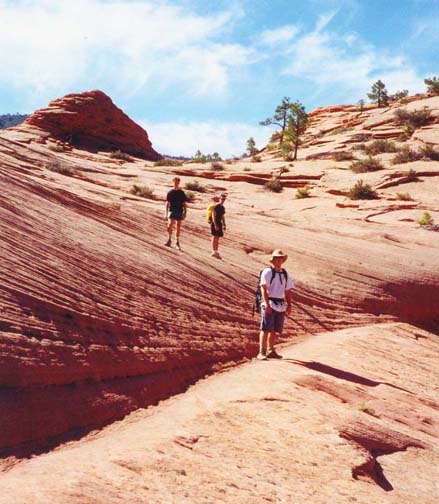
On the other side of Russell Creek, the route climbs the slickrock toward a bare rock saddle where there are two prominent hoodoos. Only a few ducks mark this section but it is hard to miss the saddle. Once the saddle is broached, there is a spectacular view south into a broad slickrock bowl. Before descending, it is wise to pick out the trail in the distance as it snakes through the trees on the far side of the bottom of the bowl. The route descends straight down into the bowl following the ducks and continues contouring through the woods toward the manzanita slopes high above the left side of Russell Gulch. At this point the Gulch is out of sight in a gorge off to the right. As is the case throughout this hike, the trail is well worn and easily followed; it is particularly important not to lose the main trail during the next stretch.
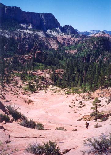
About 3.7mi into the hike at an elevation of about 5600ft, the trail quite suddenly arrives at a spectacular viewpoint high above the junction of Russell Gulch and the Left Fork of North Creek. The view here is quite awesome; you can look both upstream and downstream into the vertically walled Left Fork ravine and, simultaneously upstream into the canyon of Russell Creek. It is hard to visualize how you will be able to make the descent into the canyon below you. However, just around to the right, you will find the top of a steep and narrow gully by which to make the descent with some Class 3 downclimbing. In this gully you drop over 200ft, arriving at the bottom beside a large pool in Russell Gulch. The confluence with the Left Fork (37o19.07'N 113o2.44'W) is just 20yds downstream at an elevation of about 5300ft.
This marks the start of a beautiful transit through the scenic and wondrously sculpted gorge of the Left Fork of North Creek - known throughout the hiking world as ``The Subway''. In contrast to the reflected heat of the slickrock higher up, it is cool here in the canyon depths and you should take your time over the next few miles to truly enjoy this marvellous canyon. About 200yds from the Russell Creek junction, a small boulder field leads to the first serious obstacle, consisting of a large canyon-blocking boulder forming a 15ft drop. The easiest descent is to chimney down the gap on the right between a huge boulder and the canyon wall. A large log in the chimney currently allows relatively easy descent by straddling and sliding down it. A short distance further on the canyon closes in and you arrive (4.3mi from the start at an elevation of 5240ft) at two deep pools in a section of canyon only about 6ft wide. At the ends of the pools (30ft and 15ft long) are small cascades that are easily negotiated. However, both pools can be deep enough to require swimming. There is a sunny little beach just downstream of these pools that you will reach about 2hrs into the hike; it is a fine spot for lunch.
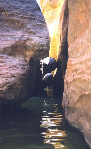
Just about 100yds further and you arrive at a more challenging and interesting obstacle where the stream flows through a very narrow slot only about 2-3ft wide. The less challenging route is to bypass this slot by climbing to a ledge on the left about 12ft above the stream at the entrance to the slot. Though somewhat wet and slippery due to water seepage, this ledge can be used to travel (crawl) downstream to the end of the slot; there you can descend to the canyon floor by rappeling or downclimbing a tricky and steep rockslope (a conveniently placed tree provides a good anchor for the recommended 30ft rappel). However, it is more fun to take the direct route and proceed down the narrow slot in which the water is initially only a few feet deep. However, you quickly arrive at a small two-stage waterfall by which the water falls into a small cavern with chest deep water. The waterfall can be downclimbed using several convenient footholds. Downstream of the cavern you may need to swim across several pools and through two very narrow restrictions - about 18in wide. The second restriction has two round chockstone boulders jammed between the slot walls, one above the other. The best way through is to place your pack on top of the lower boulder and then slide under it almost completely underwater, retrieving the pack after you emerge on the other side. The end of this intriguing obstacle is just beyond the chockstone boulders.
 | 
| |
|---|---|---|
| Chockstone boulders | The Subway |
Downstream the canyon widens again but the walls seem to grow in height. About 0.3mi from the chockstone boulders (and 4.9mi from start), the canyon again narrows to a slot and you arrive at Keyhole Falls, a 10ft drop easily recognized by the hole in the rock just above the lip on the left. Bolts in the rock on the right provide a convenient anchor for the rope or webbing used for the small downclimb or rappel. You should reach this 5250ft elevation about 3hrs 15min into the hike.
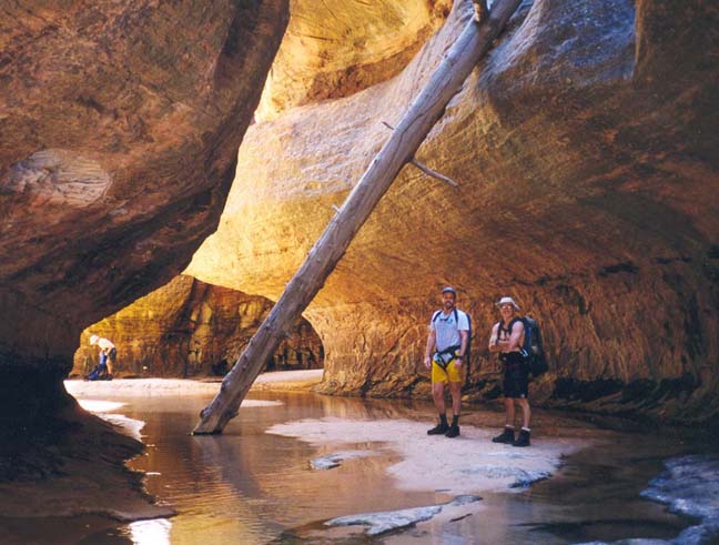
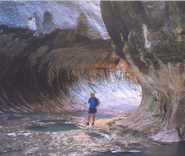
The Keyhole Falls lead to a narrow slot that continues for about 50yds with some curious geometric shapes in the rock. It then widens, the walls steepen and the overhangs and ledges characteristic of a subway appear. This spectacular subway shape (37o18.59'N 113o3.10'W) proceeds for several hundred yards until you arrive at another place where the stream drops into a narrow slot in the canyon bottom as the canyon makes a right turn. A series of contorted pools in the bottom of this slot mean that it is easier to descend a short distance downstream of the falls by following the prominent ledge on the left to a place where bolts have been installed on the sloping rockface. This is the longest rappel on the hike, a descent of about 35ft that requires a 70ft length of rope for a safe double-rappel. Here at an elevation of 5200ft you will be about 4hrs from the starting trailhead.
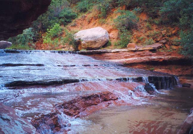
There is a short but magnificent section of subway downstream of the rappel before the canyon opens up into a more conventional shape. This marks the end of the technical descents. The rest of the hike only requires negotiation of boulder fields. In the next half mile there are a series of beautiful and gentle cascades over red sandstone. This rock surface is less slippery than one might guess at first sight and it is relatively easy to walk down the water-covered rock. In several places it is necessary to follow the use-trails through the vegetation on the left in order to circumvent larger falls formed by boulders. The canyon bottom gradually becomes more benign and soon the use-trail is almost continuous, mostly following the right side. There are a number of nice swimming holes along the way that can provide a delightful refuge from the summer heat.
 | 
| |
|---|---|---|
| The Subway | Red stone cascade |
The next challenge is to recognize where to
begin the climb out of the canyon up the steep right wall. There
are some faint trails where others have begun the ascent too soon and
you need to avoid following these.
It is useful to look for
two tributary streams that enter on the
right. Just beyond the second stream, you should notice a prominent black
lava outcropping high above you on the right rim of the canyon and from
the bottom you should be able to spot
in the recess just before the prominent outcropping
one of the few breaks in the upper cliff that could allow escape from
the canyon.
The beginning of the ascending trail
(37o17.29'N 113o5.22'W) is about
8.3mi from the start of the hike at an elevation of 4700ft.
It proceeds straight up a shallow gully
before steepening, traversing to the left and proceeding
through the aforementioned gap in the cliff. The climb to the plateau
is about 400ft. Once at the rim, it is an easy and relatively flat
hike of about 0.8mi along a well-worn trail
back to the lower trailhead
(37o17.14'N 113o5.78'W and elevation
4900ft) and the parking area. The total
length of the hike is about 9.5mi and takes about 7hrs.
Last updated 9/9/99.
Christopher E. Brennen