ADVENTURE HIKES AND CANYONEERING
IN THE SOUTHWEST
© Christopher Earls Brennen

|
|---|

|
Hike D11. Zion's Spry Canyon
- Hiking time: 7.5 hours
- Estimated hiking distance: 3 miles
- Elevation gain: 820 feet
- USGS Topo Map: Springdale East or Zion National Park Topographical Map
- Difficulties: 13 rappels, one measuring 150ft; some downclimbing and deep wading; some flash flood danger.
- Special equipment: Two 50m ropes, 50ft webbing, several rappel rings, harnesses, helmets, rappeling gear and dry bags (wetsuits in colder conditions).
- Permit: Obtain permit from Backcountry Desk in Zion National Park Visitor Center.
-
ACA Rating: 3B III

Characteristics
A classic Zion canyon, Spry provides a lovely, moderate canyoneering adventure with 13 rappels, a number of downclimbs and several deep slot wades, one up to chest high. Despite these wades you will not need a wetsuit except on cold days in the spring or fall. Spry is located close to the Zion-Mt.Carmel Highway which thus allows for a convenient and short car shuttle. The ascent to the pass that accesses the top of Spry Canyon has some 4th class slickrock sections for which sticky-rubber-soled shoes are very valuable. In the summer it can be very hot both during the ascent and during the last part of the descent so this canyon is best on a cooler spring or fall day.
Trailhead
This hike requires a short car shuttle. First drive north into Zion National Park and 0.5mi past the turnoff that goes to the Lodge and the inner canyon. There the road switchbacks via a bridge over Pine Creek. Leave the return vehicle in the turnoff on the left just before the bridge (37o13.01'N 112o57.93'W) and then, in the other vehicle, proceed up the Zion-Mt.Carmel Highway and through the long tunnel. Emerging from the tunnel, drive 0.2mi and park in the small turn out on the outside of a left hand turn (37o12.89'N 112o56.28'W, elevation 5120ft).
Hike
From the pullout (elevation 5120ft), continue east along the road for 200yds to where the broad wash of Pine Creek crosses under the road. Leave the road and hike north up the sandy bottom of Pine Creek. Continue up the wash for 0.6mi or 20min to a where the canyon narrows. You should find a place where there is a steep but slight slickrock gully on the left at 37o13.41'N 112o56.29'W and an elevation of 5210ft. This exit point is often marked with a cairn. Climb up the slight gully which angles off to the northwest as you ascend and flattens out onto a broad bench. Follow the bench north for about 60yds and proceed into the obvious slickrock bowl on your left. Ascend the bowl toward the right side using a steep, 4th class indent. At the top follow a small flat bench around to the left and, at a vertical wall, veer right and ascend another steep indent to reach the saddle between Deertrap Mountain off to the north and the East Temple to the southwest. This saddle (37o13.63'N 112o56.65'W, elevation 5950ft, 1.1mi and 1hr from the start) is a good place to pause and get your bearings. To the east southeast you will see the deep gorge between the East Temple and Twin Brothers that is Spry Canyon and the route of this hike. Also, off to the northwest you should be able to see the gap between Twin Brothers and Deertrap Mountain that leads to Employee Canyon. The views in all directions are marvellous and worth taking a break to enjoy.
|
|---|
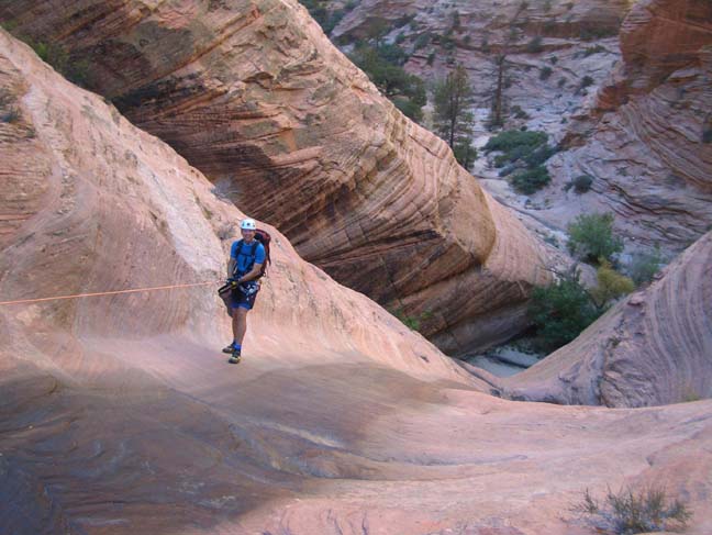
| First rappel (150ft) in Spry Canyon
|
Next you need to drop down into the gully directly to the west but the steep slickrock requires a short diversion. Hike about 100yds north to where the gully is much shallower and descend there. Then follow the gully downstream, bypassing one steep drop by a brief bypass on the right before joining the main wash of Spry Canyon just before it enters the gorge between the East Temple and Twin Brothers (elevation 5740ft, 1.4mi and 1hr 40min from the start). Hiking down this sandy wash is easy going. Then about 2hrs from the start you will arrive at the top of a 150ft rappel down sloping slickrock. The anchor bolts are on the left side of the lip and there is one pothole to avoid near the bottom. The floor may also be waterfilled but a narrow ledge just before the bottom allows you to keep your feet dry just a little longer.
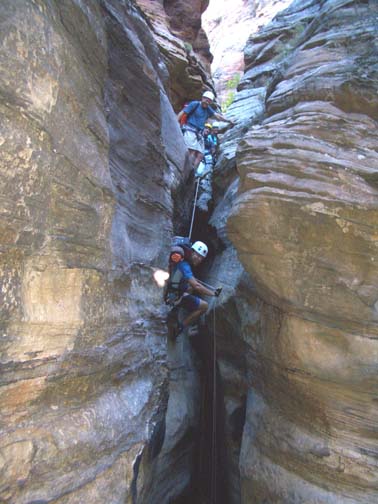
More sandy wash follows with some lovely meadows and a little bushwhacking in places. Then, about 2hr 40min from the start, you come to the first narrow slot that begins with a 15ft rappel from a tree anchor on the right. This is immediately followed by a 10ft rappel drop into a dark, covered slot with an old stump as the chockstone and anchor. Here you will have to wade through the pool in the bottom of the slot. It is then just a short walk to a 20ft rappel into a very narrow slot with water though you may be able to stem your way across this. This is followed by a 30ft rappel through a narrow gap from bolt anchors on the right wall that are a little difficult to reach.
 | 
| |
|---|---|---|
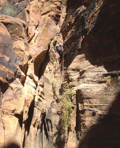
| Fourth rappel (20ft) in Spry | The sixth rappel (90ft) (Photo by Ira Lewis) |
Here, about 3hr 40min from the start, the canyon widens and descends rapidly down some ledges on the left of the watercourse to the top of a dramatic drop into a deep slot. The anchor for the 90ft rappel into this vertical slot is at the end of the ledges on the left. Try throwing the rope (or rope bag) over to the left of the slot in order to avoid the rope (or rope bag) ending up in a pothole that is on the far side of the slot at the bottom. The exit from the slot is just downstream and has a neat divide near the end. Just a few yards downstream the watercourse turns sharp right and you rappel down a narrow slot using a webbing anchor around an overhead chockstone. It is a 70ft drop into a small pothole/ledge, the exit from which is a 45ft rappel using a log across the narrow slot exit as the anchor. This accesses a larger sandy clearing from which the streamcourse exits through a dramatic narrow slot with a spectacular view. Bolts on the left wall of this slot exit anchor a short 20ft rappel down to a shallow pool that should be continued with another 15ft drop down to yet another small sandy area.
You should reach this point about 4hrs 40min from the start and it is a good place to stop for a break since the rappels continue without pause. The route of the canyon is turning southward as it prepares to exit the gap between the East Temple to the east and Mount Spry to the west. This is the canyon exit that is visible from the Zion-Mt.Carmel road on the other side of Pine Creek Canyon; indeed you should soon be able to glimpse that road through the narrow canyon openings. Continuing downstream the canyon jogs right through this sandy area and then turns abruptly left. Here there is a 60ft rappel down into a vertical slot from a bolt anchor over on the right wall (though there is another anchor about 20yds away along a very steep ledge on the right side of the top of the slot; the very exposed traverse over to that anchor is not recommended). The 60ft rappel deposits you in a small, mucky pool that can with some agility be avoided. Still in the slot, this places you at the top of a steep and very narrow 15ft slide down into a larger pool that cannot be avoided. The wade is usually about chest deep and leads to yet another steep and narrow slot perch after which the canyon finally opens up. However, the exit requires a 60ft rappel down to a large sandy area from a bolt anchor in the left wall of the slot.
 | 
| |
|---|---|---|
| On the ninth rappel (20+15ft) | On the tenth rappel (60ft) (Photo by Ira Lewis) |
Another drop follows immediately; to access the anchor climb up the short, boulder-filled chute on the left to a rock platform about 12ft above the sand. There you will find a webbing anchor around a tree. The 70ft rappel from this platform is the last within the canyon itself and deposits you in a boulder-strewn watercourse at the top of the slope down to Pine Creek. You should reach this point (elevation 4940ft) about 6hrs from the start having covered about 2.4mi.
Though there is a use-trail that descends from here to Pine Creek over on
the right, the Park requests that, to avoid excessive erosion,
you descend the boulder-filled streamcourse. More than halfway down this
arduous descent you encounter the dropoff that is readily seen from the road
on the other side of Pine Creek. This drop-off requires a 90ft rappel
from a tree anchor in the middle of the watercourse. Most of this drop
is free rappel. You then continue down the boulder-filled streamcourse to
the running water in Pine Creek. Here there are some lovely small swimming
holes that are great on a warm summer day. The one immediately below Spry
is known as the Spry Pool. From here you hike downstream; a trail is
very soon evident on the right side of the stream and leads directly to the
pullout where you left the return vehicle
(37o13.01'N 112o57.93'W,
elevation 4070ft). The
hike can be completed in 7.5hrs or less during which you travel
about 3mi.
Last updated 10/4/05.
Christopher E. Brennen