ADVENTURE HIKES AND CANYONEERING
IN THE SOUTHWEST
© Christopher Earls Brennen

|
|---|

|
Hike A9. Salome Jug
- Hiking time: 5 hours
- Estimated hiking distance: 5.1 miles
- Elevation gain: 650 feet
- USGS Topo Maps: Armer Mountain, Greenback Creek
- Difficulties: Much swimming, some downclimbing, one large (30ft) rappel into a deep pool and one small rappel
- Special equipment: Harnesses and rappelling gear, 80ft rope, 20ft webbing, one rappel ring, drybags
-
ACA Rating: 3B III

Characteristics
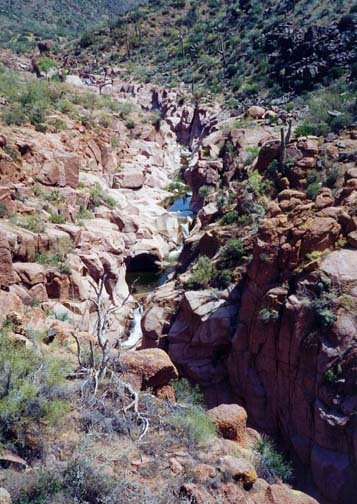
Out in the Arizona wildlands, beyond the end of the Apache Trail, on the far northeastern side of Roosevelt Lake, is the remote Salome Wilderness. It is rugged mountainous country, a land of rock and cactus where the summer temperatures soar into triple digits and all man's ingenuity is needed just to survive. Water is king here and the winter storms create ribbons of life that manage to survive through the baking heat of the summer sun. The rain funnels down into Salome Creek, a river that drains a large area in the Sierra Ancha mountains and flows southwest into Roosevelt Lake. On its way there, the creek has had to cut its way round the base of the great rock monolith known as Dutchwomen Butte and, in doing so, has carved deeply into the pink and white granite to create a fantastic, mile-long ravine known as the Salome Jug. This narrow, vertical-walled jewel of a canyon makes for one of the most marvellous canyoneering experiences anywhere in the world. The descent requires almost continuous wading and swimming through ravine-filling pools, interrupted by numerous waterfalls and cascades. Most are readily downclimbed though one spectacular 30ft drop near the end requires either a rappel or a scary jump into a deep pool.
This adventure is not possible in the winter because of the high water flow rate. On the other hand the river tends to dry up as the summer progresses and the pools accummulate a surface scum of green slime. Consequently the best time is either May or June when the flow is moderate, the water is clear and not too cold, and the air is warm enough to allow one to dry out and warm up in the sun.
Trailhead
From the intersection of State Highways 87 and 188 about 60mi northeast of Phoenix, Arizona, drive southeast on SR 188 for 19.4mi through the hamlet of Punkin Center to mile post 255. Turn left following the sign for the A+ Cross Road and note the odometer reading. The dirt road drops down into the wide river valley and, after about a mile, crosses the stream at a broad ford where the water is usually only about six inches deep. On the other side continue on the good dirt road following the posted sign for Salome Creek. At a fork where dirt roads go left continue straight as the road becomes asphalt. This asphalt road ends at a boatramp and campground but, about 1.8mi before that (and 2.3mi from SR188), you must turn left onto a dirt road signposted A+ Cross Road. This turn is easily missed but if you arrive at the boatramp just backtrack 1.8mi. The dirt road winds in and out of various drainages as it climbs episodically along the southern slopes of Victoria Peak. Soon the imposing mass of Dutchwoman Butte comes into view ahead to the east. As you come to the last ridge between you and the Butte, you will easily find the A+ Cross Trailhead, 10.1mi from SR188 at 33o46.24'N 111o8.17'W. The parking area is on the left side of the road. Except in winter, the ford and the dirt road are passable in a 2WD vehicle but a high ground clearance, 4WD vehicle is preferable.
Hike
The trail which heads east from the A+ Cross Road was previously an old jeep road. From the trailhead (33o46.24'N 111o8.17'W and elevation 3200ft), it begins by winding in and out of three large gullies. With each successive headland you get closer to the shadow of Dutchwomen Butte. Though sparsely vegetated, the land is populated with cacti including giant saguaro, prickly pear, ocotillo and many smaller varieties. In May or June, many of them may be in bloom, an added delight on the morning start. As you contour into and out of the gullies, the trail begins a gradual descent until, just after the fourth headland and about 1.8mi from the trailhead, it starts a steeper switchbacking descent down a shallow draw. Below you here you can see the edges of the ravine known as the Salome Jug. As you reach the flatter ground above the rim of the ravine, the old jeep trail turns north and begins travelling upstream, paralleling the gorge. Soon it passes through a barbed wire fence and gate (33o46.23'N 111o7.22'W) and just beyond this you will encounter a flat rock shelf to the right of the path which has marvellous views of the creek. Looking upstream you see a series of waterfalls and pools as the stream begins its drop into the ravine. You can also look straight down into a ravine-filling pool within the Jug. You should reach this point (elevation 2840ft) about 2.4mi and just under 1hr after starting out. From here continue up the trail for about another 40yds to where there is a flat area to the right of the road that looks as though it has been used for a campsite. From here take a short spur track toward the ravine at the end of which (33o46.30'N 111o7.18'W) you should be able to find a way to climb down to the stream at a point where there is a series of pools and cascades.
 | 
| |
|---|---|---|
| Salome Creek just upstream of the Jug | In the upper Jug |
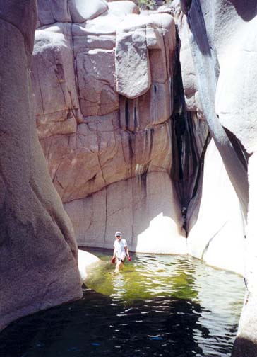
Immediately you must take to the water, swimming and wading, in order to progress downstream. The ravine walls rapidly grow in height and the gorge narrows to about 20ft. The first couple of cascades are awkward and slippery to descend but soon you get used to swimming, wading and downclimbing. The polished granite walls rise vertically on all sides and have been sculpted into spectacular shapes by eons of rushing water. Some distance into the gorge, there is an awkward 10ft drop where the stream splits on two sides of a huge, canyon blocking boulder. We rigged a small rappel here rather than attempting the slippery downclimb. A succession of pools and swims follows. We stopped for lunch on a warm boulder beside the only tree we encountered in the gorge - though there are many similar boulders on which to rest and warm up.
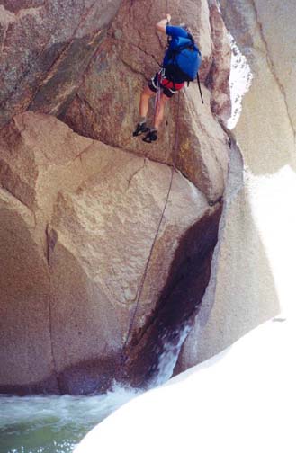
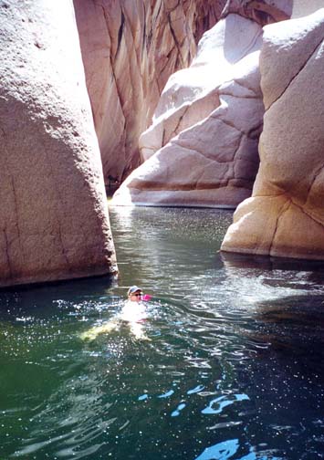
Nearing the end, where the walls of the gorge are reaching their maximum height, you come to an alarming obstacle where the stream drops through a narrow slot to a large pool that stretches away down the gorge. Because there are few features of recognizable dimension, it is hard to judge the magnitude of this drop. In fact, it is not as big as it seems from the top. A shelf about 6ft up the rockface on the right allows you to traverse over to a point where there are anchor bolts in the rock high above the pool in the cavern below. This traverse is nervy since the rock face is sloped and can even be a little slippery. However, there is another bolt fixed in the rock where the traverse starts and, when we came this way, a 20ft length of webbing was stretched across between this bolt and the rappel anchor. This webbing provided an essential handrail for the traverse over to the rappel anchor. If the webbing is not there, you should set up a belay using the anchor. The drop from the rappel anchor to the bottom of the waterfall is about 30ft; it allows a vertical descent with some free rappel and an awkward swimming disconnect in the churn at the base of the falls. From there you swim just a few yards to the broad rock shelf in a recess on the far side of the ravine where you can rest and monitor the descent of the others. As an alternate to the rappel, you may decide to use a rope to descend 5ft from the rappel anchor point to a small platform where you can jump 25ft into the deep pool below. Though I do not recommend this, it is clear that many do it.
 | 
| |
|---|---|---|
| Bottom of the rappel | Big pool beyond the rappel |
After resting on the shelf in the recess, the next hurdle is a swim downstream of about 50yds, negotiating a deep pool with vertical walls on all sides. This leads to several more long, deep swims interspersed with bouldery downclimbs. In the last of these you swim out of the gorge between vertical walls. The Jug ends abruptly, the stream emerging into a broad valley on its way down to Roosevelt Dam several miles away. You should reach the end of the Jug (33o46.02'N 111o7.26'W and elevation 2660ft) about 3hr 45min after the morning start.
As you emerge from the Jug, turn right immediately, leave the stream
and follow the use-trail up
the steep slope in a shallow recess. The trail transitions onto a bluff
and leads directly back
to the old jeep trail at the bottom of the previously mentioned
switchbacks (33o46.13'N 111o7.33'W).
From here it is
a relatively easy return hike of 2.2mi back to the trailhead
(33o46.24'N 111o8.17'W),
though this may be the hardest part of the hike due to the hot
afternoon sun. The complete adventure should take less than 5hr
and cover about 5.1mi.
Christopher E. Brennen