ADVENTURE HIKES AND CANYONEERING
IN THE SOUTHWEST
© Christopher Earls Brennen

|
|---|

|
Hike K1. Rose Valley Falls
- Hiking time: 6 hours
- Hiking distance: 4.2 miles
- Elevation gain: 1620 feet
- USGS Topo Maps: Lion Canyon
- Difficulties: 2 big rappels
- Special equipment: 250ft rope, 250ft recovery cord, rappelling equipment, 30ft webbing, 2 rappel rings
-
ACA Rating: 3B/C III

Characteristics
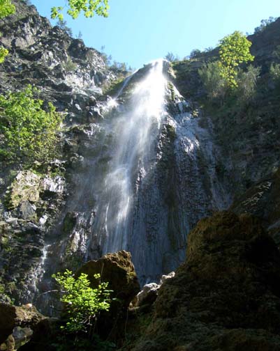
The tallest waterfall in Los Padres National Forest is said to be the upper Rose Valley Falls in western Ventura County, a spectacular 250ft vertical cascade that careens down a limestone encrusted face. In winter when flowing fully this would represent an almost impossible rapelling challenge. But, in late spring, when the flow eases to a spray it makes for an awesome and spectacular descent. In the summer the falls dry up almost completely and the rappel is then less challenging and less fun.
The hike described here starts at the Rose Valley campground from which the upper Rose Valley Falls are readily visible. Bring a pair of binoculars so that you can evaluate the falls and the flowrate before starting out. If the flow is judged too great you might consider modifying your plan and taking the short, 20min and 0.5mi trail hike up to the bottom of the falls. The hike described proceeds up a fire road to the ridge above the falls and then descends a rough gully to the top of the upper Rose Valley Falls. Having descended this it is a short hike to the lower Rose Valley Falls, a 100ft rappel to the end the day.
Trailhead
Drive north of Ojai, California, along Highway 33 through Wheeler Gorge to a point 14mi north of Ojai where the Rose Valley Road forks off to the east (right). Continue for 3.1mi along Rose Valley Road where you will turn right following the signs for 0.6mi to the Rose Valley Campground. Park at the far end of the campround loop at 34o31.91'N 119o10.99'W and an elevation of 3420ft.
Hike
From the parking area at the top of the Rose Valley Campground loop at 34o31.91'N 119o10.99'W and an elevation of 3420ft, cross the stream and head west along the fireroad that soon starts to climb steeply. That vigorous rate of ascent continues all the way to the ridgetop at 34o31.16'N 119o11.84'W and an elevation of 5040ft. There, 2.1mi and 1hr 40min from the start, you will come to the junction with the Chief Peak fire road that runs along the ridgetop. Your ascent is thankfully complete at this point. Turning left you proceed eastwards along the Chief Peak Road for another, relatively level mile to the drop-in point where you leave the road and start down the gully toward the falls.
You should reach the drop-in point at 34o31.07'N 119o10.88'W and an elevation of 4990ft about 2 hrs from the start having covered about 3.1mi. As you are hiking along the road look for a small pond to the left of the road and drop down into the wash on the left just beyond the pond. At the start the hike along the wash requires some modest bushwhacking but the wash soon steepens and you enter a wooded area where there is little brush and the descent down the boulder strewn wash is quite easy. About the 4400ft level you may begin to see a small trickle of water and there are several moss-covered waterfalls that make for a good lunch stop.
 | 
| |
|---|---|---|
| Upper Rose Valley Falls | Lower Rose Valley Falls |
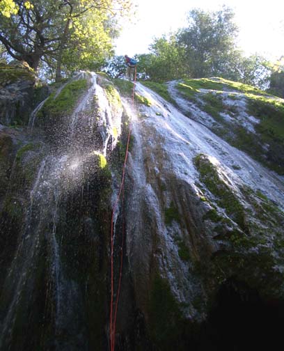
At 4290ft (about 3hrs from the start) a large tributary enters on the right and the trickle becomes a small stream. Downstream of this confluence there are a number of small downclimbs and several drops that can be bypassed on the left or right. Then, quite abruptly, you arrive at the awesome drop-off at the top of the upper Rose Valley Falls. You should reach this point at 34o31.57'N 119o10.78'W and an elevation of 3950ft about 3.5hrs from the morning start having covered 3.7mi. It is difficult to get a good view of the base of the falls in order to judge your descent route but the easiest way lies to the left. We anchored from a stout bush about 20ft up on the left side a little ways back from the lip and extended the webbing down to a point just around the shoulder to the left of the lip allowing for an easy entry to the rappel. With a 250ft rope and a 250ft recovery cord you can rappel all the way to the bottom of the falls. You will get wet from the abundant spray but this anchor avoided the main stream of of the waterfall.
[For experienced canyoneers only: It is possible to descend with a 200ft rope and a 200ft recovery cord but only along the route described. There a 200ft rope will allow you to just reach a narrow ledge to the left of the falls and you can traverse along this wet and slippery shelf to a scree slope on the left that allows an easy downclimb to the base of the falls. Stay on rappel while traversing the ledge. Make sure your ropes are 200ft; even if they are 10ft short you will be in trouble.]
Pause at the bottom of these magnificient falls to enjoy their splendor. Looking up you will note an overhanging limestone formation at the top that you just avoided by taking the suggested route. That formation creates the great broad spray that characterizes these falls in modest flow. You should reach the bottom of the upper Rose Valley Falls at an elevation of 3690ft about 5hrs from the morning start.
It is just a short steep clamber down the stream from the base of the upper
falls to the top of the Lower Rose Valley Falls.
This lovely 100ft waterfall casacdes down a limestone-fluted and moss-covered
face. There is a dry route from a tree anchor on the left side of the lip.
Alternatively you may choose a wet route down the middle of the falls that
uses as anchor the large tree a short way back from the lip.
You should reach the bottom of the lower Rose Valley Falls at an elevation
of 3530ft about 5.5hrs from the morning start. From there
a well-maintained trail leads back to the Rose Valley Campground
about 0.5mi away.
You should reach the Rose Valley Campground
(34o31.91'N 119o10.99'W and an elevation
of 3420ft) about 6hrs and 4.2mi after the morning
start.
Christopher E. Brennen