ADVENTURE HIKES AND CANYONEERING
IN THE SOUTHWEST
© Christopher Earls Brennen

|
|---|

|
Hike G14. Rainbow Canyon, Death Valley
- Hiking time: 6.5 hours
- Estimated hiking distance: 7.3 miles
- Elevation gain: 860 feet
- Topo Maps: Darwin, Panamint Springs
- Difficulties: Four rappels up to 170ft
- Special equipment: 200ft rope, 200ft recovery cord, 40ft webbing, three rappel rings, rappelling equipment, helmets
-
ACA Rating: 3A III

Characteristics
Death Valley National Park contains some of the most rugged and fantastic landscape in the world and provides some marvellous adventures and canyoneering experiences. Though the heat in the summer is intolerable, the Park has the advantage that the mild winter weather allows outdoor activity when much of the rest of the southwest is too cold and wintery. This collection contains a number of adventures in Death Valley National Park. Though the hike to the summit of Telescope Peak is a summer outing, the other, canyoneering adventures included in this collection are best suited for the late fall, winter and early spring.
In particular this collection contains two canyoneering adventures on the west side of the Park near Panamint Springs and close to Highway 190. Indeed, Rainbow Canyon, the subject of this descent, is visible to the north of Highway 190 for several miles west of Panamint Springs. It is a rugged 1000ft deep gorge with headwalls that require three long and dramatic rappels. However, after those initial technical challenges it is mostly an easy hike down the gravel wash in the bottom of the canyon. Along the way you are entertained by the multicolored walls that give this canyon its name. Toward the end we describe a short cut involving a short climb out of Rainbow Canyon and back to your return vehicle on Highway 190.
Trailhead
This hike requires a car shuttle along Highway 190. To deposit the return vehicle drive 1.8mi west from Panamint Springs up Highway 190 to a saddle at 36o20.77'N 117o29.43'W and an elevation of 2410ft. Here there is a good parking area on the right side of the road and overlooking the wash to the north.
Then, in the other vehicle(s) continue west along Highway 190 as it winds its way up to the Darwin Plateau. On the way you will pass a dramatic overlook of Rainbow Canyon where you can look straight down over 1000ft into the canyon that you will be hiking later in the day. A short but rough dirt road leads down from this point to the Father Crowley overlook where the view is even more spectacular. Continuing west on Highway 190 you will come to a section around an elevation of 4500ft where Rainbow, the canyon on your right clearly runs out. Park here by the side of the road at 36o21.61'N 117o34.78'W and an elevation of 4600ft. This point is 8.1mi from the return vehicle and 9.9mi from Panamint Springs. From the parking spot you should be able to discern an uninterrupted and gradual slope down to the head of Rainbow Canyon.
Hike
From the starting point at 36o21.61'N 117o34.78'W and an elevation of 4600ft, hike northeast down over flat ground toward the head of Rainbow Canyon which should be visible in the distance. After 15min and 0.6mi you will come to the shallow wash at 36o21.98'N 117o34.27'W and an elevation of 4330ft, known here as the Santa Rosa Wash. If you encounter a cliff then contour left to find the wash.
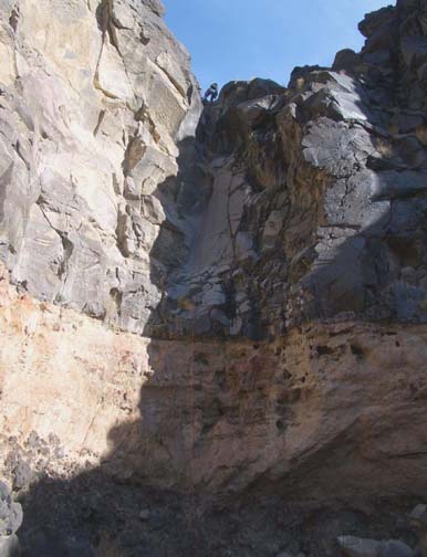
It is just a short stroll down the wash to the first, dramatic drop-off and rappel. A horizontal layer of solid black rock rings the top of a great amphitheater that you don't really see until you are right upon it. Below the solid black layer are looser layers of yellow, red and brown rock, much more friable so that once the water managed to erode through the black it was able to dig much deeper quite quickly. You should encounter this rim about 20min from the start at 4260ft; the rappel is a 100ft vertical drop from one of several possible rock horns and places you in a broad, boulder-strewn basin. If you wish this first rappel can be bypassed by descending a rough scree slope further around the rim on the left.
 | 
| |
|---|---|---|
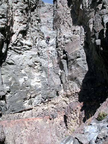
| First 100ft rappel in Rainbow Canyon | Second 170ft rappel (Photo by Michelle Nilles) |
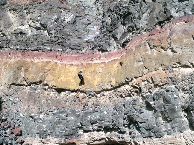
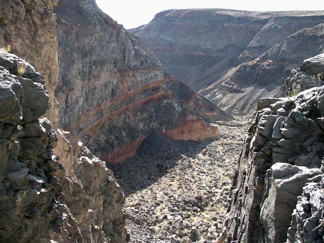
It is just a short walk down canyon to an elevation of 4150ft and the spectacular second and third falls, two rappels with vertical drops of 170ft and 90ft respectively. These take you down into an even larger amphitheater, now a massive 1000ft canyon whose walls of striped black, red and yellow rock led to the name Rainbow Canyon. The anchors for both rappels are large midstream rockpiles. The 170ft rappel drops you into a large hole at the bottom and this requires an 8ft climb to exit the hole. Then the lip of the 90ft drop is just a few yards away. Like the first rappel it consists of a strata of dense black rock overlaying a layer of crumbly red-yellow rock. This deposits you in a huge, fairly flat boulder field. You should reach this point (elevation 3900ft) about 2hrs from the start having travelled about 1mi.
Initially travel down through the boulder field is slow going though the streambed gradually accumulates gravel and, as it does, this is the easiest route to follow. You feel insignificant and very alone in this huge, multicolored gorge though after about an hour you might spot the tiny silhouettes of tourists high on the southern rim at the Father Crowley Viewpoint. At about 3400ft, 1hr 10min from the rappels and 3hrs from the start, you will arrive at the top of the last rappel, a small 20ft drop where there are numerous big boulders for an anchor. After another hour or so the canyon begins to open up and the southern wall decreases in steepness and height. From this point you could continue all the way to the end of Rainbow Canyon, turn right at the exit and hike south across the desert to Panamint Springs. However, that is a long and less interesting hike and we describe here a short cut that substantially decreases the length and duration of this part of the hike and takes you back to where you left the return vehicle.
 | 
| |
|---|---|---|
| Third 90ft rappel | Rainbow Canyon | |
(Photos by Michelle Nilles) | ||
About 4.1mi from the bottom of the big rappels, 5.1mi and 5hrs from the start at 36o21.88'N 117o30.22'W and an elevation of 2200ft you should be able to discern a fairly easy climb up the right side of the canyon to a flat plateau on top. The actual climb is easier than it looks because the rocks make good footholds and are mostly very secure. It is a 420ft ascent up to the surprisingly flat plateau. If you are fortunate you may encounter a small and interesting dry lake on top.
Highway 190 should now be visible to the south and so you
hike in that direction and descend into the next wash that runs below and
just to the north of the highway. Cross the wash and choose a suitable route
to ascend to the highway, another climb of about 440ft. The saddle
where you left the return vehicle will have been visible for some time
and so the last leg is a brief descent along the road to the saddle
at
36o20.77'N 117o29.43'W and an elevation of
2410ft. The complete hike should take about 6.5hrs during which
you cover about 7.3mi.
Last updated 11/20/03.
Christopher E. Brennen