ADVENTURE HIKES AND CANYONEERING
IN THE SOUTHWEST
© Christopher Earls Brennen

|
|---|

|
Hike J3. North Fork of Kings River
- Hiking time: 11 hours
- Estimated hiking distance: 4 miles
- Elevation gain: none
- Topo Map: Patterson Mountain
- Difficulties: About 7 rappels over 30ft, most with swimming disconnects, many smaller downclimbs/jumps/rappels and much bouldering. Many long swims, several over 300yds long.
- Special equipment: Full wetsuit, helmet and rappel gear, drybag, two 50m ropes, 50m pull cord, some webbing, several rap rings.
-
ACA Rating: 4CR IV

Characteristics
The Sierra Nevada mountains are riddled with wilderness canyons that promise extraordinary adventure and outdoor challenge. Here we explore just one such canyon, that of the North Fork of the Kings River. Over a stretch of about ten miles the North Fork winds through a deep canyon, one moment crashing down a steep and narrow gorge, the next moment flowing serenely through long deep pools. In the summer when the volume flow is low (and controlled by a series of small dams) the ten miles are a water wonderland with endless challenges for the experienced canyoneer. Here we describe a hike through the last three miles of the canyon; there are also several other stretches upstream that would be alternate (and somewhat shorter) adventures. All of the hikes are best undertaken during the heat of summer.
It should be emphasized that this adventure is only for the experienced and well-prepared canyoneer. Because of the length of time spent in the water and in the shade, a full wetsuit is recommended even in 100 degree summer heat. Moreover, the rock is Sierra Nevada granite polished by ice, water and the sun; it can be remarkably slippery and therefore shoes with sticky rubber soles are a must. Even well-equipped, this is a long, exhausting and physically challenging adventure. In many places one is faced with the choice between a slow rappel and a quick but potentially dangerous jump. The pools are generally deep, but the danger involved with jumping is still present. The timing described below assumes only small jumps where the pool depth is clearly adequate.
Trailhead
The North Fork of the Kings River is deep in the western foothills of the Sierra Nevada mountains of California. The last part of the approach is a long, narrow and twisting road that takes several hours.
From the north or west, take the Jensen Avenue exit from US99 and drive east on Jensen for 12mi to Academy where you turn left. From the south take the exit onto Sierra Drive in Kingsburg, turn right, cross the railroad tracks and then turn left onto Academy. Drive north for about 17mi to the town of Sanger where both approaches merge. Continue north on Academy for 2mi and turn right onto Belmont. After a few miles Belmont becomes Trimmer Springs Road and you will stay on this road for many miles as it leaves the valley and climbs into the foothills. From the Belmont/Academy intersection, you will pass the hamlet of Piedra after 13mi (one of the last chances to fill up on gas and groceries). The road then begins a long and tortuous route along the north shore of Pine Flat Reservoir. The last restaurant is at the launch ramp in Lakeview, some 20mi from the Belmont/Academy intersection; some 5.6mi further you pass through the abandoned facilities in Trimmer. Another 16.8mi (total of 42.4 from Academy/Belmont) will bring you to the Kirch Flat campground, a pleasant shady location beside the Kings River. It is a good place to camp for the night.
Five miles beyond Kirch Flat campground (elevation 1130ft) you will come to Balch Camp (elevation 1270ft), the crossroads for this hike. At the first junction in Balch Camp (36o54.17'N 119o7.29'W), fork right and follow the signs for the Balch Powerhouse. This is a private road but one which is open to the public. Two miles from Balch Camp the road ends at the Balch Powerhouse where a locked gate and a fence topped with barbed wire prevent access to the powerhouse compound. Park the recovery vehicle in the large dirt area (36o54.57'N 119o5.39'W) about 50yds downcanyon from the gate.
Then drive back down to Balch Camp, turn right and cross the bridge over the North Fork of the Kings River. Fork right at the next junction and begin the switchbacking climb up the narrow road toward the trailhead (Wishon direction). Very narrow and twisting, this road eventually contours around into the North Fork drainage. About 9mi from Balch Camp look for a dirt parking area on the right (36o54.59'N 119o3.21'W and elevation 3920ft) and the partially hidden dirt road that leads down to the river. Park in the dirt parking area.
Hike
The adventure begins as you pass by the gate and hike about 0.8mi down the steep dirt road to the river at 36o54.23'N 119o3.08'W and elevation 3400ft. The view of the river from the end of the dirt road is a foretaste of the spectacular natural water world that lies downstream. You might wish to judge the stream flow at this point - if you feel that swimming the first few pools or being caught in the flow over the first waterfall would be a problem, you would be well advised to turn back for the hike ahead is a challenge even for expert canyoneers.
It is wise to don your wetsuit before entering the river for, even on the hottest day, you will need the insulation and flotation it provides almost immediately. Boots with sticky rubber soles are also essential for the polished granite of the Sierra Nevada can be remarkably slippery and you will find the sticky rubber traction very valuable in many places.
 | 
| |
|---|---|---|
| View downstream from start | Second of the set of three waterfalls |
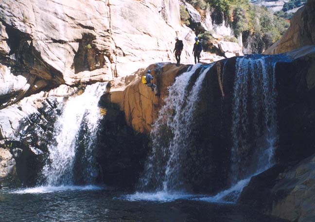
To begin the river descent, hike along the ledge on the right past the first waterfall to find the anchor for the drop into the pool beyond. A single bolt is backed up by a wrap around a stout bush. Rappel down about 30ft to a deep wade and swim. A short distance downstream you will arrive at a series of three 25ft waterfalls. You may choose to jump the first two or rappel them together from a bush anchor in a pothole above the first drop. The third drop may be downclimbed on a ledge to the left. You should reach here (elevation 3220ft) about 1hr 20min from the start.
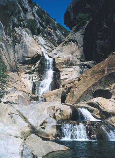
A little downstream, after several short swims, you will arrive at the top of a large 70ft waterfall. Climb up a steep gully on the right and contour along the top of a steep slickrock slope, past reassuring trees and bushes, before descending again to the water's edge. Beyond this the canyon narrows and there are slides to slide and pools to swim. Eventually, 2hr 40min from the start at 3040ft, the canyon narrows further and you must swim through a defile that ends at a dangerous lip. Stop before you reach the lip when you see a bolted anchor a short distance above the water level on the left. Because of the slippery rock, it would be wise to belay each canyoneer as they climb up to the anchor station. Once there you are treated to a spectacular vista of a tremendous drop downstream. The first step is a 50ft rappel into a huge hanging pool with a swim across to a second, similar bolt station. Again the short climb to the bolts is slippery so special care is needed. The drop on the other side is quite spectacular and looks greater than its 150ft. There are two ways to descend this drop. The direct route straight down from the top anchor will take you straight into the teeth of the waterfall - an exhilerating experience but a difficult one. However, unseen from the top, there is a second bolt station about 20ft below you on a ledge off to the left. If you rerig at this second bolt station you can avoid the full force of the falling water. The pool at the bottom is large and very deep. It is a majestic waterfall whose beauty adds to the sense of accomplishment. You should climb out of the pool on the right. Two small drops follow, one 15ft rappel or jump and one downclimb. Here, there is a broad sunny area that makes a good place for a break. You should reach this point (elevation 2840ft) about 4.5hrs from the start.
 | 
| |
|---|---|---|
| Looking up at big 150ft waterfall | The 80ft gorge descent |
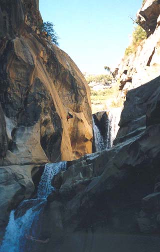
The river now enters a narrow slot with a low ledge up on the right. Follow the ledge along to a short jump down into a pool below the falls in the slot. The canyon then turns sharp left and you need to be sure to follow another broad ledge on the right that takes you out to a bolted belay station (with webbing around a large boulder), about 100ft above a pool in the narrow gorge. Here you will also find a register in a metal ammunition box. The 100ft drop is mostly a free rappel. Below it you climb onto a ledge on the canyon left. This leads to a small and tricky 20ft drop that is best descended as a continuation of the 100ft drop. Here you can find yourself in a fierce spout so jumping may be a better option. This brings you to the end of the narrows and the canyon broadens substantially. Just after the 20ft drop you swim a large pool. Head for the left side of the next lip in order to avoid having to cross the stream at the top of a large waterfall. Climbing out of the pool you get a good view downstream of a series of large waterfalls. Bypass these by taking the brush covered ledges on the left around to a gully that can be downclimbed through the brush to the water's edge.
Here at 2800ft and 6hrs from the start, you begin transit through a more benign section of the canyon though with lots of downclimbs or small jumps and many long swims, some over 300yds in length. Eventually at 2360ft and 8hrs from the start, the canyon drops into a short section of difficult narrows. It is important to recognize this location for you must climb to a ledge on the left to access a webbing anchor around a large boulder. This rappel descends about 80ft to the water's edge from where you continue with the swimming, bouldering and jumping. This bouldering is slow going and very tiring. Eventually you come to a long, open slickrock descent on both sides of the river. Take the left side and descend to a very broad flat lip about 50yds wide. You should reach this lip about 10hrs from the start.
At this broad lip, the river plunges an awesome 250ft into a deep canyon whose bottom is hard to view. But you should be able to find the use-trail through the bushes on the left that follows a sloping ramp all the way down to the river below these awesome falls. The last 30ft of this descent is equipped with fixed ropes to use as a handline. More slow bouldering follows until you finally see the Balch Powerhouse ahead of you. A final obstacle awaits: just before you reach the powerhouse there is a 20ft waterfall that neccesitates a last rappel from a large metal anchor to the left of the falls. This descends to the rocks at the water's edge. From there you contour around to the left and clamber up the rocks to a dirt road that leads toward the powerhouse.
The grounds of the powerhouse (elevation 1740ft) are closed to the public and so you must find a way around them either by clambering up the hillside on the left outside the fence (the descent down
to the road downstream of the powerhouse may be the hardest part of this manoever) or by swimming past the powerhouse. PG&E have told the Forest Service that they will improve the route around the powerhouse but whether either of them will follow through on their obligation and desist from unnecessarily blocking passage down the canyon remains to be seen. Either way the parking area with your recovery vehicle
(36o54.57'N 119o5.39'W) is just downstream of the powerhouse.
The 3mi through the gorge from the drop-in to the powerhouse
will take about 11hrs.
Last updated 27/7/04.
Christopher E. Brennen