ADVENTURE HIKES AND CANYONEERING
IN THE SOUTHWEST
© Christopher Earls Brennen

|
|---|

|
Hike C2. Neon Canyon
- Hiking time: 8.5 hours
- Estimated hiking distance: 10.8 miles
- Elevation gain: 1440 feet
- USGS Topo Map: Egypt (UT)
- Difficulties: Five rappels up to 80ft, a potential keeper pothole, possible slot swimming
- Special equipment: Rappeling equipment, 100ft rope, 100ft pull cord, 40ft webbing, 5 rappel rings, harnesses, helmets, wetsuits and dry bags
-
ACA Rating: 3B III

Characteristics
East and north of Lake Powell in the southeast corner of Utah is some of the most remote terrain in the United States. Now the site of the Grand Staircase/Escalante National Monument and the Glen Canyon National Recreation Area this is a parched land of mesas and escarpments, flat at the higher elevations but worn away at the lower into steep canyons and red and white slickrock. Southeast of the small town of Escalante in Utah lies the lower canyon of the Escalante River as it winds its way down toward its junction with Lake Powell and the Colorado River. Numerous tributaries feed their storm water into the Escalante and many of these have carved fantastic sculpted canyons through the red Navajo sandstone. The Egypt Slots and Neon Canyon featured in this collection represent just three of hundreds of examples of these slot canyons.
Neon Canyon is a magnificent little canyon that fully rewards the effort it takes to reach it. The short version of the canyon descent described here has a marvellous short and wet slot, followed by an amazing (but potentially troubling) pothole and then the magnificent Golden Cathedral, a natural light show that alone is worth the trip. But all of this takes some getting there, a drive to one of the really remote areas in the contiguous United States, a rough dirt road to a trailhead and then a substantial hike down to the Escalante River.
There are several ways to plan this adventure. One is to start early from the trailhead and to return there at the end of the day. If Neon Canyon is your sole objective in the area then this is probably the best plan and this is what is described herein. However, there are other adventures in the same area (for example, Choprock Slot) and if you plan to do these as well then it makes sense to backpack down to the Escalante from the trailhead and camp, for example at the site where Fence Canyon joins the Escalante.
The best time of the year for hiking in this area is either the spring or fall when the weather is warm but not too hot.
Trailhead
To reach the trailhead for Neon Canyon starting in the town of Escalante, Utah, you should drive east along the paved Highway 12 for about 5mi to the well-marked turn-off to Hole in the Rock Road. Turn right onto this high-quality dirt road and drive 16.7mi southeast over a gently rolling mesa to where there is a turn-off on the left to the Egypt Trailhead. Turn left and drive down this less developed dirt road. You might note a nice campsite on the left just 0.5mi down this spur road which is useful after the long drive to get here.
The Egypt road gradually worsens as you proceed and is recommended only for high clearance vehicles though a regular car can make it with a little careful obstacle avoidance. It is 9mi to a fork in the dirt road. Turn right here and drive just 0.5mi to the Egypt Trailhead at the end of the road. Park here at 37o35.59'N 111o13.06'W and an elevation of 5620ft and complete a free trail registration.
Hike
From the Egypt trailhead at 37o35.59'N 111o13.06'W and an elevation of 5620ft follow the trail as it drops over the rim and soon begins a steep descent on the bare slickrock. The pack animals who frequent this trail have left their distinctive white shoe marks on the slickrock and, as a result, made the trail easy to follow. After almost 500ft of descent the trail reaches the bottom of the escarpment and begins a gentle, sandy traverse across a wooded bench above the north side of Fence Canyon. Eventually the trail comes to the heights at the apex of two forks of Fence and switchbacks down into the southern fork. Just below this, Fence Canyon meets the Escalante at 37o36.75'N 111o10.72'W and an elevation of 4540ft. It should take about 1.5hrs (2hrs with an overnight pack) to reach this point, 3.3mi from the start. There is a popular camping spot here because springs in Fence Canyon produce a reliable rivulet of clear, silt-free water.
|
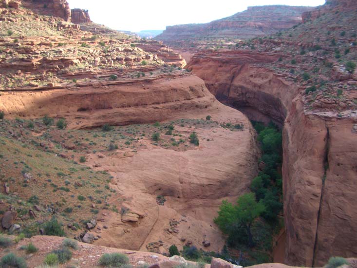
|---|
| Neon Canyon from its entrance ridgetop |
From Fence Canyon, you have to briefly wade in the Escalante in order to proceed downstream, and then cross to the left bank after about 0.3mi. You should then traverse across the Escalante floodplain to the left wall and follow it downstream for another 0.6mi or so to the entrance to Neon Canyon. A little before reaching Neon you will see extensive array of petroglyphs (mostly old but some modern) on the cliff face above you. You should reach the entrance to Neon Canyon at 37o36.40'N 111o10.03'W and an elevation of 4540ft after a 40min and 0.9mi hike from Fence Canyon (2hr 15min and 4.2mi from the trailhead). At the entrance note the irridescent blue sheen to the canyon wall on the right that may have given this canyon its name.
About 100yds into the canyon note the part scree/part slickrock slope ahead of you on the left side of the canyon and the trail that climbs this slope. Follow this as it veers left and climbs about 140ft to reach the ridgetop between Neon and the Escalante with marvellous views of both. The ridgetop is at 37o36.47'N 111o10.07'W and an elevation of 4680ft. Having enjoyed this rest stop, you should then follow the usetrail that proceeds along the bench at the same elevation as the ridgetop, contouring up the left side of Neon. The trail continues on that broad bench, contouring into and out of several washes with spectacular overlooks of the dramatic Neon canyon below you on your right. It is clear that below these upper level benches the raw slickrock falls off precipitously into the canyon bottom. The normal drop in from the trail is 1mi from the ridgetop at 37o37.11'N 111o9.78'W and an elevation of about 4900ft, 2.2mi from Fence Canyon or 5.5mi from the trailhead. Here a GPS is useful to locate the drop-in route though it is the first place where a downclimb into the canyon bottom looks remotely possible from above. There are a few green trees in the canyon bottom nearby. The drop-in route is a broad broken gully in the corner where the canyon turns right (looking upstream). Climb down ledges in the gully to within about 25ft of the canyon floor where there is a final, vertical drop down to the canyon floor. A webbing anchor around a boulder atop this final drop allows completion of the descent. Here you are at 37o37.025'N 111o9.690'W and an elevation of 4700ft. You should reach this point about 2.5hrs and 2.2mi from Fence Canyon or 4hrs and 5.5mi from the trailhead.
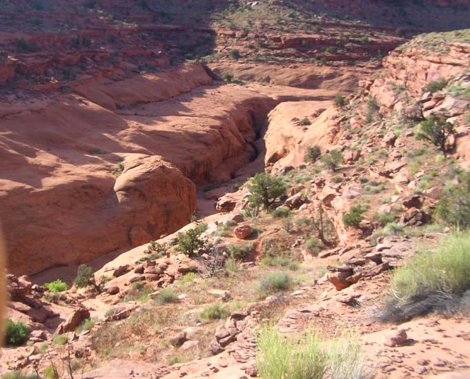 | 
| |
|---|---|---|
| Drop-in point from trail overhead | Keeper pothole from exit |
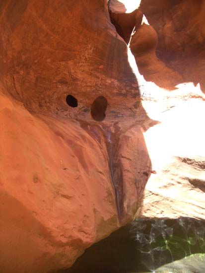
Turning downstream within about 100yds you will arrive at the top of a slot cut in the canyon bottom (it is visible from the trail overhead). Here you should don your wetsuit and prepare for swimming in the cold water of the slot. The descent into the slot requires a 25ft rappel from a chockstone webbing wrap down into a pool that maybe be 0-5ft deep. From there it is ten yards to an interesting blind corner with a 4ft climb (or swim out). Proceeding under a wedged boulder, this is followed by several more pools in convoluted slot that may be swimmers. These lead to a 12ft drop down under a wedged boulder that has an anchor wrap for those that might want a rappel or handline down. More pools and slots follow before you arrive at the convoluted start for the famous Neon keeper pothole. This begins at the top with an amazing maze of small multiple holes and potholes which you climb through to reach a ledge about 25ft above the water level above the keeper pothole which is about 20ft across. In times past this pothole has been completely filled with sand so that the drop is a simple rappel from an anchor threaded through the holes at the top, descending to a sandy bottom that opens up into a wide canyon area. However at other times such as when we went through there is a deep pothole that gets dangerously wider with depth so that it is overhung all the way around. This means the lip is substantially overhung and difficult to climb out of. Moreover there is a steep gravel bank above the lip so that there is nowhere for a toss-bag purchase. This pothole can therefore present a very serious obstacle. When we descended the water level in the bottom was only about 3ft deep and the exit lip was about head height so that a partner assist allowed climb out. However in the recent past, the sand level has also been substantially deeper, creating even more overhang and making the exit extraordinarily difficult. Go with a party of at least three and do not pull the descent rope until one climber has managed to climb out of the pothole.
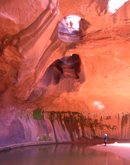 | 
| |
|---|---|---|
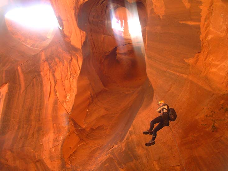
| The Golden Cathedral | Author descends the Golden Cathedral (Photo by Sonny Lawrence) |
From the pothole it is just 50yds through a broad canyon to the top of the Golden Cathedral rappel. This begins as a narrowing that leads to a small slot with a long webbing anchor around a boulder that snakes down that slot that leads to a hole overlooking the Golden Cathedral. You rappel down through that hole and descend 80ft (about 40ft of free rappel) through a magnificent, multicoloured cavern with two great holes in the roof, one you descend through and another further out on the overhanging roof. The pool beneath could be a swim but is often chest deep. If the sunlight is right ripples on the surface reflect to create glitter off the golden roof, a fantastic natural light show.
You should reach the bottom of the Golden Cathedral (elevation about 4500ft) roughly 3hrs 45min after leaving Fence Canyon or 5hrs 15min from the trailhead. Here you can shed your wetsuit and prepare for an easy exit hike. It is a beautiful 25min hike down the rest of Neon Canyon to the Escalante where you then retrace your steps to Fence Canyon. The hike back up from Fence Canyon to the trailhead is a tough end to this adventure and should take about 2hrs (closer to three with an overnight pack).
It should take a total of 8hrs 30min for this adventure (5hrs from Fence Canyon camp and back there) during which you travel 10.8mi (4.2mi from Fence Canyon and back there).
Many thanks to Steve Ramras and his family for their guidance in this
Escalante region.
Last updated 5/18/07.
Christopher E. Brennen