ADVENTURE HIKES AND CANYONEERING
IN THE SOUTHWEST
© Christopher Earls Brennen

|
|---|

|
Hike D4. Zion's Mystery Canyon
- Hiking time: 9.5 hours
- Estimated hiking distance: 8 miles
- Elevation gain: 2400 feet
- USGS Topo Map: Temple of Sinawava or Zion National Park Topographical Map
- Difficulties: About 12 rappels, two measuring 150ft and 120ft; two swims; flash flood danger.
- Special equipment: 60m rope, 60m recovery rope, harnesses and rappeling gear; dry bags.
- Permit: Obtain permit from Backcountry Desk in Zion National Park Visitor Center.
-
ACA Rating: 3B III

Characteristics
Zion National Park in southwestern Utah is one of loveliest places on earth. But if you visit it in the usual way, by driving up into the main canyon where it opens up into the desert and if you do not venture far from the road you will only have seen a fraction of this beauty. Beyond the asphalt, lie magnificient sculptured canyons, luxurious grottoes and awesome carved sandstone ravines that can only be reached on foot and, sometimes, only by swimming and rappelling.
Mystery Canyon is one of the more challenging canyoneering adventures in this wonderland. It is a demanding, all-day hike with about a dozen rappels including one with a 150ft descent into a deep pool. But for experienced adventure hikers Mystery provides a stunning example of a moderately sized slot canyon. After climbing 2400ft up the trail from Zion Canyon bottom to the Markagunt Plateau and visiting the magnificent views at Observation Point, the hike proceeds to the head of Mystery Canyon and drops steeply into the upper, wooded part of that ravine. Part of the way down you drop into a very narrow slot with many rappels and sculpted sandstone walls. Near the end there are a couple of large rappels and, downstream of Mystery Springs, several swimming holes. Mystery ends in a 120ft drop into the Zion Narrows and the Virgin River. From here it is a short hike back to the road.
Trailhead
Park at the Visitor Center in Zion National Park (37o12.02'N 112o59.24'W) and catch the Zion Canyon Shuttle Bus to Weeping Rock trailhead (37o16.27'N 112o56.33'W). At the end of the hike catch the Shuttle Bus back to the Visitor Center from the Temple of Sinawava (37o17.11'N 112o56.86'W.
Hike
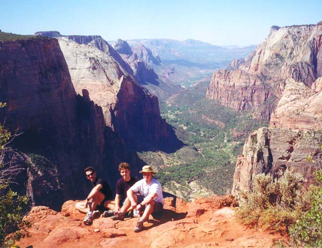
Start the long ascent from the Weeping Rock trailhead (37o16.27'N 112o56.33'W and elevation 4360ft) up the east wall of Zion Canyon by following the signs for the East Rim Trail. An early start is recommended not only because this is a long day hike but also because early in the morning most of the climb will be in the shade of the East Wall. As you rise there are spectacular views of the canyon features on the West Wall particularly Angels Landing. At one switchback the trail to Hidden Canyon rises off to the right. A few more switchbacks, and the trail passes around a bluff and contours into the pretty Echo Canyon. After crossing the streambed it then climbs the north wall of Echo, finally contouring out and reaching a trail junction where the right fork is the East Rim Trail. You fork left toward Observation Point. Another series of switchbacks and the trail finally reaches the rim of Zion Canyon and the edge of the Markagunt Plateau. It then levels out and follows the rim another half mile or so to the trail junction where the spur to Observation Point branches off to the left (elevation 6400ft). You should reach this point about 2hr from the start having covered 3.6mi. Though a side trip, it is well worth the extra effort to follow the level, 0.35mi trail over to Observation Point (37o16.70'N 112o56.44'W and elevation 6500ft), a sidetrip that adds about 30min to the hike. The reward is a spectacular view down Zion Canyon from high overhead.
 | 
| |
|---|---|---|
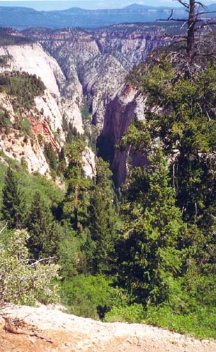
| Zion Canyon from Observation Point | Mystery Canyon from drop-in |
Back at the junction where you will now turn left (the right fork when approaching from below), study the topo map and note the time. From here it is 0.9mi to the use-trail turn-off for Mystery Canyon so it should take just about 20min to hike to that point. First the trail passes the head of a large canyon on the left. Shortly thereafter it contours around the head of a large canyon on the right. The trail then proceeds around a long turn to the left at the end of which you should be able to find a clear use-trail branching off to the left. After a few yards this takes you to a magnificent view high above Mystery Canyon slicing off to the north. (If the trail is longer than a few yards and if the view is not clearly Mystery Canyon then you followed the wrong use-trail.) You should reach this drop-in point (37o17.33'N 112o55.81'W and elevation 6760ft) about 2hr 45min from the start.
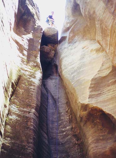
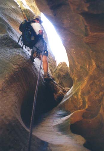
From this overlook, a steep, well-worn dirt trail descends into Mystery Canyon. After about 45min you begin to transition into a stream bed and, almost immediately, encounter a small, 20ft rappel for which you can either use the bolt anchor on the rock in midstream or the small tree on the right. From here you travel along the streambed in a long stretch of narrow but open, wooded canyon with growing walls of rock on either side. Scattered along this section are five small obstacles all of which can be bypassed by short use-trails on the right. Finally the walls close in and you find yourself in a dramatically descending slot. Quickly you encounter the first large rappel, an 80ft descent into the deepening canyon. Good bolts on the left wall make the entry fairly easy and the descent down a geometric groove is straightforward. You are now in a deep and narrow slot canyon with bare rock walls and a gravel, sand and rock bottom. About 7 other rappels follow in rapid succession as the slot canyon deepens still further and you can only see patches of sky high above you. All the rappel anchors have two good bolts and many are so close that you can feed the rope from one to the next. This part was also dry when we passed this way. The second rappel has a drop of about 40ft and an anchor in the right wall. The third is about 50ft and is followed by the small 15ft fourth. The fifth is a multistage 45ft rappel. During this series the canyon makes a 90 degree turn at 37o18.20'N 112o55.97'W and now heads west instead of north. After the fifth rappel it opens up very briefly before you again drop into a slot with a small 15ft rappel followed by a two-stage descent with a 40ft and then a 30ft drop.
 | 
| |
|---|---|---|
| 80ft rappel | Mark on rappel |
Once again the canyon opens up though the vegetation is more desert like than it was higher up. You then proceed down a long stretch of relatively open canyon that can be very hot on a summer afternoon. A flat-bottomed sandy stretch signals your approach to the Devil's Pool, a large muddy canyon-spanning pool of very variable depth that was formed by backup behind a huge rockslide of relatively recent making. Before you come to the rockslide itself you may have to wade through the Devil's Pool though it was completely dry when we passed this way. You should arrive at the rockslide itself about 6hr 45min into the hike. The easiest route up, over and down the rockslide is on the right hand side. At the base on the other side there is a small dryfall that must be bypassed by a use trail on the right. A brief section of open canyon follows; this has one 20ft rappel in the middle with a bolt anchor in the flat rock on the right.
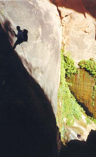
Shortly thereafter the canyon narrows again to bare rock and you arrive at the top of the largest and most dramatic rappel in this adventure, a drop of about 150ft in a grand vertical chamber to a deep pool far below. The best anchor for this descent both in terms of its multiple bolts and in terms of the rappel trajectory it produces is off on an inclined ledge on the left. The bolt on the chockstone in midstream leads to a trajectory that could get awkward because of another large chockstone that is barely visible far below. To reach the preferred anchor on the left you may choose because of the exposure either to hook into the bolts placed at intervals along the 30ft ledge or to set up a belay. But, on a dry summer day, reasonable care on the friction rock is all that is needed to make it over to the anchor. Unlike the preceding rappels, this is a single strand descent with your 60m rope so you will need to set up a recovery cord. You may wish to do as much rope assembly as possible before venturing out onto the ledge. Then all the first person needs to do is to feed the rope through the rappel rings. The descent then takes you down about 110ft onto the top of the previously mentioned chockstone and then down another 40ft into a very pretty pool at the bottom. Here you will need to make a swimming disconnect. This was the first water we encountered and it was great to cool off in the pool. Fed by Mystery Springs, the water was fresh and filterable and so we could finally replenish our water supply. You should reach this point about 8hr 15min from the start.
 | 
| |
|---|---|---|
| Big rappel | Descent into Zion Narrows |
The character of the canyon is now greatly changed by the continous
water supply. In contrast to the desert-like vegetation higher up,
the canyon is now lush and cool. Downstream from the Springs
there are several small pools and one 12ft drop into a beautiful,
deep pool with crystal water. This can be jumped or rappelled
using a tree anchor a short distance upstream of the lip.
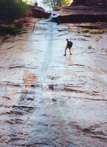
Finally, 8hr 45min from the start,
you arrive at the last rappel, a drop-off of about 120ft directly
into the Zion Narrows
(37o17.98'N 112o56.68'W).
The anchor is a tree on the left and, again,
you will need to set up a single strand rappel with a rope recovery
cord.
Moreover, because of the narrow cracks
in the rock where the rope crosses the lip, the last person down
needs to make sure the rope lies down to the right of those grooves
and cracks. Otherwise it may be very difficult to pull down the rope.
The rappel is wet
and the mossy rock is slippery so extra care is needed. You may choose
to do a sliding, free rappel.
You are also most likely to have an audience from the
crowds who wade upstream from the Riverside Walk to this point
in the Narrows. So, finally, 9hr into the hike, the technical
descents end here in the Zion Narrows. It is just a 400yd
walk downstream to the end of the concrete Riverside Walk
(37o17.80'N 112o56.90'W). Another mile
or so along the Walk brings you to the Temple of Sinawava
(37o17.11'N 112o56.86'W) and the
stop for the shuttle bus that will take you back back to your vehicle at
the Visitor Center.
Last updated 7/8/00.
Christopher E. Brennen