ADVENTURE HIKES AND CANYONEERING
IN THE SOUTHWEST
© Christopher Earls Brennen

|
|---|

|
Hike D12. Zion's Misery Canyon
- Hiking time: 9.5 hours
- Estimated hiking distance: 8.8 miles
- Elevation gain: 2420 feet
- USGS Topo Map: The Barracks
- Difficulties: About 5 rappels up to 70ft and much downclimbing and deep wading (swimming under some circumstances); some flash flood danger.
- Special equipment: One 50m rope, harnesses, helmets and rappeling gear, 50ft webbing, several rappel rings, dry bags (wetsuit on colder days), water filter.
- Permit: None needed.
-
ACA Rating: 3B IV

Characteristics
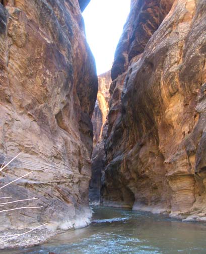
Misery Canyon is one of many nameless canyons on the map that lead down into Parunuweap Canyon wherein flows the East Fork of the Virgin River. This is rugged wilderness at the southeastern corner of Zion National Park with no roads worth the name between the Zion-Mt.Carmel Highway (Utah Highway 9) that leads east from the Park and Arizona border far to the south. The East Fork of the Virgin rises in the Long Valley north of Mt.Carmel and slices through the Markagunt Plateau by way of this deep canyon that John Wesley Powell first explored and named Parunuweap, the Paiute Indian name meaning ``roaring river canyon''. Parunuweap is a spectacular, vertical-walled abyss, up to 2500ft deep, that rivals the Zion Narrows. The river runs year round and mostly fills the breadth of the canyon bottom so one must hike in the opaque water which can be up to chest deep in places. This hike is one of the very few ways in which one can enjoy Parunuweap because the section of the canyon further downstream in Zion National Park is closed to public access; the section accessed by this hike is just outside the Park on BLM land and therefore open to the public.
However, Parunuweap is just one of the delights that this hike provides. The first part is a lovely cross-country hike across some of the loveliest scenery in Zion. Then it drops down into the West Fork of Misery Canyon where you descend a number of stretches of classic and winding sandstone slot with some rappels, many short downclimbs and a number of thigh deep wades. After joining the East Fork of Misery, you enter a deeper slot with deeper pools and eventually a fantastic subterranean grotto with a double arch and many pools. There used to be a tight squeeze here that led to the name ``Fat Man's Misery'' and hence to Misery Canyon but that feature is now gone. The grotto leads to the Parunuweap where you will need to travel downstream for 0.3mi to find the start of the climb back out of the abyss. The hike out involves a long, tough trail climb that can be very hot in the middle of the year.
Note that wetsuits are not necessary except on colder days. Note also that this hike does present some navigational challenges both on the outward and return legs so that a GPS and waypoints would be valuable though not necessary. A good map and compass are, however, essential.
Trailhead
The parking area for Misery Canyon is close to the larger parking area on the Zion-Mt.Carmel highway where people stop to view the Checkerboard Mesa (this is only about 0.3mi mile west of the National Park Entrance Station). Drive 0.5 miles west of the Checkerboard Mesa parking area to a place just west of Checkerboard Mesa itself where there is a small turnout on the right or north side of the road (37o13.60'N 112o53.11'W at an elevation of 5500ft).
Hike
From the turnout (elevation 5500ft) hike down the road (west) about 100yds to where it crosses the wash emerging from the large canyon to the west of Checkerboard Mesa. Hike up this sandy streambed as the canyon emerges from the steep gorge seperating Checkerboard Mesa from the cliffs to the west. After about a mile of gentle upward gradient, the canyon bottom steepens suddenly and you climb a sandy trail to the right of the streamcourse eventually reaching the saddle at the top of the pass (37o12.73'N 112o53.00'W). The elevation of the pass is 5900ft and you should reach this point 1hr and 1.1mi from the start.
A rough trail that avoids the streamcourse descends the other side of the pass; you will locate this over to the right of the saddle. After about 0.3mi this trail descends to the canyon bottom and crosses over to a low ridge on the far side. The trail which is fairly clear and often marked by cairns where it crosses slickrock, then contours around the base of the south side of Checkerboard Mesa. It descends gradually to cross the wash exiting the canyon on the east side of Checkerboard Mesa (2mi from the start at 5600ft) and then continues eastward to cross another wash (about 2.3mi from the start at 5560ft) exiting the next canyon to the east. From this second wash climb the ridge to the east. Just a short way up the ridge you may notice a cairned trail veering south. This is the return route and you should not follow this but proceed straight on in an easterly direction over the top of the ridge to where, on bare slickrock, you will encounter the steep drop-off into the West Fork of Misery Canyon. You should reach this drop-off about 2hr 15min and 2.5mi from the start.
The drop-off is substantial (about 300ft) and, in order to reach the canyon bottom, it is advisable to veer south along the edge and over a small bluff to where a slickrock bowl on the west side of the canyon makes the descent easier. In this descent we did make one 40ft rappel from a tree anchor. You should reach the bottom of the West Fork of Misery Canyon (elevation 5150ft) 2hr 40min and 2.8mi from the start.
 | 
| |
|---|---|---|
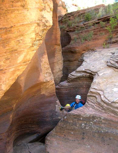
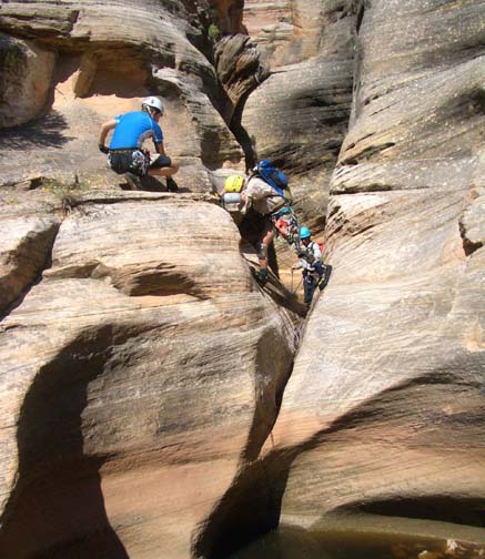
| Exiting slot in Misery Canyon | Between two potholes in Misery |
Hiking downcanyon you soon come to the first of the many short sections of slot narrows that occur at intervals during the descent of this canyon. This first slot begins with a 20ft rappel from an old, single overhead bolt (better to use some other anchor) into a neat, narrow slot with lots of twists and turns. After 15min you will exit this slot and after another 15min you enter the second, shorter slot. Another 30min will bring you to yet another section of slot, this one containing an awkward 10ft drop that may require a partner assist. Then about 4hr from the start at 4770ft you arrive at a 20ft rappel from a deadman anchor down into a broad slot area. This is followed by two large water filled potholes either or both of which could be keepers. The first was shallow for us and led to a short slot opening before the drop into the second pothole that looked difficult to climb out of. However a short climb to a ledge on the right allows you to bypass this pothole. From there it is just a few yards to the confluence with the East Fork of Misery Canyon. However, the West Fork has a substantial drop-off at the confluence and this necessitates a climb up to a tree anchor on the left which anchors a 70ft rappel down into the wash of the East Fork. You should arrive at this confluence with the East Fork of Misery Canyon (37o11.30'N 112o51.46'W, elevation 4700ft) about 4hrs 30min from the start having covered 3.9mi.
It is only about 100yds down Misery Canyon to a 40ft, two-stage rappel down into a deep slot from a boulder anchor on the left side. This leads to many wading pools (often very mucky) and finally to a deep grotto with a double arch. The water suddenly changes to a lighter colour as you approach the confluence with the Parunuweap. This grotto is a special place. The pools were just wadable when we went through but could be swimmers at other times. Then, at one short and narrow 6ft downclimb you encounter a warm spring emerging from the rockface on the left. Just a few short pools later you arrive at the Parunaweap (37o11.00'N 112o51.64'W), a spectacular vertical-walled canyon with a substantial stream flow that spans the entire canyon-bottom in many places. You should arrive at the Parunuweap (also known as the East Fork of the Virgin River) at an elevation of 4610ft) about 6hrs from the start having covered 4.3mi.
|
|---|
| Parunuweap Canyon
|
Once in the Parunuweap, hike and wade downstream for about 0.3mi to a point (37o10.87'N 112o51.76'W) where there is a steep, broken, brushy slope on the right that is the beginning of the return route. You may notice a cairn about 30ft up on a ledge on the right side. The trail starts up behind this rock. Before beginning the climb out of the canyon you should stock up with filtered water for the hike out can be very hot. Also, before leaving the Parunuweap, you may wish to proceed on downstream to just past the brushy slope where there is a plaque commemorating the exploration of the Parunuweap by Major Wesley Powell in 1872. The plaque reads: Memorial. Major John W. Powell (1834-1902), explorer-scientist. Stephen V. Jones (1840-1920), teacher-topographer. Pres. Joseph A. Young (1829-1873), Mormon pioneer leader. Descended Labyrinth Falls 1/2 mile below - Mon. Sep.30, 1872 during first Parunuweap Canyon traverse. Powell named this canyon from the Paiute Indian word Parunuweap which means "Roaring River Canyon". Dedicated Sep.30, 1972.
Returning to the exit trail,
the climb out is very steep in several places and takes you to a broad
saddle at
37o10.96'N 112o51.73'W and
4790ft. At the far side of this saddle you also look down on the
river.
From the saddle, contour and climb the slickrock on the left side and
proceed up to the trees overhead to find the trail again.
The exit trail proceeds in a generally northerly direction and is marked
fairly well by cairns though you may have to search for it several times.
The readily recognized form of the south end of Checkerboard Mesa provides
a welcome target though you should aim a little to the right of this.
Eventually the trail rises to a broad and bare slickrock summit where it
proceeds around to the left and joins the outgoing trail
at about 37o12.20'N 112o52.13'W. Follow that
back to the trailhead. It should take about 3hrs to complete this
return hike during which you will cover about 4.1mi so that the
total duration of the hike is about 9.5hrs
and the total distance is 8.8mi.
Last updated 10/10/05.
Christopher E. Brennen