ADVENTURE HIKES AND CANYONEERING
IN THE SOUTHWEST
© Christopher Earls Brennen

|
|---|

|
Hike K7. Malibu Canyon
- Hiking time: 4 hours
- Estimated hiking distance: 3.8 miles
- Elevation gain: 460 feet
- USGS Topo Map: Malibu Beach
- Difficulties: Much bouldering and some wading
- Special equipment: None
-
ACA Rating: 2A III

Characteristics
Malibu Creek State Park extends down through the great gorge of Malibu Canyon to the Pacific Ocean. It is a rugged and spectacular canyon wilderness whose solitude is broken by the seemingly continuous procession of vehicles that travel the road through the gorge high above the canyon bottom. That road means that there are many places where this adventure can be foreshortened but the canyon walls are quite precipitous and so the hiker would have to choose that exit route carefully.
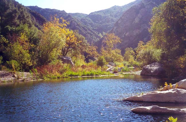
Malibu Creek drains the largest catchment area in the Santa Monica mountains and therefore a substantial stream runs in it year round. This stream supplies a rich riparian canyon bottom with many delightful pools and cascades. Many species of birds call this canyon home so look for a wide variety of ducks. Undoubtedly you will stir at least one great blue heron into flight and be able to watch it soar up the canyon to the next large pool. It is one of those canyon sights that never ceases to thrill me.
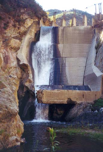
But every winter violent floods crash through this canyon, dislodging giant boulders, tearing out bushes and trees and leaving behind a very rugged canyon bottom. And so the going is hard with much bouldering and a lot of non-technical climbing. And half-way through the hike you will encounter the Rindge Dam that is quite easily bypassed as described below. This now-abandoned relic is a prime example of the folly of the civil engineers who, during the first part of the last century, seemed determined to dam every canyon they could find. Built in 1926 by the Rindge family who believed it was their right to do whatever they wished with the land, the 574acre reservoir behind the 100ft dam completely filled with sediment and gravel in less than 25 years. Since 1950 the stream has flowed over those gravel beds and has fallen directly over the dam. Sooner or later, this monstrous and unnatural obstruction will have to be removed, a task that will result in enormous damage to this lovely place for between 800,000 and 1,600,000 cubic yards of sediment would have to be removed. The alternative, which is to leave it to fail naturally, is unthinkable since the resulting debris flow would carry away most of the city of Malibu Beach. Thus an environmental nightmare is inevitable in Malibu Canyon. And so I urge you to enjoy this lovely place before the disaster occurs.
The hike is best undertaken in the summer or fall before substantial rain has fallen. A sizeable stream flows year round in Malibu Canyon and during the winter or spring the swollen river could make the hike much more difficult.
Trailhead
This adventure requires either a car shuttle or the placement of bicycles for the return along the road. The first trailhead is Tapia Park section of Malibu Creek State Park at 34o4.91'N 118o42.28'W. This is on the west side of Malibu Canyon Road (Highway N1), 5.1mi south of Highway 101 in Calabasas or 3.1mi north of Pacific Coast Highway (PCH) in Malibu. Leave a vehicle or bicycles there close to the road. Then drive 3.1mi south through Malibu Canyon to PCH; turn left, drive 1.3mi and turn left onto Serra Road. Follow Serra Road for 0.8mi and stay left at the fork. Proceed another 1.5mi and turn left onto Palm Canyon Lane. Drive 0.3mi to where Palm Canyon Lane turns right. Another 100yds or so brings you to the end of Palm Canyon Lane and the start of the Backbone Trail into Malibu Creek State Park (34o2.77'N 118o41.25'W). The residence owners along this final section of Palm Canyon Lane have posted many no parking signs so you may have difficulty finding a place to park. Clearly the Park administrators will have to address the difficulty in accessing this south end of the Park.
Hike
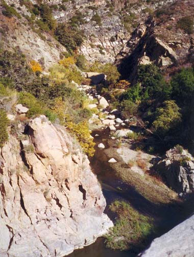
A good dirt road/trail proceeds north from the end of Palm Canyon Lane (elevation 30ft) and in no time you are in real wilderness. After just 150yds the trail crosses to the left side of the creek. Here it is difficult to avoid getting your feet wet; it is just the first of many occasions where wading is unavoidable. Just 100yds beyond the stream crossing the well-maintained trail forks. The left fork switchbacks up to Malibu Canyon Road, just a few hundred feet up the canyon wall. Take note of this locale for we will return by this trail at the end of the day. We take the right fork that proceeds up the canyon, but soon doubles back since it is mostly used by local horseriders. From here our route up the canyon is mostly trailless though occasionally there are short sections of use-trail that ease passage. As you proceed the going gets tougher and tougher, in places requiring bushwhacking, in others navigation around huge boulders. You will need to cross the river many times. Right up against the canyon walls you will sometimes find a crude use-trail but these inevitably end at some impassable obstacle. It is slow going, but eventually, 1hr 45min from the start at an elevation of 170ft, the canyon abruptly turns left and, rounding this corner, you get an awesome view of the Rindge Dam.
A few minutes later you are standing near the bottom of the dam looking up at its sheer walls (34o3.86'N 118o41.94'W. Actually there are two arch-like dams side by side with a great monolith of rock in between. Water flows through one of the old rusted and abandoned gates at the top of the left-hand dam and crashes majestically down about 100ft to the large pool at the base. The blue heron I had disturbed rose serenely from the pool and, high above me, made his way down the canyon. It is both a beautiful and terrible place.
On either side of the dam the rock walls of the canyon are vertical and unscaleable. It seems impossible that there would be an easy way to climb past this awesome obstruction. However, such is the case and to access the bottom end of this route you simple wade through the river to the first wooded gully downstream of the cliffs to the right of the dam. Climbing this gully, you should soon encounter a use-trail that veers to the left and ascends to a broad shoulder high above the north end of the dam. The trail then descends steeply to a point just upstream of the dam. You should reach this point about 2hr 15min from the start. From here you can easily access the 4ft wide concrete top of the northern dam and walk along to the top of the rock monolith in the center.
 | 
| |
|---|---|---|
| Downstream of dam | Left half of Rindge Dam |
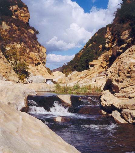
Once you have finished exploring the dam, the route upstream is an easy walk over the flat and mostly open gravel flats (elevation 290ft). These continue all the way to where the canyon turns north again. Then the going begins to get harder with more bushwhacking and bouldering. Approximately 3hr from the start at an elevation of 330ft you reach a point in the canyon directly below the south end of the tunnel on Malibu Canyon Road. Here there is an exciting stretch of bedrock narrows, extending about the same length as the tunnel. At the downstream end of these narrows at 34o4.18'N 118o42.40'W is a long and deep pool, the largest encountered during this hike and, during the summer, a great place to pause for a swim. The rockshelf to the left of this pool is easily negotiated but you must then cross to the right to bypass the next pool. Having done this you arrive at the most challenging single obstacle encountered during this hike. A small, 10ft waterfall plunges over a steep rock shelf from one deep pool to the next. Though you may be able to climb the shelf on the right, I chose the left side and tightroped across the top of the waterfall to surmount the obstacle.
 | 
| |
|---|---|---|
| Pool below narrows | Malibu Canyon Narrows |
The narrows end here, but there is still a stretch of bouldering left before the canyon begins to widen and flatten, signaling that you are approaching the end of the hike. About 3hr 50min from the start at an elevation of 470ft, you will encounter a dirt road that crosses the stream at 34o4.65'N 118o42.11'W. On the left is an intact water gauge. If you have had enough by this time, it is a short way up the dirt road to Malibu Canyon Road. However it is also a short way through the bushes to an open meadow that makes for more pleasant walking than the highway. If you decide to continue in the canyon, make sure to stay to the left as the canyon opens up. You will soon encounter and follow a dirt road that crosses the meadow and exits to Malibu Canyon Road just about 30yds south of the bridge over Malibu Creek. The return vehicles or bicycles are just across the bridge at 34o4.91'N 118o42.28'W.
If you deploy a return vehicle you should just follow the route
to Palm Canyon Lane driven earlier in the day. If, however, you choose
to bicycle back then, as mentioned earlier, there is a shorter and more
pleasant return route as follows.
Ride back down Malibu Canyon Road to the lowpoint in the
road just before you come to the built up area. Here, 3.1mi from
Tapia Park at 34o3.00'N 118o41.60'W and an elevation of about 230ft, at a point overlooking the
bottom section of the canyon, you should find a rudimentary gate leading
to a dirt road or trail heading down to the canyon bottom. In a few
hundred yards this emerges at the trail fork encountered just after
the start of the hike. A few minutes of off-trail riding and a stream
crossing
will then return you to the trailhead where you started at
34o2.77'N 118o41.25'W.
Last updated 12/1/00.
Christopher E. Brennen