ADVENTURE HIKES AND CANYONEERING
IN THE SOUTHWEST
© Christopher Earls Brennen

|
|---|

|
Hike B1. Maidenwater Canyon
- Hiking time: 8 hours
- Estimated hiking distance: 3.7 miles
- Elevation gain: 560 feet
- USGS Topo Map: Black Table
- Difficulties: Much downclimbing often requiring belays, seven rappels up to 30 feet, some waist deep wading
- Special equipment: 60 feet rope, 30 feet webbing, 8 rappel rings, full rappelling equipment, gloves, dry bag, headlamp
-
ACA Rating: 3B III

Characteristics
The southeastern corner of Utah is a scorched wilderness of sandstone rock, crevassed by the movement of the earth, wind and water and baked by the searing summer sun. Not much lives here: a few hardy shrubs and small animals capable of finding coolness deep within the ground. Some pioneers survived their travels through this land; virtually none stayed for it was not possible to live here. When the Glen Canyon Dam was completed, Lake Powell flooded a spidery maze of canyons and men came by boat to enjoy the beauty of the rock and the water. Roads were cut and paved to allow access to marinas within this network and the beauty of the wilderness surrounding Lake Powell began to be appreciated and enjoyed.
It is a landscape of huge vistas with great redstone cliffs and flat mesas as far as the eye can see. The relief is dominated by the enormous canyons cut by the Colorado river. But that great river also has thousands of tributaries. Each of these has its own canyons, often extremely deep and narrow because of the special way in which the storm water runs off this bare land and cuts deep slots through the slickrock. And so for a huge area, this land is riven through with narrow slot canyons, places of special beauty and adventure. In this collection, we describe descents through several of the slots accessible from Utah Highway 95, the road that runs from Hanksville down to the Hite crossing of the Colorado. Here we feature Maidenwater Canyon which originates in the foothills of the Henry mountains and joins Trachyte Creek on its way to Lake Powell. It is accessible because Utah Highway 276 branches off from Highway 95 to service Bullfrog Marina on the shores of the lake and crosses Maidenwater on the way.
Maidenwater Canyon is narrow in places, sometimes no more than 2ft in width. The descent requires about seven short rappels and a great deal of downclimbing with chimneying, stemming and body-jamming. Some of the downclimbing is quite challenging and many will want a belay to prevent any mishaps. It is useful to keep a 30ft piece of webbing available for this purpose. Because of all this downclimbing, it is advisable to wear old clothes.
The hike is best undertaken in the spring or fall in order to avoid the 100 degree plus heat of the summer (though it is cooler in the shaded sections of the canyon). However, the danger of flash floods is extreme and so you should keep a sharp eye out for thunderstorms, particularly late in the day. Even in summer, there are waist deep pools to wade and there may even be a swim so a small dry bag for valuables is recommended.
Trailhead
From the junction of Highway UT 276 and Highway UT 95 (26mi southeast of Hanksville, Utah), drive south on UT 276 for 9.4mi to where the road dips down to cross an embankment over the South Fork of Maidenwater Canyon. Mile marker 9.4 is nearby. Park in one of the small dirt turn-offs just south of the crossing of Maidenwater (37o53.62'N 110o34.17'W).
Hike
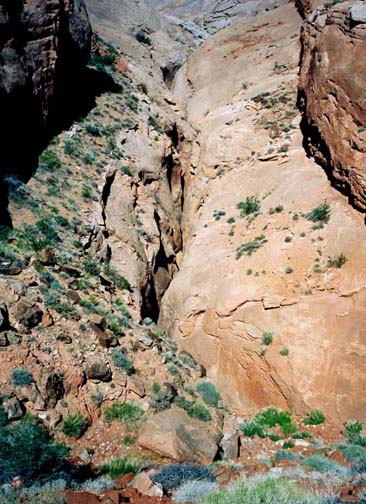
Access to the South Fork of Maidenwater Canyon is gained by hiking up the ridge and rim on the north side of the canyon. From the point where the road crosses the canyon by means of a substantial rockfilled embankment, hike north along the road for about 400yds, counting the low ridges on the left or west side. Though it is not critical, the third low ridge provides the best route (37o53.84'N 110o34.28'W). Hike up the apex of the ridge. It merges into a more significant ridge separating the South Fork of Maidenwater from the Middle Fork which soon becomes visible on your right. A small subfork of the South Fork is evident on the left but you soon contour around the head of this. Passing up over a broad flat shoulder while following the rim of the South Fork, you find yourself hiking a wide shelf between the canyon and a line of pock-marked cliffs. About 1hr and 2mi from the start at an elevation of about 5210ft you will come to the obvious head of the canyon, defined almost everywhere by a 50ft plus cliff. Walk around the head of the canyon to the south side and then continue along that side for about 150yds to where there is a break in the cliff and a dead tree (37o53.53'N 110o35.74'W). An easy downclimb and a single cairn will bring you to a small but steep slickrock downclimb whose descent places you on a sand and scree covered shelf. Turn left and hike along the shelf to the canyon bottom.
 | 
| |
|---|---|---|
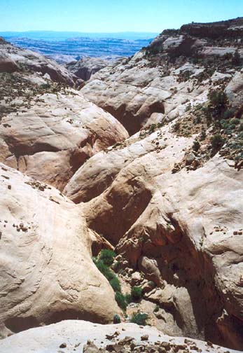
| View of canyon from road embankment | View of Maidenwater near canyon head |
Heading downstream in the canyon bed, the downclimbing starts immediately and, within minutes, you come to the first rappel, a 20ft drop from a deadman anchor (elevation 5090ft). The canyon is narrow right from the start but never becomes a really narrow slot like the nearby Irish canyons (see Blarney and Leprechaun Canyons). Maidenwater does, however, have lots of downclimbing, some of it quite challenging. Many will want frequent belays and it is useful to keep a 30ft piece of webbing available for this purpose. Note that the tough downclimbs occur more often toward the end of the canyon.
 | 
| |
|---|---|---|
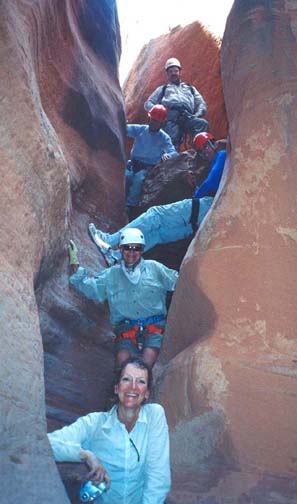
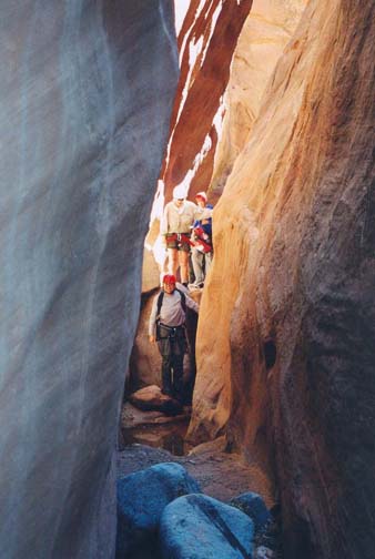
| Group in twisting slot | Near the end of Maidenwater Canyon |
A little over 2hr from the start and not far below the first rappel, you will encounter the second, a 15ft descent using a chockstone anchor. Note that when we passed this way all the rappels had webbing and rappel ring anchors that were in fair condition though the webbing will need replacement before next year. The third rappel is not far distant and is again provided with a chockstone anchor. It is a short 12ft drop but has a very awkward entry. More downclimbing and then, 3hr from the start at an elevation of 4960ft, you arrive at the fourth rappel, a 15ft drop from a deadman anchor. The fifth rappel follows shortly and comprises a 20ft drop from a chockstone anchor. Just below this point there is a pretty downclimb in a twisting slot that ends in a cool and normally dry pothole that makes a pleasant place for lunch.
Downstream of the dry pothole, the downclimbing gets tougher and more frequent. At 4890ft and a net 4hr from the start you will encounter an awkward 12ft downclimb. About 30min later there is a tough 20ft chimney downclimb into a pool. Then a little over 5hr from the start there is some welcome variation as the canyon broadens briefly with a large amphitheater on the left. But the walls soon close in again and there is a 15ft downclimb to negotiate, followed by the sixth rappel at 4770ft elevation. This is a 25ft rappel from a chockstone anchor into a 4ft deep pool that turns right and disappears before ending. This wet rappel is followed by an easy stretch free of substantial downclimbs at the end of which the canyon opens up and you catch your first view of the road embankment about 100yds ahead of you. Soon however, you drop down into the final section of slot that contains three tricky downclimbs including one of about 20ft where most people will want a belay. It is just a few yards from this downclimb to the top of the seventh and last rappel.
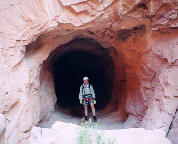
|
|---|
| Tunnel under the road |
You should reach this last rappel about 7.5hr from the start. There is a webbing anchor fixed behind a big boulder on the left side; the drop is about 30ft down into a dark slot. The slot contains several more downclimbs and one dry but potentially deep pothole before you arrive abruptly at the entrance to the tunnel through the road embankment (37o53.69'N 110o34.20'W). The tunnel is only about 100yds long and plenty high enough to walk through without stooping. However, even though you can see the light at the other end, it is important to don your headlamp before proceeding since the tunnel floor is rough and there is a 4ft deep trench on the right side about 2/3 of the way through. Upon exiting the tunnel turn immediately left and climb the scree to the road and the end of the hike.
Though the hike covers only about 3.7mi it will take a moderate group
about 8hr of hiking to complete.
Last updated 6/14/04.
Christopher E. Brennen