ADVENTURE HIKES AND CANYONEERING
IN THE SOUTHWEST
© Christopher Earls Brennen

|
|---|

|
Hike K21. Kelso Dunes
- Hiking time: 3 hours
- Estimated hiking distance: 5 miles
- Elevation gain: 560 feet
- USGS Topo Map: Kelso Dunes
- Difficulties: Blowing sand
- Special equipment: Goggles
-
ACA Rating: 1A II

Characteristics
Out in the vastness of California's Mohave Desert, in a place where no-one lives and few ever venture, there is a 40 mile stretch of windblown sand dune known as the Kelso Dunes. Superficially there is nothing unusual or surprising about these dunes unless you happen to be nearby at one of those special times when these dunes emit the most amazing and other-worldly noise, a loud low-frequency rumble that, as yet, defies scientific explanation. In the geological literature they are known as "booming dunes"; the phenomenon occurs at only about 30 sites around the world and is the subject of much primitive legend and myth wherever they are found. What is known is that the noise is emitted when the steep slope on the leeward side of the crest is built beyond its maximum sustainable gradient and then fails, generating an avalanche of sand. Somehow this avalanche triggers a deep resonance within the dune that emerges as an eerie, single tone that can continue for several minutes and can be heard for miles around.
This adventure seeks to experience this incredible natural phenomenon. We climb to the top of the highest of the Kelso Dunes and set off the booming by creating our own sand avalanche. During the adventure we also get to experience the Mohave Desert at its wildest and most primitive. Though the trip could be taken any time during the year it is best during the winter months when the temperatures are moderate.
Trailhead
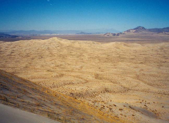
Interstate 40 crosses the Mohave Desert in California from the city of Barstow to the town of Needles on the Colorado River, a stretch of 144mi road with only a few small outposts of human presence. Travelling east from Barstow for 51mi you pass the wayside stop called Ludlow, where you should fill up with gas and other supplies. Another 26mi east of Ludlow, you should leave the highway at the well-marked Kel-Baker Road exit and turn left to travel north on this good two-lane asphalt road. Almost immediately you enter the Mohave National Preserve. The Kel-Baker Road climbs gradually toward a saddle in the Granite Mountains which, once reached, reveals a broad vista to the north. The bright yellow Kelso Dunes are clearly visible in the distance; they are scattered over a flat plain and stretch away beyond the northwestern horizon. They end at the bottom of a long and gradual slope stretching down from the mountains you have just passed through. They do not appear to be piled up against those mountains. The Kel-Baker Road proceeds northwards from the saddle down the gradually sloping and flat alluvial plain. The turn-off to the Kelso Dunes viewpoint is 100yds past an easily recognized pumping station on the left side of the road. Turn left onto an excellent, smooth dirt road that heads west; after 3mi you come to the restrooms, sign boards and parking area (34o53.48'N 115o42.19'W) that constitute the trailhead welcome at the Kelso Dunes.
Hike
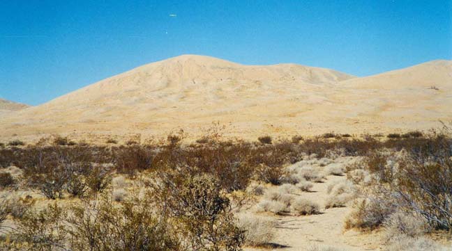
Though the wind direction often changes, the most common is a wind from the west that, far to the west, funnels down the wash of the Mohave River, through a narrow canyon and out onto a broad flood plain that stretches off to the ESE for almost 40mi. The sand carried along this route over many eons has piled up in a series of dunes, the last and largest of which lies in an EW direction just to the north of where you are now parked. You see it as a dramatic ridge of dunes about 2mi out across the sand. The highest peak along the ridge bears about 295 degrees magnetic from the trailhead. Since magnetic north is here about 13.5 degrees east of north, the actual bearing from the trailhead to the highest peak is about 308 degrees. Though it appears quite close, be warned that the summit is over 2mi from the trailhead and 560ft higher in elevation.
|
|---|
| Kelso Dunes from the trailhead |
From the trailhead (34o53.48'N 115o42.19'W) a use-trail heads directly toward the peak; the trail peters out after just 200yds where you cross the quite distinct edge of the sand dune material. You then cross a series of low dunes most with sparse grass-like vegetation. These gradually increase in height and in elevation and the vegetation becomes thinner. Hiking through soft sand on steep slopes is not easy and so this is a more difficult hike than might have been imagined. Where the sand has been disturbed (for example along the trail) or recently deposited (on the steeper lee slopes of both the large and small dunes) it yields easily underfoot making it hard going when hiking. However on the tops of the small and moderately-sized foothill dunes where the surface has been scoured by the wind the surface is markedly different. First it is quite firm underfoot and therefore much easier to hike on. Second, it looks quite different, having more visible black grains (volcanic rock grains?) like the black sand in Hawaii. This gives that surface a gray color, sometimes in bands running roughly normal to the direction of sand transport. This coloration is in marked contrast to the light yellow color of the steep lee slopes. It seems that a process of sand sorting is occurring on these small and moderately-sized foothill dunes. The small grains (yellow colored) are being preferentially removed from the relatively flat tops and deposited on the steep lee slopes thus leaving a greater proportion of the larger black grains behind to produce the gray coloration.
 | 
| |
|---|---|---|
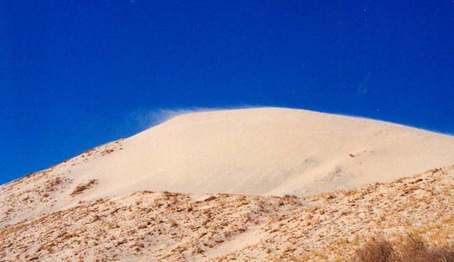
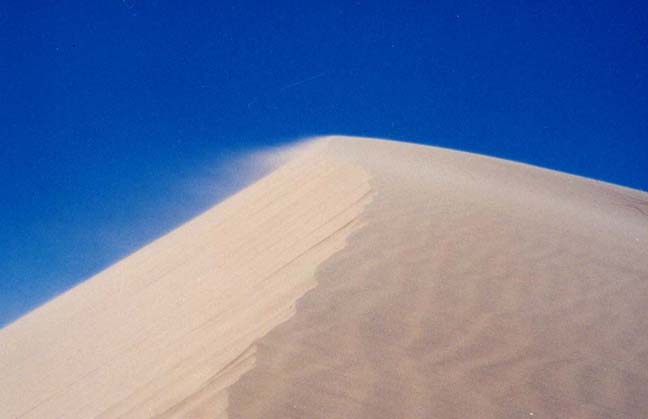
| Windblown sand and the steep lee slope | Close-up of the crest |
The route steepens markedly as you approach the bottom of the steep slope leading up to the crestline. There are clearly two common routes leading to the highest point. One is the direct route that necessitates a long and very steep final climb to the summit. We took the alternate which was to head for the saddle to the east of the highest point. By following the firmer, gray-tops of the foothill dunes we climbed to within about 20ft of the crest at a saddle about 75yds east of the summit. The last 20ft climb up to the crest was through very loose lee-side sand which made for hard climbing. My impression was that the sharp crest of the dune consists of a steep pile of very fine sand sitting like a triangular cross-sectioned dike on top of a lower ridge of firmer, less-mobile sand. The wind (from the north on the day we were there) seems to carry only the very smallest grains to the crest. There the particles become airborne and are deposited by falling onto the very steep lee slope. The ridgetop geometry is extremely uniform and well-defined; it extends for miles in both the east and west directions. In cross-section the crest consists of a fairly steep windward slope, a small flatter area on the top, a sharp break and then the very steep leeward slope (30-45 degrees). Once we reached the crest at the saddle, we trudged the additional 75yds to the highest peak, arriving there 1hr 20min after leaving the trailhead. The summit (34o54.22'N 115o43.10'W) had the added feature that it was at the junction of the main crest and a subsiduary crest that proceeded steeply down the south facing slope in a southwesterly direction. This is caused by wind blowing both over and around the peak.
The wind on the crest was much stronger than we experienced even 100ft below the crest. Sand was blowing everywhere, getting into everything. When I sat down to rest the density of wind blown sand impacting my face was much greater than when I was standing. Thus I estimate that the thickness of the blowing sand layer on the windward side at the crest was of the order of 3-4ft. This sand is then projected (roughly horizontally) over the top of the lee slope and cascades down onto the steep leeward slope.
 | 
| |
|---|---|---|
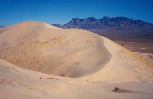
| View along the crest | Looking north from the summit |
This leeward slope at the ridgeline is so steep that by kicking on the crest one could generate a small landslide (perhaps 2-3ft in width) that would proceed slowly almost viscously down the lee slope. The typical speed of this landslide was no more than about 1ft/s. But it would continue (unexpectedly) for minutes, usually until it reached the bottom of the lee slope. These landslides also occur naturally without human intervention. They produce lateral striations all the way across the lee slope. We also observed these landslides on the lee slopes of the foothill dunes. However, during our entire climb we could hear no sound from any of these naturally occurring landslides and so began to speculate on why we could hear no "booming". Perhaps, we thought, the day was too cold for booming.
After a pause, we decided to head straight down the lee slope from the summit on our way back to the trailhead. The only way to do this was to sit down and slide. Within a few feet of descent we had set into motion a large area of sand and then it happened. There emerged from under us the most awesome rumbling tone, increasing in volume as we continued to slide and persisting as long as the mass of sand was moving. It was an eerie and other-worldly experience. The whole dune seemed to shake as though, deep within, there was a large resonating cavity. This sound continued as we descended the 150ft steep lee slope but became more muted. About 50ft down from the summit we encountered a slope with some vegetation but still very steep. Even on this slope we could still detect the booming though it virtually disappeared near the bottom of the steep lee slope. From there we started the hike back to the trailhead.
On the way back to the trailhead we tried several times to make the lee slope of
foothill dunes boom. We detected only very slight squeaking noise, never
the low frequency boom that so awed us at the summit. The total time for
the hike was about 3hrs.
Last updated 2/15/02.
Christopher E. Brennen