ADVENTURE HIKES AND CANYONEERING
IN THE SOUTHWEST
© Christopher Earls Brennen

|
|---|

|
Hike G9. Keane Canyon, Death Valley
- Hiking time: 6.5 hours
- Estimated hiking distance: 5.3 miles
- Elevation gain: 640 feet
- Topo Map: Chloride City
- Difficulties: Seven rappels up to 120ft rappel, some downclimbing
- Special equipment: 200ft rope, 160ft recovery cord, 80ft webbing, seven rappel rings or quicklinks, rapelling equipment, helmet
-
ACA Rating: 3A III

Comment:
Please note that at the time of writing the National Park Service has closed the area around the Keane Wonder Mine because of mine safety hazards. Check with the Park Service before undertaking this descent.
Characteristics
Death Valley National Park contains some of the most rugged and fantastic land in the world. That wonderland provides some marvellous adventures and canyoneering experiences. Though the heat in the summer is intolerable, the Park has the advantage that the mild winter weather allows outdoor activity when much of the rest of the southwest is too cold and wintery. While it does occasionally rain in the valleys and snow often covers the high peaks in the winter, at lower elevations the temperatures are perfect for exploring the many narrow, multicolored canyons that line both sides of the flat valley bottom. If you plan to do much hiking in the Park, I strongly recommend you buy Michel Digonnet's excellent book "Hiking Death Valley".
This particular hike combines two of the most attractive and interesting features of the Park. First it involves a moderate canyoneering challenge with about seven rappels up to 120ft in height (two of the larger drops are optional). But, in addition, the hike involves visits to some of the most interesting and extensive mining remains in the Park. In particular you will enjoy an extended visit to the remains of the Big Bell Mine and all its paraphenalia.
Trailhead
This hike requires a long high-clearance (or 4WD) shuttle and the preferred strategy may be to place the return vehicle the evening before and to camp at the top that night. To place the return vehicle first drive to a point on the Beatty Cutoff 4.3mi south of the Hell's Gate entrance station on highway 374 (the road out of the Park to Beatty, Nevada). Here at 36o39.98'N 116o57.20'W you will find the marked turn-off to the dirt road that leads to the Keane Wonder Mine trailhead. Proceed north up this good dirt road for 2.7mi to the Keane Wonder Mine trailhead parking area at 36o40.06'N 116o54.58'W and an elevation of 1320ft. Leave the return vehicle(s) here.
Then, in the other vehicle(s), proceed back to the asphalt road, turn right and drive uphill to the Hell's Gate junction with route 374. Continue east on 374 toward Beatty (passing over the unmarked Daylight Pass) and 10.5 mi from Hell's Gate you should come to the sign at the Nevada/California border at 36o49.94'N 116o52.81'W. Turn right here onto an unmarked dirt road (high clearance needed) and proceed south for 6.8mi to a tee-junction at 36o44.82'N 116o49.88'W where you turn right and proceed southwest for another 4.0mi, re-entering Death Valley Nation Park along the way. The going gets better as you proceed along this section of dirt road. At the end of the 4.0mi you arrive at a road fork at 36o43.07'N 116o53.03'W and an elevation of 4360ft.
The route for this hike climbs steeply for 1.8mi up the much rougher left fork at this junction and therefore requires 4WD. Since you would need to drive this three times, my recommendation would be to overnight (or park) at the junction and to hike rather than drive this last 1.8mi to the drop-in. If you decide to drive then subtract 1.8mi from the distances and 1hr from the elapsed times given below. However I note that the total time is about the same for the two modes of travel.
Hike
From the junction where you parked (36o43.07'N 116o53.03'W and elevation 4360ft) hike up the left fork as it switchbacks up the hill for about 400ft elevation gain. It then levels out and contours around to the site of mining town of Chloride City. Continue on the obvious main route through Chloride City and follow the road as it climbs again toward a low saddle at 36o41.95'N 116o52.66'W and an elevation of 5000ft. It will take about 1hr to reach this low saddle that is 1.8mi from the parking junction. At the saddle roads go to right, left and straight on. Go straight on and down 50yds into a shallow gully where you turn right and follow the trail down the gully. You are now in Keane Canyon.
The route down the canyon is littered with debris from the mining days when this whole area was overrun with activity. Empty, rusted food cans are particularly evident today along with the remains of many wooden structures. The uppermost section of this canyon was once a well-travelled trail though about 0.2m down the canyon the trail leaves the canyon on the left. At this point the rocky trail foundation is particularly evident. Beyond this point the route down the canyon becomes a little harder with much downclimbing. After about 40min of down-canyon travel (1hr 40min from the start) at an elevation of 4100ft you will come to the most difficult of these downclimbs. The streambed drops about 30ft but most of this is readily downclimbed; the last 10ft are trickier though there are many good footholds under the last lip. Alternatively you might choose to rappel using one of the good boulder anchors at the top.
 | 
|
|---|
 | 
| |
|---|---|---|
| The Big Bell Mine | ||
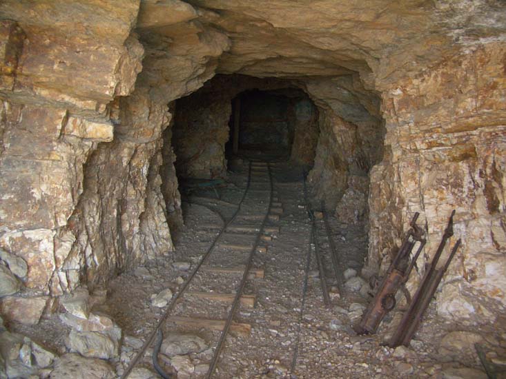
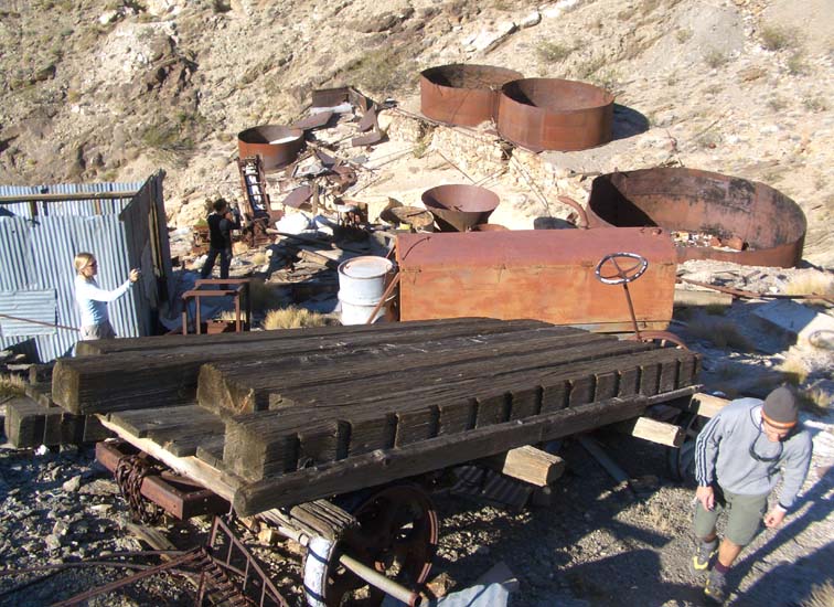
About 20min later and 2hrs from the morning start you round a right hand bend and come to the marvellous remains of the Big Bell Mine at 36o41.56'N 116o53.69'W, an elevation of 3720ft and 2.9mi from the start. On the left side of the canyon bottom stand the ball mill and the lower terminus of the aerial tramway that transported the ore from the mines high on the right or north side of the canyon. A trail on the right leads to the mine shafts where the ore (staurolite and biotite pelitic schist from the Crystal Spring formation) was extracted and conveyed by rail to an ore bin on the edge of the canyon. From there it was transported across the canyon by aerial tramway to the ball mill on the left or south side of the canyon. The milling complex is dominated by the remains of the ball mill and its ore bin. A little below are a number of large water and cyanide tanks as well as a great array of equipment including a Mack truck that that was used to transport the processed ore up the mountain to Chloride Cliff. The truck was winched up the cable road on the steep ridge behind the mill. Also worth visiting are the living quarters on the ridge top above the mine shafts on the north side. They consisted of a cluster of cabins and kitchens built on the terraced hillside and surrounded by a short stone wall for protection against the strong winds.
The Big Bell Mine has a colorful history. In 1904, two miners, Mike Sullivan and Johnnie Cyty, spurred by the success of the Keane Wonder Mine further down the mountain, recorded the ten claims that became the Big Bell Mine. Cyty was a particularly eccentric character known as "Johnnie-behind-the-gun" for his trigger happy tendencies. Work on the mine continued through 1907 until the fate of the Big Bell Mine took a sudden turn when Cyty lost his 250,000 shares in a night-long roulette game in one of Rhyolite's gambling saloons. Cyty then turned his efforts to a mine further north but got in a dispute over that claim with a man named Kyle Smith whom he shot dead in a classic western gunfight. He was convicted of manslaughter but won his appeal and walked free. The Big Bell Mine was never really successful and remained idle for many years until 1935 when it underwent major development by the Coen Company. However, their returns were meagre and the mine was finally shut down in 1937. (We spent about 45min at the mine and this time is included in the elapsed and hiking times.)
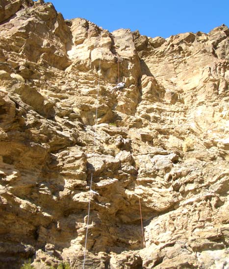
Downstream of the mine the canyon is fairly gentle until you rather abruptly come to two big vertical drops that make for fun rappels but can both be bypassed by following the trail on the left side. You arrive at the first of these vertical drops at 3390ft about 3hrs from the morning start. Several boulders just back from the lip can be used as anchor for this 100ft rappel. Below this it is only about 100yds to the top of the second of these rappels, again anchored by a boulder pile close to the lip. This second rappel drops about 120ft; the face of this rappel has much loose rock so watch for that while you are waiting at the bottom.
Below these two rappels the canyon gradient eases; the bypass trail comes down to the canyon bottom on the left and makes for easy travelling for a bit. Eventually, at 2780ft and about 4hrs and 3.6mi from the start you will come to the remains of a broken, loose rock dam and, just beyond that, a large canyon comes in on the left. Here a well-maintained trail begins to contour up the right wall of the canyon on its way to the Keane Wonder Mine. However, you do not take this trail but continue down the wash for a short way before contouring over to the right and using a lower trail to descend a short cliff in the canyon bottom. As you descend this trail look over to the left to see the remains of a stone dwelling under the short cliff.
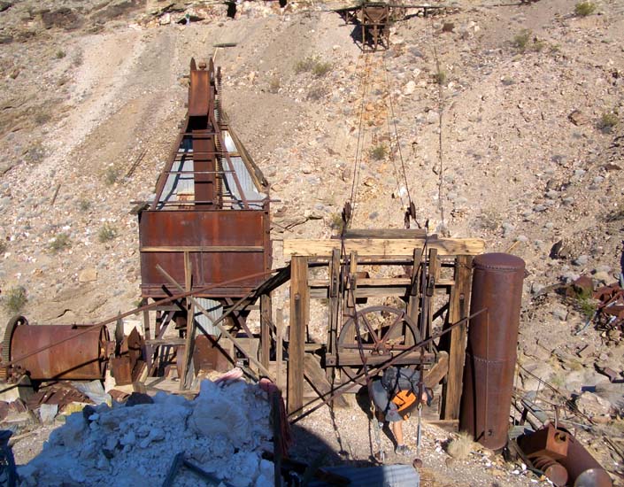
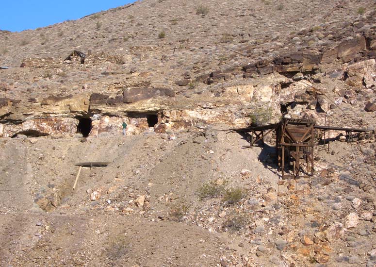
Continuing down canyon at 2290ft and 4.5hrs from the start you pass below the remnants of the Keane Wonder Mine, one structure of which has been visible for some time above the right wall of the canyon. Moreover, from here on the remains of the bucket aerial tramway that carried the ore from the Keane Wonder Mine down to the Keane Wonder Mill at the canyon exit are plainly evident and litter the canyon bottom. The Keane Wonder Mine was one of the most profitable mines in all of Death Valley. It was discovered in 1904 by partners Jack Keane from Ireland and Domingo Etcharren. When they uncovered a surprisingly rich vein of gold, they developed their claim and then sold it for around $45,000. Domingo bought a store in Darwin. On the other hand, Jack Keane returned to his native Ireland. There he murdered a man and spent 17 years in prison.
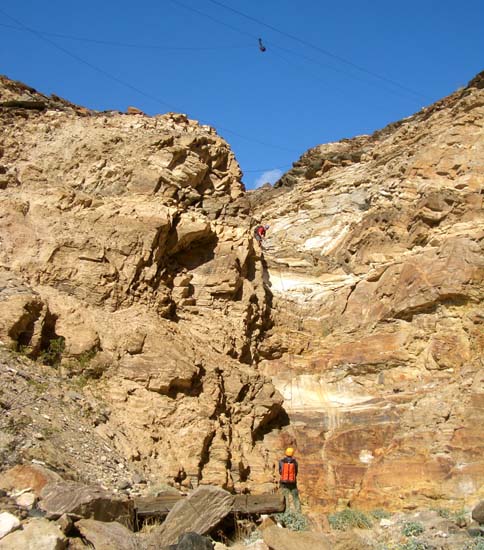
Beyond the Keane Wonder Mine the canyon begins to become more precipitous. After a series of white bedrock downclimbs you will arrive about 4hrs 50min after the morning start at the top of an 80ft rappel at an elevation of about 1970ft. This 80ft rappel is anchored by a piton low in the left wall and, further back and higher, by a large chockstone in the left wall. Notice the bucket on the cable high overhead!
 | 
| |
|---|---|---|
| Second large rappel (120ft) | 80ft rappel with overhead bucket |
More rappels follow in fairly rapid succession. First at 1860ft there is a 20ft rappel in a slot that could be downclimbed on the left side. A good strategy is for the best climber to be last on this descent having body anchored the other hikers. Just a short distance downstream at 1840ft you come to a 50ft rappel strewn with cables that can be anchored from a rock horn in the left wall. This is immediately followed by a 100ft rappel from a big boulder anchor on the right side of the lip. The polished rock here means a slippery entry to a rappel that is mostly overhung and free. A few hundred yards of gravel wash then lead to the top of the last necessary rappel at 1560ft, namely a 35ft drop from a boulder anchor on a shelf on the left side. There are two more drops left but both can be bypassed on the left. The first is a neat 40ft drop down a slot in polished white rock and the last is a short 20ft slot drop.
These last two bypasses bring you to the canyon exit where you pass the
remains of the Keane Wonder Mill up on a rise on your right at
36o40.18'N 116o54.46'W. It is worth a short
climb up the scree to see these ruins close-up. Finally, a short walk down
the access road brings you to the trailhead parking area and your return
vehicle(s) at
36o40.06'N 116o54.58'W
and an elevation of 1320ft. You should reach this point about
6.5hrs from the start having covered 5.3mi.
Last updated 11/11/07.
Christopher E. Brennen