ADVENTURE HIKES AND CANYONEERING
IN THE SOUTHWEST
© Christopher Earls Brennen

|
|---|

|
Hike R1. Mount Katahdin, Maine
- Hiking time: 9.5 hours
- Estimated hiking distance: 9.0 miles plus 2.2 miles road return
- Elevation gain: 3890 feet
- Topo Maps: Mount Katahdin, Abol Pond
- Difficulties: Substantial boulder climbing and descending, cold weather on summit
- Special equipment: Leather gloves, rain gear, warm clothing
Characteristics
The local Penobscot Indians feared the mountain, believing it to be the home of the storm god Pamola, who would wreak vengence on those foolhardy enough to venture onto its slopes. They called it ``Katahdin'' or ``The Greatest Mountain'', the name by which it is known in modern times. To this day, those who venture onto its heights are likely to experience Pamola's wrath for at these latitudes in northern Maine, the weather worsens rapidly with altitude and can change radically in just a few hours. However, this is a spectacular mountain for those strong enough to ascend (and descend) its steep slopes and to brave its vicarious weather.
In 1689, a teenage colonial by the name of John Giles was captured by the Abenaki native Americans near Portland, Maine, and was probably the first white person to lay eyes on Katahdin when he was taken on Abenaki hunting expeditions up the various branches of the Penobscot river. The first recorded ascent of "Catahrdin" was by Massachusetts surveyor Charles Turner, Jr. who summitted the mountain in August 1804. In the 1840s Henry David Thoreau made the top of the mountain he refers to as "Ktaadn" in "The Maine Woods".
Katahdin is located in northern Maine in Baxter State Park, named after the governor of Maine under whom the park was established. The nearest town is Millinocket, some 25 miles to the southeast. It lies between two forks of the Penobscot river and is mostly surrounded by land with numerous lakes. The mountain is part of an underground intrusion of magma or ``lacolith'' and is ringed by four cirques carved into the granite by alpine glaciers. Black bear, deer and moose inhabit the surrounding forests as well as many smaller creatures and a wide variety of birds (as well as voracious black flies and mosquitoes in the spring).
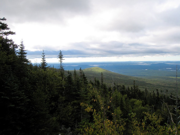
The summit of Katahdin is comprised of several peaks including Baxter Peak, Pamola Peak and South Peak. Of these the highest is Baxter Peak (5267ft); it also the northern terminus of the Appalachian Trail that approaches from the southwest and is also called the Hunt Trail on Katahdin. Though there is a broad plateau to the southwest of the peaks the rest of the topography consists of steep, granite rock slides which one must surmount to gain the peak. There are a number of steep trails principally those that originate at the Roaring Brook Campground and Trailhead to the east of the summit, from the Abol Campground and Trailhead to the south and from the Katahdin Stream Campground and Trailhead to the southwest. All begin in beautiful forested and lake-strewn terrain and climb above the tree-line into cold and rocky tundra above about 4000ft elevation.
Trailhead
Katahdin is approached from Interstate 95 in northern Maine by taking the Millinocket exit and driving west on Route 157 to the town of Millinocket. Since there are few services closer to or in the park, Millinocket will be your base for any exploration of the southern section of Baxter State Park, the location of Mount Katahdin. From Millinocket follow Route 157 westwards through two sets of traffic lights. Shortly thereafter Routes 11 and 157 split. Stay right on Route 157 and drive about 14 miles to the entrance station for Baxter State Park (Route 157 ends at the park). Here you will need to show your parking and camping permits and pay the park entrance fee. The ranger on duty will provide you with the parking sticker specific for your parking reservation. Just beyond the entrance the dirt road forks. The right fork goes to the Roaring Brook Campground and the trailheads that lead up the mountain from that campground. For the hike described here you take the left fork toward the Abol Campground and trailhead; this is a 2.2 mile drive from the entrance station along a smooth dirt road.
At the Abol trailhead (45o52.43'N 68o57.84'W and 1294ft elevation) you must register at the ranger station where you will record your return at the end of the hike. If you have not already obtained a topo map these can be purchased at the ranger station. The Abol trail begins just beyond the campground.
Hike
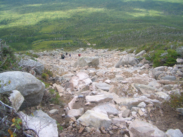
Beyond the campground and the Abol trailhead (35o1.85'N 116o19.78'W, elevation 1294ft), the trail proceeds through the forest, gently rising as it approaches the base of the mountain. After about 40min at about 2000ft the trail begins to steepen with many natural rock steps and, 1hr 20min from the start at 2700ft elevation you climb out of the forest at the base of the notorious Abol rock slide. This is a steep and broad rock slide about 1700ft high and represents the major obstacle in the climb of Katahdin. You should pace yourself as you ascend straight up. At the bottom the surface is mostly a mixture of gravel and smaller rocks but, as you ascend the rocks become large boulders that are a little more challenging to surmount. Follow the obvious blue blazes that mark the trail in order to find the easiest route. As you climb you see above you the larger boulders and cliffs near the top of the slide and when you finally reach them and ascend the last part of the Abol Slide, you quite abruptly find yourself on the wide plateau to the southwest of the peaks. This plateau rises much more gently toward the summit, Baxter Peak, that you can see on the northeastern horizon. At the top of the slide is a large cairn and a few yards beyond this at 45o53.91'N 68o56.20'W and 4627ft elevation is the junction of the Abol Slide Trail and the Appalachian or Hunt Trail that approaches from the west. You should reach this point about 2.8miles about 3hrs from the start. It is a good place to pause for a rest; nearby is a spring named after Henry Thoreau.
 | 
| |
|---|---|---|
| View from Abol Trail | The Abol Slide |
The trail across the plateau toward Baxter Peak is clearly blazed (white blazes) and, though rocky, makes for easy progress in comparison to the Abol Slide. It rises fairly gently to Baxter Peak (45o54.26'N 68o55.32'W and 5267ft elevation) which is marked by several cairns and a plaque that describes the gift of the park. You should reach the peak 3.8miles from the Abol Trailhead about 4hrs from the morning start.
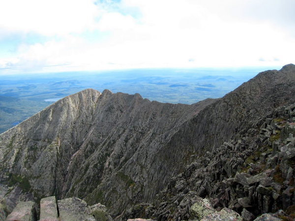
The peak affords spectacular views in all directions, but most precipitously to the north, east and south. To the north the cliffs fall precipitiously into the cirque that contains Chimney Pond and the forested land beyond. To the east you are treated to the verticality of the sharp ridge known as the Knife Edge that begins to the northeast at the peak known as Pamola and sweeps out a precipitious arc on its way to Baxter Peak (passing South Peak on the way). There is a rough but dangerous hiking (climbing?) route along the Knife Edge that should only be attempted in the best weather conditions for a stumble and fall here will be fatal. The land also falls off precipitously to the south of Baxter Peak and the lakes that so populate this terrain stretch off in the distance in this direction.
 | 
| |
|---|---|---|
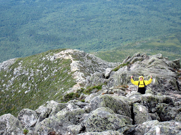
| Pamola Peak, the Knife Edge and South Peak from Baxter Peak | Looking down the Hunt Trail ridge |
Beginning the descent you proceed back along the way you came to the the trail junction at Thoreau Spring at
45o53.91'N 68o56.20'W and 4627ft elevation. You should reach this point
4.8miles and 5hrs from the morning start. Instead of returning by way of the Abol Slide, however, you can
proceed along the Appalachian or Hunt trail (following the white blazes), heading for the Katahdin Stream Campground and
Trailhead. The first section of this trail beyond Thoreau Spring is deceiving; it is flat and easy across the plateau with
good views from the top of the cliffs to the south or left. However, 0.5mile from Thoreau Spring you abruptly come to
the point where the trail drops off the side of the plateau at 45o54.00'N 68o56.84'W,
4577ft elevation and 5.3miles from the start. From there, the trail descends along the apex of a steep and rocky
ridge with a number of downclimbs. About 3720ft elevation, the steepness of the ridge decreases and the going
correspondingly eases. Gradually you enter the forest and eventually, about 8hrs and 7.9miles from the start
at 45o53.77'N 68o58.90'W and an elevation of 1650ft the trail closes in on Katahdin
Stream and you get a great view of the beautiful Katahdin Stream Falls that cascade down over a series of rocky steps. Just below the falls
the trail crosses the stream via a wooden bridge. Thereafter the trail is fairly level and the going over the last mile
through the forest is easy. About 1.1mile from the bridge you finally reach the Katahdin Stream Campground and Trailhead
at 45o53.24'N 68o59.93'W and an elevation of 1080ft. If this is the end of your hike then
you will have hiked 9.0miles in about 9.5hrs. However, if you not arranged a car shuttle then you will need to
hike back along the Tote Road to the Abol Trailhead, a distance of 2.2 miles.
Last updated 11/20/03.
Christopher E. Brennen