ADVENTURE HIKES AND CANYONEERING
IN THE SOUTHWEST
© Christopher Earls Brennen

|
|---|

|
Hike F6. Icecube Canyon, The Maze
- Hiking time: 12 hours
- Estimated hiking distance: 4.3 miles
- Elevation gain: 670 feet
- USGS Topo Map: La Madre Spring
- Difficulties: A strenuous and technically demanding canyon, with advanced slot canyon challenges, 20 rappels including a final 190ft descent, and much swimming
- Special equipment: Rapelling gear including harnesses and helmets, two 200ft ropes, 200ft recovery cord, 200ft webbing, 20 rappel rings, a few pitons with hammer, drybags, wetsuits

Characteristics
The Red Rock Canyon National Conservation Area just 13mi west of Las Vegas, Nevada, is a spectacular maze of dramatic red and white canyons, all sliced into the eastern edge of a great sandstone escarpment. The scenery is fantastic, a vertical world of stark and sheer slickrock with huge drop-offs in every direction. Within this park are many marvellous adventure hikes, four of which are included in this collection, In one we describe a hike to the highest peak in the Red Rocks, the 7003ft Bridge Mountain; it is a beautiful day hike that could be undertaken at any time of the year when there is no substantial snow lying on the slickrock. Two others describe descents of Hidden Falls Canyon (also known as Lost Creek Canyon) and the awesome Icebox Canyon, an adventure that culminates in a spectacular final rappel. Here, however, we describe perhaps the most technically demanding canyoneering descent in this whole collection, namely the journey down the canyon just to the south of Icebox, between Icebox and Bridge Mountain. The canyon is unlabelled on the topo map; the area through which it descends is known by local climbers as "The Maze"; we called the canyon Icecube. It is so challenging that it should not be undertaken except by experienced canyoneers.
The first section of the adventure is the most technically challenging. It is the passage through the narrow slot of upper Icecube during which one must accomplish about 8 successive rappels down a narrow slot with few natural anchors while trying to stay out of the slot-filling pools of water. The very slippery rock under the waterline adds significantly to the challenge. Here you really need a wet suit (except, perhaps, when the temperature up above the slot is greater than 100 degrees) for it can get quite cold down in the dark cold water of the slot.
The second section is a relaxing stroll down the boulder-strewn streambed in the bottom of a beautiful tree-lined canyon with sculpted red rocks on all sides. The third section is a long series of rappels as the canyon falls quickly toward its exit. This section has many large pools and several swimming disconnects. Except for the last, none of the rappels is over 100ft but finding good anchors is hard in some places. Like the first section this part can be quite cold. The final rappel, the climax, is a truly awesome 190ft descent that begins in a narrow slot and opens up into a substantial free rappel. It is a fitting end to this fantastic adventure.
Because the Icecube descent takes at least 12hrs it should be done in summer with a very early start. The cold in the first and third sections is such that the adventure is best undertaken in summer when the temperatures overhead are in the 90s or 100s. Such heat may mean that the second section is excessively hot but that seems the best overall choice.
Trailhead
This adventure requires a shuttle using two 4WD vehicles. The trailhead is at Red Rock Summit (36o7.85'N 115o32.00'W and an elevation of 6450ft), a pass traversed by a rough 4WD dirt road. The approach is from the northeast. Drive about 13mi west from Las Vegas along Charleston Boulevard (Highway 159) to the entrance of the Scenic Loop through the Red Rock Canyon National Conservation Area. (Or you can drive north from the Blue Diamond/Pahrump exit on Interstate 15 along Highway 160 and turn north on Highway 159 to the Scenic Loop entrance). The Scenic Loop opens at 6.00am and the entrance fee is $5.
From the entrance follow the one-way Scenic Loop for 7.5mi to where a short spur forks off to the right to Willow Springs Picnic Area. Continue on down the left fork to the Icebox Canyon Trailhead (36o9.04'N 115o28.84'W and an elevation of 4340ft) where you should leave the recovery vehicle. Then, with all the participants and their gear loaded into the ascent vehicle(s), back up the one-way road to the Willow Springs spur and continue up to Willow Springs (1.3mi from the Icebox Trailhead). Here the asphalt ends but you continue on up the rough 4WD dirt road, known as the Rocky Gap Road, for about 4.4mi to the obvious Red Rock Summit. Park here.
Hike
From the Red Rock Summit trailhead (elevation 6450ft), proceed east following the well-worn trail through sparse juniper forest for 0.8mi. The trail climbs to the crest of the dominant north/south ridge overlooking the canyons to the east. You should reach the ridgetop (36o7.92'N 115o31.27'W and elevation 7120ft) after about 40min. Once there, you are treated to a spectacular view of the Red Rock Canyon National Conservation Area. Take a moment to examine the terrain before you. A steep juniper-dotted slope falls off steeply below you until it meets a line of bare slickrock. Beyond that you should be able to identify Bridge Mountain. Hopefully you can also spot the neck of slickrock that you would cross before ascending the crack up the face of Bridge Mountain. Icecube Canyon defines the left side of this neck.
To access the head of Icecube Canyon follow the ridgetop trail south for about 500yds until you come to the sign where the Bridge Mountain trail forks right and a use-trail goes left. Follow the use-trail that contours briefly but soon begins to descend along a lateral ridge. The trail ends at the slickrock at the head of a small tributary of Icecube (elevation 6770ft); you should reach this point about 50min from the start. Descend the slickrock gully but, when you come to a sizeable drop, contour left to enter the main fork of the Icecube (36o7.85'N 115o31.04'W). Descending the deepening canyon you soon come to the first rappel, at 6460ft and 1hr 30min from the trailhead. This is a simple little 12ft drop from a good trapped-rock anchor in midgully. Shortly thereafter there is a bypass of another dryfall on the left; this is followed by several downclimbs before you come upon a large boulder in mid-canyon.
 | 
| |
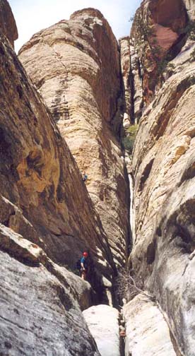
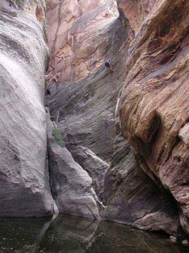
|---|---|---|
| A wide secion of the upper slot | Author descends 100ft in the last section |
Forking to the left of the boulder you come to the start of the long and challenging technical descent of upper Icecube. It begins with a simple 30ft rappel from a small tree anchor on the left side of the big boulder. This is immediately followed by a two-stage 60ft rappel from a tree on a ledge on canyon right, where you first drop down to a pool in the canyon bottom and then continue down a slot to another pool with a ledge on the right side. It is deep and dark in here. The pool is followed immediately by a series of short downclimbs and small pools until the slot opens very briefly. From here you enter the most demanding slot canyon in the Red Rocks. The canyon narrows to a deep and very narrow slot. From above, it is impossible to tell where the slot ends. First, from a bush anchor, you descend 30ft into the narrow slot to where there is a large old tree stump logjam. Set an anchor on this tree stump and continue the descent another 80ft in several stages to where the slot makes a sharp right turn. Here, at the turn, the bottom is a chest-deep pool with a very slippery underwater rock surface. These very slippery underwater surfaces are almost universal throughout the canyon and make it very difficult to get any traction underwater. At this bottom, this feature makes it almost impossible to get out of the pool. You have to stem across above water and move laterally to get to dry ground. Just beyond this point you will come to a 30ft rappel where the only anchor is a deadman in a small pool just above the lip. This drop ends in a wading pool that leads to the next obstacle. The slot narrows again and turns sharp left. However, there is a 8ft drop into a water-filled trench just before the turn. The best route here is to descend into this trench and then climb the other side up onto a broad and warm shoulder up above and to the right of the slot. From this shoulder you can bypass the next section of slot by rappelling off a tree anchor (piton placements are also possible here) and down about 120ft to dry canyon bottom. Just beyond this landing area the canyon broadens and there is a sunny spot where you can pause to warm up. You should reach this resting area about 4hr after the morning start.
At this point where the canyon broadens there is a sloping ledge on the right where you can climb out up to the Bridge Mountain trail that runs along the ridge above you on the right. By this means you could return to the trailhead and thus complete a technically challenging half day adventure. The route is around to the left of a large rock mass with some exposure though you can also chimney up a short, wide crack to the right of the rock mass and thus avoid the exposure. You then keep going right to meet the Bridge Mountain route marked by cairns and two black stripes of paint.
Resuming the canyon descent beyond this escape point, there are two short 20ft rappels followed by a shallow slot that leads to a deep pool, the first of many swims in this day. Set up an anchor around the chockstone at the head of this slot so you can rappel through the next two pools. Then descend into and swim across the first pool. The main difficulty here is in exiting the pool because of the slippery underwater rock surface. This first pool is followed by another short slot and another swimming pool that is again difficult to exit. Finally this long upper section of Icecube comes to an end and the canyon opens up into a broad valley right under Bridge Mountain and the Bridge Mountain neck. You should emerge from the upper Icecube slot at 36o7.93'N 115o30.46'W and an elevation of 5900ft about 5hrs from the morning start.
The Jekyll and Hyde character of Icecube now mainfests itself for the next 0.7mi or so is a very pleasant walk down a boulder-strewn streambed (usually dry) with many beautiful trees and high rock sculptures on both sides. Just after exiting the upper slot, the canyon turns northeast and proceeds in this direction for about 0.5mi. There are many nice spots for a lunch break. You will also find a number of cairns whose purpose is unclear but which show that there are other easier ways to access this central section.
The tranquil central section begins to turn east and steepen at 5500ft and 1hr from the end of the upper slot. Flowing water reappears and some downclimbing becomes necessary. Then, quite abruptly at 5350ft and just under 7hrs from the start you come to the start of the third, technical section of Icecube Canyon. This begins with an attractive, open 70ft vertical rappel from a bush anchor next to the right wall of the canyon. Veer right as you descend to avoid the deep pool at the bottom of this rappel; instead access the shelf on the right. Just beyond this is a rock gate opening out to an attractive triple canyon junction. Here, the main canyon turns left. The next rappel is just downstream and consists of an awesome 100ft vertical drop into a wading pool that is surrounded on three sides by magnificent vertical walls. This rappel uses a good boulder anchor a short distance upstream. It has a very awkward small pool right at the lip that makes the entry particularly difficult because the underwater surface in the pool is so slippery. You should reach this point (elevation 5150ft) about 8hrs from the start.
From here on the rappels have only short distances between them. The next is an awkward 20ft drop from a group of chockstones with overhang. It descends to a horizontal water-filled slot that you can traverse by stemming. This leads to a wider pool that can be partly bypassed on the left by a submerged ledge; but this is followed by a waist-deep wade. At the end of this slot the stream turns sharp left through a gate and drops 30ft. A small tree high up in the end of the slot provides an anchor for this drop. Just downstream is an easy downclimb (on the right) of a 20ft waterfall. A little further along there is a short 12ft rappel (from a small tree anchor) down a slot next to the right wall. This is followed by a 25ft rappel (from a tree anchor) that drops you into a deep and dark water-filled slot. For the first horizontal 20ft or so, you can avoid the water by using a ledge on the left. Thereafter you may be able to continue to stay out of the water by stemming at least the next 20ft. But most hikers will end up swimming the last part where the slot widens and turns left. There you can climb out onto dry land.
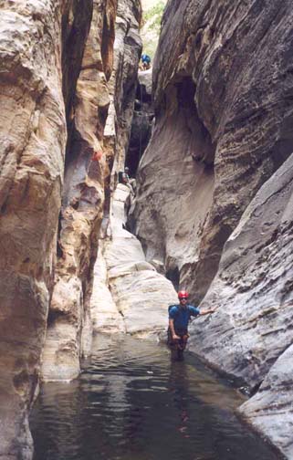 | 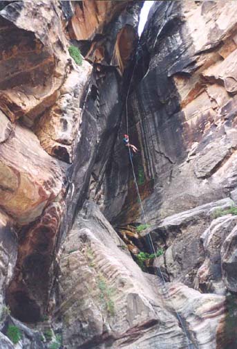
| |
|---|---|---|
| In the third section | Mark on the 190ft rappel |
A short way downstream there is another short 20ft rappel through a gate at a canyon right turn. This uses a small bush anchor on canyon left. This rappel drops into a swimming pool from which the exit is made difficult by a very slippery bedrock bottom. The first person down may be able to aid the rest to surmount this bedrock by pulling on the end of the rope. Just a few steps further on you must swim through a short deep pool that, for once, has a relatively easy exit. A stretch of bouldering follows where, in late spring, there are some big bushes with beautiful violet flowers. The next obstacle is a rappel into a deep swimming pool with a huge boulder sitting over the upstream end. Using a small tree anchor, rappel through the slot to the right of the big boulder and descend to the pool where a swimming disconnect is required. Just downstream you come to the penultimate rappel, a 30ft drop over a huge boulder and down into a narrow slot. We used a deadman anchor here though there are also large boulders you could wrap. The slot at the bottom contains some water that is easily avoided using the ledge on the left.
Here you have finally arrived at the top of the last rappel (36o8.54'N 115o29.50'W), an awesome descent of 190ft, much of which is free rappel. From the landing point of the previous rappel, it is just 30ft along the narrow horizontal slot (about 2ft wide but narrower at foot level) to the chockstones in the slot bottom that provide a principal anchor for the last rappel. We set a webbing wrap around the chockstones but also set a nut in a crack about 10ft above the chockstones; this allowed us too rig the rappel ring just above the level of the chockstones thereby providing easier entry to the rappel and a much easier rope recovery. The first section of this final rappel is a challenge because it is very narrow and not easy to squeeze through. There is a secure footing, a secondary slot floor, about 15ft below the chockstones where the slot widens. You could have someone lower your pack to you once you have descended that far. Alternatively you could suspend your pack below you from your harness. Once that first section is completed, you move to the end of this second slot floor to where the continuation of the descent is vertical with long sections of overhang. This is a spectacular rappel during which you seem to float out from the narrow slot into a vertical, moss-strewn abyss. At the bottom you must swim or wade across an awkward pool to access the shelf on the canyon right. You should come to this point (elevation 4750ft) about 11hrs 30min after the morning start.
When you are all gathered, contour right on the sloping shelf to find an easy descent down a shallow slot to the boulder field. The final leg is the descent of a long boulder-strewn gully where the best route seems to lie on the right side. This descent brings you to the main wash emerging from Icebox Canyon. Climb out the other side of the wash to join the trail that leads up into Icebox Canyon. Descend this trail for 0.8mi to the Icebox trailhead (36o9.04'N 115o28.84'W and elevation 4340ft) and your recovery vehicle.
The descent will take about 12hrs and is just possible during daylight
in the summer. The park rangers will ticket vehicles remaining in the parking
areas after 8.00pm so this also constrains the timing of the hike.
It is almost inevitable that the drive up to recover the trailhead vehicle
and the subsequent descent will have to be completed in the dark.
Last updated 23/5/03.
Christopher E. Brennen