ADVENTURE HIKES AND CANYONEERING
IN THE SOUTHWEST
© Christopher Earls Brennen

|
|---|

|
Hike F5. Icebox Canyon, Red Rocks
- Hiking time: 11 hours
- Estimated hiking distance: 3.6 miles
- Elevation gain: 670 feet
- USGS Topo Map: La Madre Spring
- Difficulties: 9 rappels including one 200ft mostly free rappel requiring a pool swim at the top, perhaps 3 or 4 additional pool swims, much bouldering and downclimbing
- Special equipment: Rappeling equipment, 60 meter rope, 60 meter recovery cord, 150ft webbing, 9 rappel rings, harnesses, helmets, wetsuits with bootees and gloves, dry bags
-
ACA Rating: 4B IV

Characteristics
The Red Rock Canyon National Conservation Area just 13mi west of Las Vegas, Nevada, is a spectacular maze of dramatic red and white canyons, all sliced into the eastern edge of a great sandstone escarpment. The scenery is fantastic, a vertical world of stark and sheer slickrock with huge drop-offs in every direction. And in the deep canyons and gorges, there are countless waterfalls, most of which are dry during the summer months when the sun bakes the desert all around. In contrast, the winter brings snow to the high ground adding yet another hue to this wonderland. The falls and pools often freeze over making progress more difficult. But, during the fall or spring, this is a spectacular natural playground that is surprisingly little known beyond a group of local hikers and climbers.
This collection of adventures includes three hikes in the Red Rocks. In one we describe a hike to the highest peak in the Red Rocks, the 7003ft Bridge Mountain; it is a beautiful day hike that could be undertaken at any time of the year when there is no substantial snow lying on the slickrock. In another, we describe a descent of Hidden Falls Canyon (also known as Lost Creek Canyon), a moderate canyoneering adventure that can be completed comfortably in a day without getting more than your feet wet. In contrast, the third adventure, this descent of Icebox Canyon is a very demanding canyoneering experience down one of the most spectacular canyons anywhere in the Southwest. It ends with an awesome 200ft mostly free rappel with a swim on rappel through a deep pool just upstream of the lip of the big drop. The free rappel descends through the huge "Icebox" undercut into the sandstone cliff. Some day before the hike, it would be wise to hike up to this point from below in order to understand the geometry of the place. This would also allow you to plot your downclimb past the pools and falls below the big drop.
The length of this hike and the swimming obstacle at the end make this an adventure that is best undertaken in late spring or early fall. In the high summer the heat may be excessive.
Trailhead
This adventure requires a shuttle using two 4WD vehicles. The trailhead is at Red Rock Summit, a 6450ft pass at 36o7.85'N 115o32.00'W traversed by a rough 4WD dirt road. The approach is from the northeast. Drive about 13mi west from Las Vegas along Charleston Boulevard (Highway 159) to the entrance of the Scenic Loop through the Red Rock Canyon National Conservation Area. (Or you can drive north from the Blue Diamond/Pahrump exit on Interstate 15 along Highway 160 and turn north on Highway 159 to the Scenic Loop entrance). The Scenic Loop opens at 6.00am and the entrance fee is $5.
From the entrance follow the one-way Scenic Loop for 7.5mi to where a short spur forks off to the right to Willow Springs Picnic Area. Continue on down the left fork to the Icebox Canyon Trailhead (36o9.04'N 115o28.84'W and an elevation of 4300ft) where you should leave the recovery vehicle. Then, with all the participants and their gear loaded into the ascent vehicle(s), back up the one-way road to the Willow Springs spur and continue up to Willow Springs (1.3mi from the Icebox Trailhead). Here the asphalt ends but you continue on up the rough 4WD dirt road, known as the Rocky Gap Road, for about 4.4mi to the obvious Red Rock Summit. Park here.
Hike
From the Red Rock Summit trailhead (36o7.85'N 115o32.00'W and elevation 6450ft), proceed east following the well-worn trail through sparse juniper forest for 0.9mi. The trail climbs quite steeply to the crest of the dominant north/south ridge overlooking the canyons to the east. You should reach the ridgetop (36o7.92'N 115o31.27'W and elevation 7120ft) after about 50min. Once there, you are treated to a spectacular view of the Red Rock Canyon National Conservation Area, a slickrock maze of interlocking canyons. Rising above these, its white rock striking in the morning sun, is the great block of Bridge Mountain, the subject of another adventure.
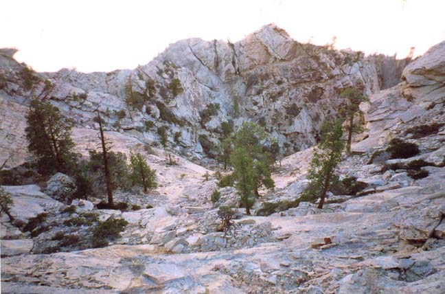 | 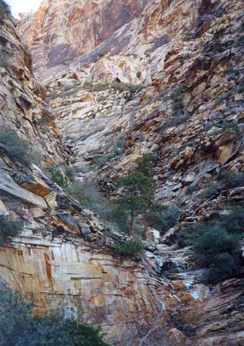
| |
|---|---|---|
| View down into Icebox Bowl | Upper Icebox Canyon |
At the ridgetop, the maintained trail goes right, but you turn left and follow a use-trail along the crest for about 300yds, around a rocky promontory to an overlook where you are treated to a spectacular view of the huge bowl at the top of Icebox Canyon. Beginning about 400ft below you, the Icebox bowl funnels down into a deep canyon which then flows down to the desert about a mile and a half away. It is unmistakable. From this vantage point on the ridge (36o8.09'N 115o31.09'W) you descend for about 400yds down an easy earth slope through small juniper trees heading directly for the bare slickrock on the right side of the bowl. You should reach the edge of the bowl (36o8.11'N 115o30.80'W and elevation 6790ft) about 1.3mi or 1hr 20min from the start.
The descent into the steep-sided bowl requires multiple rappels; it is important to plan ahead, plotting your future rappel anchors as far in advance as you can. Then drop into the bowl where you can spot the easiest downclimbing route. Downclimb (or rappel) the steep side over broken rock and ledges. About 120ft below the rim, veer to the left for about 50yds to find the best descent route down to a group of pine trees about 250ft below the rim. Here you should discern a route straight down the bowl to its focus, rappelling from one large tree on a ledge to another. The rappels are down sloping slickrock that can, in places, be coated with ice during the winter months. From a large tree anchor, the first rappel slopes down about 100ft to a broad ledge with a single large tree. From there the second rappel descends a further 130ft to another single tree on a broad ledge. Here you are treated to a truly awesome view down into Icebox Canyon. You should reach this point about 3hr 45min from the morning start.
A short traverse to the left brings you to the streambed and you begin a section of downclimbing in which several detours into the brush on the left of the gully make for the eaiest descent. A little below the detour you climb down into a bedrock channel where, at an elevation of 6300ft there are two rappels, a 60ft drop from a boulder anchor on the right side of the streambed and then a short 20ft descent from a webbing anchor under a large chockstone in the center of the streambed. More downclimbing in a steep canyon stream course follows. About 6hr from the trailhead you come to the first of two class 4 downclimbs, a tricky 30ft descent on the left side of the canyon. This is followed shortly thereafter by a similar 35ft downclimb also on the left wall. And just a little later at an elevation of 5590ft you arrive at a 50ft drop into a large round pool about knee-deep. The anchor is a large tree on a shelf to the right where you rappel down onto a ledge just above the water level. From there you can just avoid wading in the water by climbing along small ledges on the right side of the pool.
This is a particularly beautiful section of the canyon where the stream wanders down lovely sculpted and scoured sandstone bedrock. More downclimbing follows, and at 5400ft and 7hr 40min from the start there is a 20ft rappel around a large canyon blocking chockstone with much overhang; a streambed boulder can be wrapped as the anchor.
You are now approaching the last and most challenging part of Icebox Canyon. At an elevation of 4990ft and 8.5hrs into the hike you will come to a 40ft two stage waterfall, a small but deep hanging pool about 10ft below the lip followed by a 30ft drop into a waist-deep pool. Before beginning this rappel, it is a good idea to change into the wetsuit or other garments in which you intend to swim when you get to the big drop. Then descend using a tree high on the left as the anchor. A little further downcanyon is the first place where swimming may be neccessary; a 10ft slot that can be chimneyed leads to a 10yd swim.
Just below this at 36o8.58'N 115o29.99'W and an elevation of 4920ft you finally arrive (9hrs and 2.3mi from the morning start) at the top of the crux rappel in Icebox Canyon. It will be first recognized by the very large dead tree propped up against the right-hand wall of the canyon about 30ft from the top of the slot at the start of the descent. If the tree is still there, a webbing wrap around it provides the anchor for the rappel. You need at least 200ft of rope to make a safe descent in daylight. Set up a single strand rappel with a 60m rope and a 200ft recovery cord. The descent then consists of rappelling down a steep 15ft slot into a deep pool and swimming 10yds across the pool while still on rappel to a smooth lip at the far end of the pool. The lip is broad enough to allow you to stand and feed the rope and recovery cord over the edge and down into the abyss below. Do this carefully to avoid tangles. The 160ft vertical descent from here is mostly a free descent down across the face of a huge cave (the "Icebox") where there is a massive undercut in the sandstone. It is a spectacular rappel experience. If the stream is flowing you will also be drenched from above as you descend. At the bottom you land on some steep and wet rock steps just above a large deep pool that is about 10yds long.
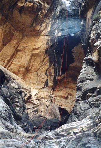 | 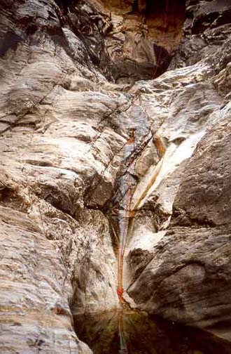
| |
|---|---|---|
| The big rappel | Below the big rappel |
The next part of the descent is fairly easy in daylight. Going off-rappel you can bypass the first pool using a series of small ledges on the right side near the water's edge. This leads to a lip at the top of a 10ft drop into a small waist-deep pool about 5yds across. Cross over to the left side to bypass this second pool. This takes you to the top of a 50ft sloping drop into a shin-deep wading pool. Cross over again to the right and use a broad sloping bench to descend this 50ftdrop. It should be noted that this series of obstacles after the big rappel is difficult to negotiate in darkness and, given the length of this hike, there is a possibility that you will arrive here after dark. It is then very valuable to have reconnoitred this part of the canyon from below. Moreover, if you carried a 340ft rope and recovery cord rather than the 200ft lengths it would be wise to continue the rappel down these obstacles below the big drop.
At this point you can remove your harness and stow the ropes since there
are no more technical obstacles. This is a location that many people hike
up to from below. It is also a canyon junction for a large tributary
enters on the left, a canyon known as Buffalo Wall Canyon. Below this
junction there is a 10ft drop into a waist-deep pool but it is
readily bypassed using a broad ledge on the right. From there follow
the streambed or the use-trail around boulders and pools until you
spot a sign where, for easier passage, the maintained trail climbs up the
bank on the left side of the canyon. The trail then exits the canyon
and continues across a wash to the Icebox Trailhead
(36o9.04'N 115o28.84'W and
elevation 4300ft). It takes 1hr to
hike the 1.3mi from the bottom of the big rappel to the trailhead.
The total hike length of 3.6mi will take about 11hrs to
complete.
Last updated 4/1/02.
Christopher E. Brennen