ADVENTURE HIKES AND CANYONEERING
IN THE SOUTHWEST
© Christopher Earls Brennen

|
|---|

|
Hike F4. Hidden Falls Canyon, Red Rocks
- Hiking time: 7 hours 20 minutes
- Estimated hiking distance: 2.5 miles
- Elevation gain: 1240 feet
- USGS Topo Map: La Madre Spring
- Difficulties: Seven rappels up to 110ft, much bouldering and downclimbing
- Special equipment: Rappeling equipment, 60 meter rope, 50 feet webbing, 7 rappel rings. 130 feet recovery cord, harnesses and helmets
-
ACA Rating: 3A III

Characteristics
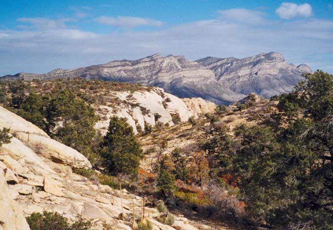
The Red Rock Canyon National Conservation Area just 13mi west of Las Vegas, Nevada, is a spectacular maze of dramatic red and white canyons, all sliced into the eastern edge of a great sandstone escarpment. The scenery is fantastic, a vertical world of stark and sheer slickrock with huge drop-offs in every direction. And in the deep canyons and gorges, there are countless waterfalls, most of which are dry during the summer months when the sun bakes the desert all around. In contrast, the winter brings snow to the high ground adding yet another hue to this wonderland. The falls and pools often freeze over making progress more difficult. But, during the fall or spring, this is a spectacular natural playground that is surprisingly little known beyond a group of local hikers and climbers.
This collection of adventures includes three hikes in the Red Rocks. In one we describe a hike to the highest peak in the Red Rocks, the 7003ft Bridge Mountain; it is a beautiful day hike that could be undertaken at any time of the year when there is no substantial snow lying on the slickrock. In another, we describe a descent of Icebox Canyon, a very demanding canyoneering adventure down one of the most spectacular canyons anywhere in the Southwest. Here we describe a more modest, but still challenging descent of Hidden Falls Canyon (also known as Lost Creek Canyon). The hike can be completed comfortably in a day. There are about 7 rappels, one of 110ft, one of 90ft and some smaller ones. Unless there are substantial changes in the canyon it is not neccessary to get wet, except perhaps to wade in shin-deep water in one narrows near the bottom.
Trailhead
This adventure requires a shuttle using two 4WD vehicles. Drive about 13mi west from Las Vegas along Charleston Boulevard (Highway 159) to the entrance of the Scenic Loop through the Red Rock Canyon National Conservation Area. (Or you can drive north from the Blue Diamond/Pahrump exit on Interstate 15 along Highway 160 and turn north on Highway 159 to the Scenic Loop entrance). The Scenic Loop opens at 6.00am and the entrance fee is $5. From the entrance follow the one-way Scenic Loop for 7.5mi to where a short two-way spur forks off to the right toward the Willow Springs Picnic Area. Just 0.5mi up this spur road you will come to the Lost Creek Trailhead (elevation 4460ft). Park the recovery vehicle here (36o9.49'N 115o29.68'W). Then, with all the participants and their gear loaded into the ascent vehicle(s), continue on the asphalt road for 0.3mi to Willow Springs where the asphalt ends. Then proceed up the rough 4WD dirt road beyond the end of the asphalt (the road is called the Rocky Gap Road). About 2.3mi beyond Willow Springs you will come to a place where the road drops about 6ft to cross a wash coming down from the right. Park in the flat wash to the right where you can turn the vehicle (36o9.07'N 115o31.40'W and elevation 5500ft).
Hike
The trail (starting elevation 5500ft) starts in the lateral wash on the opposite side of the road (southeast side) and is well marked by a cairn and by trailside rocks. After crossing the main wash it climbs to the apex of a lateral ridge coming down from high crest and ascends this all the way up to that crest, 1240ft above the trailhead. Near the top the trail proceeds over broken slickrock but is well marked by cairns. The 0.9mi climb to the 6740ft crest should take about 1hr 30min.
|
|---|
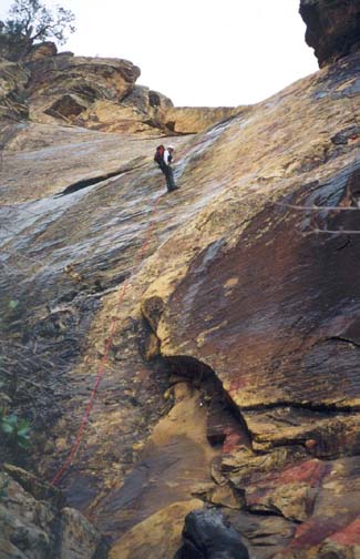
| Drop-in to Hidden Falls Canyon |
The view east from the ridgetop (36o8.71'N 115o30.83'W) is marvellous and you should take a moment to enjoy it before following the cairns to the left for about 50yds. They lead to a shallow draw heading off in a northeast direction, the beginning of Hidden Falls Canyon (36o8.79'N 115o30.79'W). The draw drops slowly for the first few hundred yards until you arrive at the first rappel at about 6550ft, a modest 25ft drop using a small tree on the left as the anchor. Then continue in a deepening gully, past some friction downclimbing to an elevation of about 6300ft where you arrive at the second and highest rappel in this canyon. This is a 110ft sloping cliff where a larger canyon comes in on the right. The anchor is a stout tree on the left. You should reach this point about 2hrs 40min from the morning start.
 | 
| |
|---|---|---|
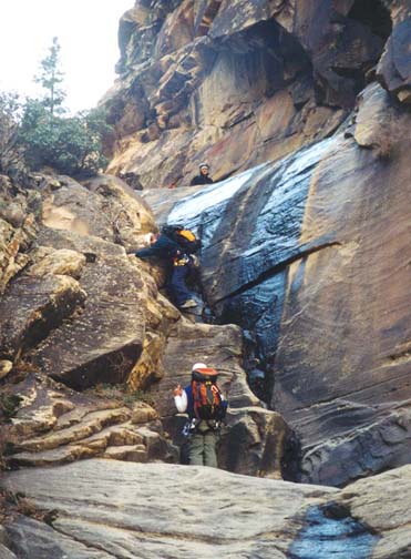
| Second rappel in Hidden Falls | Downclimbing in Hidden Falls |
There follows a long section of modest downclimbing and bouldering; the canyon gradually narrows and the walls rise high above you on both sides. Then, just after a place where you climb down a slot on the left side while the streamcourse is by the right wall, you will arrive at the readily recognizable junction with the Left Fork coming in on your right. This junction is at 5470ft and you should reach here about 4hr after the morning start. It is a good place to take a break and prepare for more challenging terrain ahead.
|
|---|
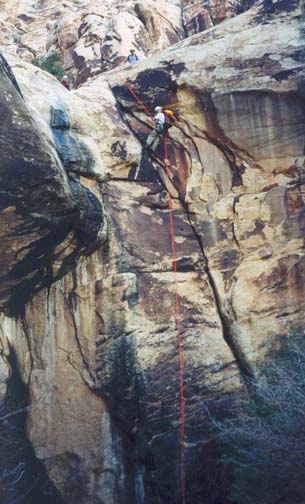
| Last rappel in Hidden Falls |
Downstream of the Left Fork junction, the stream course drops more rapidly in a narrower canyon. Here the water has scoured the canyon to the bedrock and has created a section with much class 3 downclimbing. One class 4 downclimb at the bottom of a steep sloping rock, looks more difficult than it is though most people will want a belay line here. The route goes down steep steps just to the right of the stream. Much downclimbing and bouldering follows; in one spot at 5050ft a small 12ft rappel on the left side of a large canyon-blocking boulder can be avoided by climbing down through a hole under the boulder on the right side. The spot is recognizable by the Mettalica graffiti painted on the rock to indicate the location of the hole.
Then at 4810ft and 5hr 20min from the trailhead, you will come to the first of a series of rappels interspersed with downclimbs at the end of Hidden Falls Canyon. The first rappel (currently anchored by a webbing wrap around a large log) is a simple 25ft drop down an abrupt step into a pool that you may have to wade unless you adroitly cling to the rock on the right side of the pool. Just downstream is another abrupt 35ft drop; here a high shelf on the left, if followed around a corner, will lead to dubious piton anchor that needs to be replaced. From here you rappel down 40ft to the streamside. A very similar manouver follows. Again climb to the left over slickrock and descend into a shallow groove where there is a small tree anchor for a 40ft rappel down into the streambed.
The last rappel is just about 100yds downstream and can, reportedly, be bypassed by climbing over the bluff on the left. You should reach the top of this last rappel (36o9.36'N 115o29.89'W and elevation 4660ft) about 7hrs after leaving the trailhead. This last descent is a 90ft vertical drop into a nice desert grotto; the anchor is a webbing wrap around a large boulder in the streambed.
From the bottom of this last rappel, a well-maintained trail leads back to
the road at the Lost Creek Trailhead
(36o9.49'N 115o29.68'W and
elevation 4470ft) where you
left the recovery vehicle. The complete hike covers a total of 2.5mi
and should take about 7hr 20min.
Last updated 12/20/02.
Christopher E. Brennen