ADVENTURE HIKES AND CANYONEERING
IN THE SOUTHWEST
© Christopher Earls Brennen

|
|---|

|
Hike A1. Havasu Canyon
- Hiking time: 3 days
- Estimated hiking distance: 22 to 34 miles
- Elevation gain: 2710 to 3450 feet
- Map: Grand Canyon Hiking Map
- Difficulties: Heat in the summer
- Special equipment: Water filter
-
ACA Rating: 1A VI

Characteristics
One of the most interesting and spectacular adventure hikes in the Grand Canyon is the classic descent through the Havasupai Indian Reservation to the tribal village of Supai and the beautiful blue-green river and waterfalls beyond. The hike begins where the road ends, at a parking area on the rim of the canyon called Hualapai Hilltop. From there the hike descends 8mi to the village; the first stage is a steep, switchbacking descent into the bottom of Hualapai Canyon, followed by a dry and dusty but more gentle descent along the Hualapai Canyon wash. Just before the village, you join Havasu Canyon. The lovely river that flows in that canyon has created a verdant and riparian canyon bottom in sharp contrast to the earlier trail setting. From here on to the Colorado River, Havasu Canyon is beautiful, its sculpted red sandstone walls contrasting with the greenery in the canyon bottom and the blue-green waters of the lovely river that flows through it. Just beyond the village there are some of the loveliest waterfalls to be found anywhere in the world and the hike is worth it just for the opportunity to experience Navaho Falls, Havasu Falls, Mooney Falls and Beaver Falls.
But this hike has other marvellous facets for it provides a window into the proud and surviving culture of the Havasupai, the ``people of the blue-green waters''. The village of Supai is home to about 450, the majority of the Havasupai people. They have lived in the Grand Canyon for many hundreds of years and the isolated community of Supai remains the center of their world. In ancient times during the spring and summer they would live in the canyon where they would tend to their gardens. In fall and winter they would move up to the plateau for hunting and gathering. When the US government created the Havasupai Indian Reservation in 1882, it confined the tribe to a tiny area around the village denying them their range lands on the plateau. Fortunately this was corrected in 1975 when Congress returned nearly two hundred thousand acres to the tribe forming the current Havasupai Indian Reservation. The Havasupai are also proud of their native tongue that was transcribed to written form about 1980.
The village of Supai is situated where Havasu Canyon briefly broadens and allows extensive farming. But the red walls of Supai Sandstone still tower over the village providing security and shelter. Two columns that protrude above the western wall are called Wii'igliva and are considered male and female figures that protect the Havasupai people. The village itself is unique in the United States, being isolated and therefore insulated from the outside world. There are no motor vehicles, no gasoline fumes, no asphalt roads and very little concrete. The pace of life is gentle and rural; horses and dogs are everywhere. The wooden homes are spread out over the available land, individual plots being defined by trees and wooden and barbed wire fences. There are two small stores, a school, a church, a post office and a health clinic. Off to one side is a lodge for tourists though it is usually booked up for months ahead. One has the impression of a proud people who have had some success in maintaining their culture and way of life by partially isolating themselves from the outside world.
Trailhead
From a junction on historic route US66 about 7mi east of Peach Springs, Arizona turn onto Indian State Secondary Road 18 and drive 62mi northeast to the end of the road at the Hualapai Hilltop parking area (36o9.59'N 112o42.58'W). Note that there are no services anywhere along this road. It is however a good road across the mesa-top flatlands of the Havasupai Indian Reservation. Watch for the open range cattle and for the antelope that frequent these grasslands. Near the end the road drops down a little way before coming to the top of a shear 1000ft cliff, the upper rim of the Grand Canyon of the Colorado. Park here in the Hualapai Hilltop amidst the horses of the extensive pack station and beside the small heliport.
|
|---|
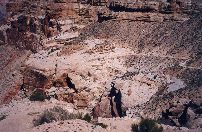
| View from Havasupai Hilltop |
Before setting off, check to ensure that you have everything you need for a three day backpacking trip. Some groceries and drinks are available in the Supai village store but you will need to bring everything else with you. Open fires are not permitted so you will need a stove if you plan to cook. The campground has a single treated water supply but few other amenities. Check the weather forecast before you set out since it may be unneccesary to bring a tent.
Hike
From the end of the parking area (36o9.59'N 112o42.58'W and elevation 5200ft) the trail drops dramatically down the Coconino sandstone precipice via a series of switchbacks cut into the cliff. After just 1mi it has descended 1000ft to the dry wash in the bottom of Hualapai Canyon. For the next 5.5mi the trail follows the gently sloping wash as the canyon drops down through the red layers of Supai sandstone. Several times you may hear the percussive sound of approaching hoofbeats from the pack mule teams galloping downhill or trudging uphill. Then it is time to stand to the side and let them past. As the scultped red walls grow the shade available increases, providing some comfortable rest stops under the overhangs. Near the end of Hualapai Canyon there are some small springs. Shortly thereafter at 3250ft, 6.5mi and 2hr 20min from the hilltop, you come to the end of Hualapai Canyon at its junction with Havasu Canyon. Here the nature of the canyon bottom changes for just upstream of the confluence in Havasu Canyon, a gushing river emerges from the ground at Havasu Springs. This river irrigates the canyon bottom and allows a profusion of desert plants and trees. Please note that Havasu Springs, Havasu Canyon upstream of the confluence and, indeed, all Havasupai land aside from the main trail described here is regarded as private by the Havasupai people and should not be trespassed upon.
 | 
| |
|---|---|---|
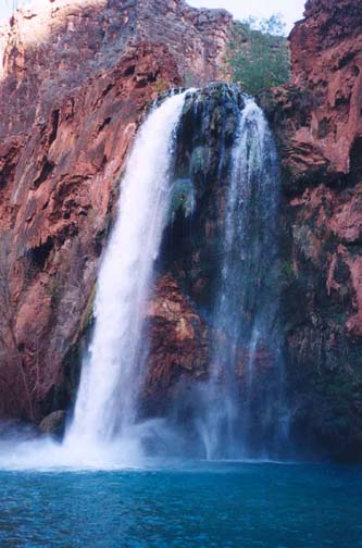
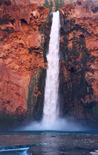
| Havasu Falls | Mooney Falls |
Turning downstream beside the river, the trail from here on is in the welcome shade of willow, tamarisk and cottonwood trees. It is just 1.5mi from the confluence to the Havasupai village of Supai (elevation 3205ft) which you should reach 3hrs and 8mi from the hilltop trailhead. In the center of the village (36o14.24'N 112o41.36'W) is a tourist office, right beside the small area that serves as the helicopter landing field. All campers must register at the tourist office ($20 entrance fee and $20 camping fee per person) where you can also get a hiking map and information on other services.
Having obtained your permit, you may then proceed on through the village following the trail as the canyon narrows again and begins to drop. Following the main path (there many braided paths) to the right of the river you will pass a place where there is a steep unstable bank with many warning signs. Here, off on the left side you will see Navaho Falls through the trees. You can get closer to those pretty falls by working your way upstream from below. Shortly thereafter there is a sign to the Havasu Campground and the trail descends to and then crosses the river by two wooden bridges. Just beyond those bridges you will arrive at the top of the spectacular Havasu Falls (36o15.31'N 112o41.90'W and elevation 3010ft) about 40min and 2mi from the village. This magnificent waterfall plunges about 100ft into a crystal blue-green pool. It is a beautiful place that alone is worth the hike down from the hilltop. The trail descends steeply to the left of the falls and there is a trail to the edge of the pool where a swim is more than welcome on a hot day.
The campground (elevation 2840ft) is just downstream of Havasu Falls and consists of many well-shaded sites (tables) stretched out along both sides of the river in a narrow part of the canyon with towering red sandstone walls. Many of the sites lie along the stream banks. However there is only one purified water faucet along the west wall of the canyon and you should be careful to use only this; though the river appears clean it is downstream of the village and is probably unsafe to drink. It takes less than 4hrs to reach the campground from Hualapai Hilltop, a distance of 10mi.
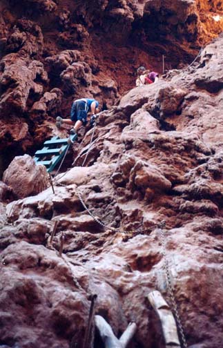
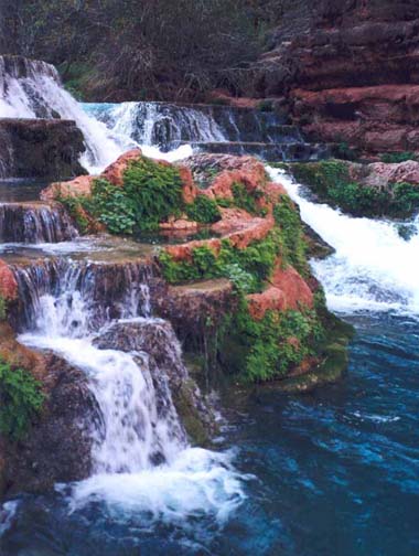
From the campground, there is a beautiful hike along the trail that continues downstream to Mooney Falls, Beaver Falls and, eventually, to the Colorado River. Decide for yourself how far you wish to go before turning around. From Havasu Falls it is 1mi through the drawn-out campground to the top of the awesome Mooney Falls, some 200ft of free-falling water plunging into another blue-green pool. The downclimb consists of several small tunnels and platforms cut from the travertine rock followed by steep steps and ladders with chains. Though straightforward, extra care must be taken when the rock is wet. At the bottom there is a marvellous view of the falls and the plunge pool.
 | 
| |
|---|---|---|
| Descending beside Mooney Falls | Beaver Falls |
From the bottom of Mooney Falls
(36o15.79'N 112o42.56'W and
elevation 2490ft, 30min
from the Havasu Campground) the trail, now less used, proceeds along
the left bank of the river and the vertical, red-walled canyon proceeds
north on its way to the Colorado River.
About 10min from Mooney Falls, you come to the first river crossing
which is usually thigh-deep or less. Just a few minutes later you cross
back to the left bank and then, just before Beaver Falls, you again cross
to the right side. A very short distance beyond this third crossing the canyon
becomes quite narrow and you
must climb a short way up onto a bluff on the right side.
On top of this bluff there are several augmented stone shelters in the
cliff at ground level, whose purpose is unclear. Beaver Falls are below this
bluff to the left but to get a good view of these smaller but very
photogenic cascades you should find a steep downclimbing route to a point
just downstream of the falls. Note that Beaver Falls
(36o16.89'N 112o43.79'W and elevation
2350ft) are 3mi and 1hr 30min downstream of
Havasu Falls (or 13mi from Hualapai Hilltop). Note also that a
large tributary, Beaver Canyon, joins Havasu Canyon just downstream of
Beaver Falls.
The author turned around at Beaver Falls
but the trail continues another 4mi to the Colorado River at the
Havasu Rapids
(36o18.47'N 112o45.79'W and
elevation 1750ft). From Beaver Falls it should take about 2hr to hike
back up to the village and another 4hr to get back up to
Hualapai Hilltop (36o9.59'N 112o42.58'W).
While it is possible to complete the hike comfortably
in two days, most people will want to take three.
Christopher E. Brennen