ADVENTURE HIKES AND CANYONEERING
IN THE SOUTHWEST
© Christopher Earls Brennen

|
|---|

|
Hike B5. Gravel Canyon
- Hiking time: 7.5 hours plus time to explore the ruins
- Estimated hiking distance: 7 miles
- Elevation gain: 960 feet
- USGS Topo Map: The Cheesebox
- Difficulties: Two rappels up to 35ft, a 30yd swim and much wading and boulder climbing
- Special equipment: Rappeling equipment, 100ft rope, 30ft webbing, 2 rappel rings, harnesses, helmets and dry bags
-
ACA Rating: 3B III

Characteristics
East and north of Lake Powell in the southeast corner of Utah, White Canyon flows through one of the most remote wildernesses in the contiguous United States. It is a land of tortured rock, crenelated and crevassed by the movement of the earth, wind and water and baked dry by the scorching summer sun. But sometimes, summer or winter, the rain comes pouring down, gathers volume as it funnels downhill and creates raging torrents that erode great gullies in the soft sandstone. Gravel Canyon is one such gorge that feeds into White Canyon just north of Highway 95. Within its length Gravel contains sections of slot canyon just a few feet wide, sometimes filled with water that require you to swim. In other places there are collections of boulders that present route finding challenges and drop-offs that must be rappelled.
This adventure descends a section of Gravel Canyon some distance upstream of the confluence with White Canyon. Known as the Middle Narrows of Gravel Canyon, it is a strenous, all-day adventure that is best undertaken in the summer when the water in the deeper slots is not too cold. However, even in the summer, there is a very real danger of flash floods that are created by sudden rainstorms and the runoff that funnels down to a torrent in these slot canyons. Do not enter the canyon if there is any sign of rain or of runoff from a recent storm.
Added attractions in this canyon are the Anasazi ruins on ledges near the point of exit from the canyon. With some climbing ability, these can be approached but you should be very careful not to damage any of these precious remains.
Trailhead
Gravel Canyon is accessed from a rough dirt road known as the Cheesebox Road that branches off Highway 95 17.5mi south of Hite and Lake Powell or 4.5mi north of the Fry Canyon Lodge. The unmarked junction (37o41.00'N 110o13.24'W) is just 200yds north of milepost 67. Note that this road can be quite rutted and so a high clearance vehicle is advisable; though it could be travelled with 2WD, a 4WD vehicle is to be preferred.
Just 100yds down this road you will come to a fork where a spur off to the left leads to the graves of two soldiers who were apparently ambushed and killed while in pursuit of some Paiutes. Continuing along the right fork, the road immediately descends into and then climbs out of the other side of White Canyon. It then follows a fairly flat bench off to the northeast, between White Canyon and a prominent redrock cliff known as Found Mesa. You drive for 12mi (45min) to where another road branches off to the right. Park at this intersection (37o42.98'N 110o3.61'W) in the middle of juniper forest.
Hike
From the intersection (37o42.98'N 110o3.61'W and elevation 6650ft) hike on up the Cheesebox road for another 0.4mi or 8min. Then leave the road at 37o43.24'N 110o3.43'W and cut left through the juniper forest. Here you will notice the cryptogramic soil that makes up most of the floor of this open forest. Treading on this soil does serious damage to the delicate communities of organisms that create this soil so, to avoid unneccessary damage, try to stay on existing beaten paths or on the patches of slickrock. Skirt to the north of some smaller drainages before starting to drop down into one of the maze of branches of a larger drainage at 37o43.34'N 110o3.62'W. If you have skirted far enough to the north then, after descending for a while, you should end up on the benches on the north or right side of the larger drainage. Here travel is easier and you will probably find use-trails. Near the bottom of the descent, the stream bed route contains several optional rappels but the route along the ledges on the right is easier and quicker. Work your way back and forth until, a little under 1hr (and 1mi) from the start, you descend to the gravel floor at a junction with a large canyon coming in on the right (37o43.36'N 110o3.91'W and elevation 6360ft).
|
|---|
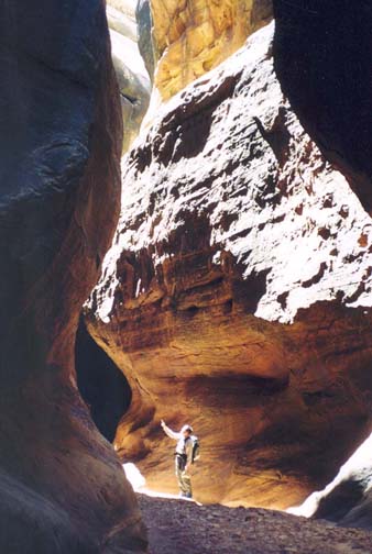
| In Gravel Canyon Narrows |
Downstream of this confluence is a beautiful section of green and open canyon with a sculptured sandstone floor. After about 10min you will come to the first substantial drop in the streambed that would require a 30ft rappel. However, the ledge on the right leads to an easy trail descent. A little further and you follow the streambed through a neat triangular "mineshaft", a passage through the boulders. Another deep slot that would require a 50ft rappel is encountered about 35min from the confluence (or 1hr 25min from the start) but, again, it is easily bypassed on the right. Just a couple of minutes later you will arrive at the confluence with the main fork of Gravel Canyon that enters on the right at 37o43.21'N 110o4.73'W and an elevation of 6080ft. You should reach this junction about 1hr 30min from the start having covered about 2mi.
 | 
| |
|---|---|---|
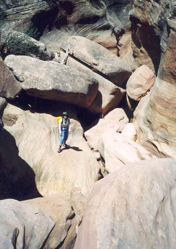
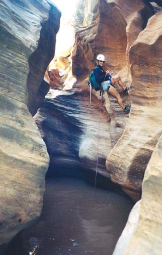
| Boulder Jam in Gravel Canyon | First rappel |
Now in the main channel of Gravel Canyon, the going gets rougher. You encounter the first serious boulder jam just 10min below the junction and a second one after another 10min. Thereafter the canyon narrows and deepens and 35min from the junction (a little over 2hr from the start) you come to a long section of 6ft wide narrows. Emerging from this, the canyon widens again and there is a stretch of open canyon where the going is easy. This ends at the first rappel which you should reach a little under 3hr from the start at an elevation of about 5800ft.
You arrive at the top of this first rappel just a short distance into a narrow slot. The floor drops about 20ft into a deep round pool. This is a good place to don your wetsuit as well as your rappelling gear. The anchor for the rappel is on the left side. Climb out of the slot onto a shelf on the left and then down through a hole between boulders to a space that opens onto the rappel. The anchor is an overhead webbing wrap that allows an easy entry to a 20ft rappel descent. However the water in the pool underneath is at least chest deep and may require a swimming disconnect and a short swim to the nearby gravel beach.
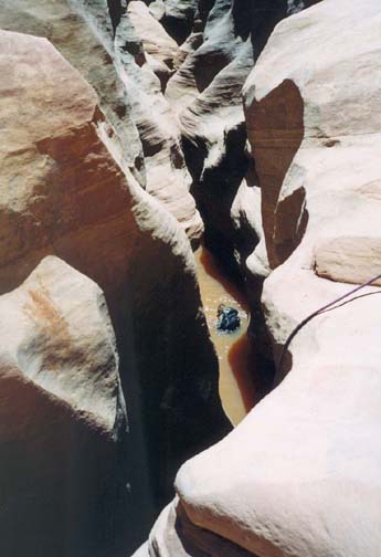
You are now deep in the Middle Narrows of Gravel Canyon and the obstacles arrive with increasing frequency. A short way down canyon from the first rappel, you must climb down about 8ft into a 2ft wide slot with 4ft deep water. Then about 40min from the first rappel you come to the second at a place where an attractive narrow canyon enters on the right. At this junction there is a deep slot in the floor of the main canyon and the second rappel descends about 35ft into the water-filled bottom of this slot. You should reach this point about 3hr 40min from the start. The anchor for the rappel is a small rock-horn in the canyon floor about 12ft to the right of the head of the slot. At the bottom of the rappel, you must do a swimming disconnect and then swim about 30yds down the slot and around a right turn. This is followed by a couple of smaller swimming pools. Just after this the canyon broadens and there is a beautiful long section with greenery and high overhanging walls on both sides. It is now time to shed your wetsuit and begin to dry out though there are still some wades to come.
You are now approaching the end of the Midddle Narrows of Gravel Canyon, having covered a little over 3mi in almost 5hr. At this point you should keep a sharp lookout for the beautiful Anazasi ruins high on the right wall (37o42.60'N 110o6.27'W). There is a particularly impressive ruin directly ahead just after the canyon makes a turn to the right. Downstream of this there are several slots with waist-deep wades before you reach the end of the canyon-bottom route. This occurs at a point where the canyon opens up and you encounter a scattered grove of about six trees with low ledges on both sides of the canyon. This grove of trees marks the end of the canyon descent; you should reach this point (37o42.26'N 110o6.62'W and elevation 5640ft) about 5.3hr (and 4mi) after the morning start. The exit route is on canyon left but you may choose to take time out here to explore the Anazasi ruins on the right side of the canyon.
 | 
| |
|---|---|---|
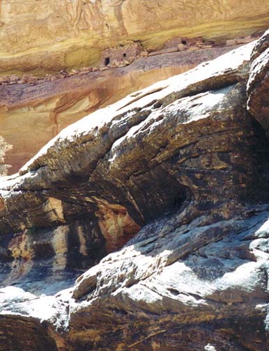
| Swimming after second rappel | Anasazi ruins from canyon floor |
Side trip to the ruins: Accessing the Anazasi ruins requires some route finding along the ledges on the canyon right as well as several places where there are significant climbing challenges. There are two sets of ruins, both some distance upstream from the grove of trees exit point. The more modest ruins (37o42.32'N 110o6.57'W) are closer and easier to access. But, if you have time, you should try to get to the second set of ruins that are further upstream at 37o42.60'N 110o6.27'W and more difficult to get to. They are better preserved and more extensive, a real thrill to see.
To get to both sets of ruins, the first step is to climb the rockfall about 30yds downstream from the first tree in the grove. This accesses a narrow ledge. Proceeding back upstream along this ledge there is a small 4ft climb with some exposure before the ledge broadens and allows easy access to the small first set of ruins about 300yds upstream. To access the more extensive ruins you must make your way a further 400yds upstream to a point on a ledge below the ruins, then continue 100yds further to where you can climb up to the ledge containing the buildings. Finally backtrack downcanyon into the ruins.
Canyon exit: The grove of trees (37o42.26'N 110o6.62'W) is also where you will begin your climb out of Gravel Canyon using ledges on left side of the canyon. Start the climb out by hiking in an upstream direction along the low, slowly rising ledge on the south side of the canyon. In places, you will be tempted to climb to higher ledges, but stay on this lowest ledge for about 600yds to where there is a large shallow gully in the side of the canyon at 37o42.50'N 110o6.21'W. Here you should have a good view of the more extensive ruins on the opposite side of the canyon. Then work your way up the side of the canyon on the north side of the shallow gully. You should reach the canyon rim about 40min from the grove of trees.
From the canyon rim it is a fairly flat, 2mi hike back through the
juniper forest to your vehicle. Hike
ENE keeping Gravel Canyon on your left and the redrock cliffs of Found Mesa
on your right. Aim for a promontory in that band of cliffs about
2mi away. Near the start you should pass well to the left of a
prominent and much closer redrock butte that is off to the ESE.
On this cross-country route, you will probably find a beaten path
through the cryptogramic soil for much of the way. Try to stay on this path
or on the patches of slickrock to avoid unneccessary damage to the
cryptogramic soil.
After 2mi you should pass close to the left of the redrock promontory
and then pass another single butte, the very northeast end of Found Mesa.
From here hike
due east for a short way to the road. It should take 2hr to hike
from the grove of trees back to the car
(37o42.98'N 110o3.61'W).
Last updated 4/1/02.
Christopher E. Brennen