ADVENTURE HIKES AND CANYONEERING
IN THE SOUTHWEST
© Christopher Earls Brennen

|
|---|

|
Hike A2. Grand Canyon
- Hiking time: 8.5 hours
- Estimated hiking distance: 16.7 miles
- Elevation gain: 4420 feet
- Map: Grand Canyon Hiking Map
- Difficulties: Large temperature differences between the rim and the river, high temperatures at the lower end of the Bright Angel Trail
- Special equipment: Extra water
-
ACA Rating: 1A III

Characteristics
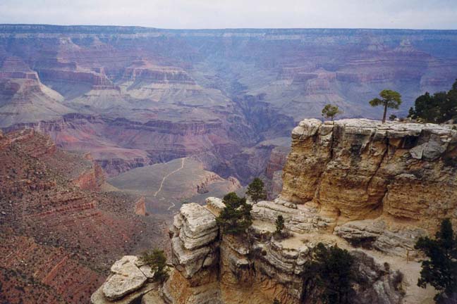
John Wesley Powell's transit of the Grand Canyon must rank as one of the greatest adventures of all time. His matter-of-fact diary is in stark contrast to the reality; perhaps inevitably for the Grand Canyon itself defies description. Powell's account also initiated the legend of the Grand Canyon that spread inevitably to all corners of the globe. Today, 130 years later, people come from all those corners to see for themselves the reality of this natural wonder. Most edge their way a short distance along the rim, both amazed and overwhelmed by the immensity of the sight before them. Their brains register tilt for nothing has prepared them for the scale of this deformity in the earth's surface. And they stay to watch the changing colors and shadows as their eyes roam across this magnificent canvas. Some even venture a short way down the few trails that descend the great cliffs below. But to see the canyon from Powell's perspective you must embark on an adventure yourself. Though paltry by Powell's standard, it is still to this day a significant achievement to be able to stand in the Colorado River and look up at the magnificent cliffs reaching into the sky all around you. To get there you must either (1) travel by boat down miles of fierce rapids (2) entrust your life to a mule and travel bumpily down trails with thousand foot drops just inches away or (3) hike the vertical mile down those same trails. In this account, the third alternative is described.
Trailhead
The base for this hike is the well-developed National Park center at the South Rim of the Grand Canyon in Arizona. There are two possible ways to schedule this hike into the canyon and back to the rim. It is quite possible to do this hike in one day provided you are very fit and provided you do not attempt it during the heat of the summer. If you do decide on this long day hike then it is not neccessary to obtain a permit. However, the preferred schedule would be to spend at least one night at the Bright Angel Campground near Phanton Ranch and this requires a reservation. To do so you should contact the Backcountry Office at the South Rim months in advance of the hike.
Hike
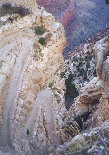
The South Kaibab Trail was constructed by the National Park Service in 1924 to compete with the privately owned Bright Angel Trail because Ralph Cameron charged a $1 toll for the latter. All the other trails down into the Canyon were located along the easiest routes and these were virtually all beside major creeks feeding the Colorado and those watercourses had eroded substantial recesses in the canyon walls. As a consequences the views from these other trails, while still spectacular, tended to be restricted by the surrounding canyon walls. On the other hand the South Kaibab Trail was specifically constructed with tourists in mind and follows an open, lateral ridgeline rather than a lateral valley. This, in itself, makes for a spectacular trail and its views are gloriously panoramic. The builders did have to build another bridge over the Colorado at the bottom of the trail and this was a major undertaking. For this bridge, eight 550 feet long, 2320 pound steel cables, 1.5in in diameter, had to be carried down the almost-completed trail. This considerable feat was accomplished by 42 Havasupai Indians each of whom therefore hefted 50 pounds of cable down 6.3mi of tortuous and precipitous trail. Thus did the cables creep down into the canyon like great, squirming centipedes.
 | 
| |
|---|---|---|
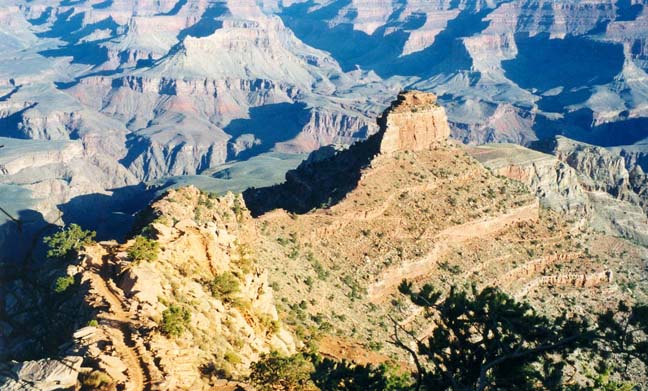
| Start of South Kaibab Trail | O'Neill Butte from Cedar Ridge |
A regular bus service runs from the South Rim Village to the South Kaibab Trailhead (elevation 7260ft). From that trailhead you almost literally drop over the rim. The first phase descends the very steep upper wall of the canyon by means of a spectacular series of switchbacks cut into a recess in the otherwise unnegotiable cliff. At the bottom of the rim cliff you then emerge onto a talus slope and the trail contours along this slope to the apex of the South Kaibab ridge below Yaki Point. For most of the descent from this point to the Tonto Plateau, the trail follows Cedar Ridge and allows access to frequent sensational panoramas sometimes to the west, sometimes to the east. Shortly after gaining the apex of the ridge and 40min from the trailhead, you arrive at the Cedar Ridge Resthouse with its magnificient views, 1.5mi down the trail at an elevation of 6320ft.
Continuing on, the trail proceeds around the east side of O'Neill Butte, descends to a flat-top mesa and then drops off the end of the mesa down through a quite dramatic chute. Below this it reaches down to the Tonto Plateau where there is another resthouse at the intersection of the South Kaibab Trail and the Tonto Trail (elevation 4000ft). A few yards beyond that junction, the trail plunges off the edge of the Tonto Plateau at a place appropriately named the Tipoff (4.4mi from the trailhead). Suddenly, dramatic and precipitous views of the Colorado open up as the trail snakes down the steep walls of the Inner Gorge toward the river. The rock changes from the red and white sandstone of the upper cliffs to the black and green colors of the Vishnu Schist. This change is called the Great Unconformity, a name that would be pretentious anywhere else but in the Grand Canyon. Finally, 6.3mi and 3hr from the rim, you arrive at the bottom of the Grand Canyon where the river elevation is 2480ft. Just short of the river, you will come to a trail fork; the left trail proceeds west along the precipitous south bank (cliff) of the river. Take the right fork that leads, via a short tunnel, to the Kaibab or ``Black'' Suspension Bridge. Crossing the bridge you then pass Boat Beach just downstream on the north shore. This is a good place to rest and to wade in the Colorado River. However, the water is usually much too cold to swim in even when the air temperature is sweltering. But the river is magnificient, fast and powerful. It was hard to see how one could possibly cross it safely without some sort of boat.
 | 
| |
|---|---|---|
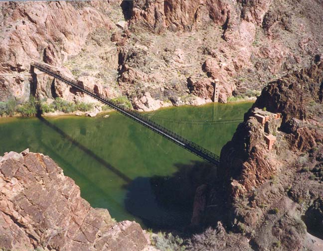
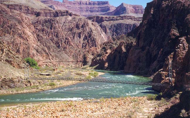
| South Kaibab Suspension Bridge | Colorado by Bright Angel Creek |
When you resume hiking, it is only about 0.4mi to Bright Angel Campground perched on a narrow strip of land along the west bank of Bright Angel Creek just above the point where it empties into the Colorado. Another 0.5mi up Bright Angel Creek brings you to Phantom Ranch, 6.9mi from the South Kaibab Trailhead. The Ranch has a number of cabins available for rent (about $63 per night in 1999) though these are booked many months in advance. It also has dormitory bunk beds at $23 per night. It is a pretty and serene little place amid the relatively luxurious foliage of Bright Angel Creek. If you can find a way to rent a room or bunk here it would avoid the need to carry a full pack down into and then up out of the Canyon.
The return trip begins when you make your way down Bright Angel Creek to the Silver Suspension Bridge over the Colorado River. Interestingly this second bridge serves another purpose besides allowing hikers to cross the river. It also carries the high pressure water pipeline that supplies the South Rim with water from a spring source to the north. This pipeline is routed through Indian Gardens where the pumping station is close to the Bright Angel Trail.
After crossing the Silver Suspension Bridge, follow the River Trail westwards along the south side of the Colorado River. This section is unpleasantly sandy until it begins climbing a steep bluff where the river makes a left turn. Turning the corner the trail descends again to the small, rocky beach where the Bright Angel Trail meets the Colorado, 2.1mi and 1hr from Phantom Ranch. Here the trail enters a small narrow canyon and begins the long ascent back to the rim on the historic Bright Angel Trail.
The upper part of the Bright Angel Trail was originally used by the Havasupai Indians to commute between the rim and Indian Gardens. Prospectors, looking for gold, improved the trail at the end of the last century. Then one enterprising prospector, Ralph Cameron, realizing that there was more money to be made from the tourist trade than from mining, bought out his companion's interests in the trail and set up a toll booth, charging sightseers $1 to venture down below the rim. He also extended the trail to the Colorado. It was only after a long battle with Cameron that the National Park Service took over the trail in 1928.
Leaving the River Resthouse, elevation 2400ft, the Bright Angel Trail first winds its way gently up the the pleasant canyon of Pipe Creek. After about half a mile you pass a pretty, mossy waterfall on the right wall and shortly thereafter, the trail leaves the creek bed and climbs up the steep right wall of the canyon using a series of switchbacks known as the Devil's Corkscrew. The name refers to the fact that this is usually the hottest segment of the trail with temperatures in the summer that often reach 130 degrees. The black rock of the Vishnu Schist mercilessly absorbs the sun and bakes the air. Even on a March day it was close to 90 degrees. However the trail soon emerges from the Devil's Corkscrew and transitions into the next canyon through which Garden Creek runs. As you make this transition, the lovely sounds of flowing water float down to you and soon you can soak your head in the water of Garden Creek under the shade of willow trees. The next section is much more pleasant as the trail winds its way up through the Tapeats Narrows, the canyon of Garden Creek, finally (at an elevation of about 3800ft) emerging from the Inner Gorge onto the Tonto Plateau. From the trail you may see hikers on the Plateau Point trail over to your right. Soon you will also begin to encounter the trees and bushes of Indian Garden and, 1hr 35min after leaving the Colorado, you will arrive at that busy and attractive oasis.
|
|---|
| Top of Bright Angel Trail |
The focus of life at Indian Garden is, of course, the water fountain
with its multiple spigots where you should drink your fill and replenish
your water bottles. The benches surrounding the water fountain
are a very popular rest area.
Above Indian Garden, the trail initially proceeds into the head
of the canyon until it seems almost directly below the rim. It then begins
a long series of switchbacks as it climbs the increasingly steep wall below
the rim. This section is known as Jacob's Ladder
and involves a long
and arduous climb. There are two self-explanatory rest houses along the
way. An hour out of Indian Garden you arrive at Three-mile Resthouse
(elevation 4720ft),
perched on an outcropping with one of the better views from the Bright
Angel Trail. Beyond Three-mile Resthouse, the trail has been cut into
the cliff, the natural slope being close to vertical. One-and-a-half-mile
Resthouse (elevation 5720ft)
sits on a rock slope and presages the last 1000ft up a
natural break in the cliff wall. The Bright Angel Trailhead
comes into view at the end
of a long switchback just below the rim (elevation 6860ft). The total
distance from the river to
Bright Angel Trailhead is 7.7mi and the climb can be
accomplished in about 4.5hr (5.5hr of hiking from Phantom Ranch)
plus whatever length of extended stop you choose to take at
Indian Garden.
Christopher E. Brennen