ADVENTURE HIKES AND CANYONEERING
IN THE SOUTHWEST
© Christopher Earls Brennen

|
|---|

|
Hike D10. Zion's Englestead Hollow
- Hiking time: 8.5 hours
- Estimated hiking distance: 7.5 miles
- Elevation gain: None
- USGS Topo Map: Temple of Sinawava or Zion National Park Topographical Map
- Difficulties: About 10 rappels, one measuring 280ft; several swims; some flash flood danger.
- Special equipment: Two 60m ropes (or one 90m and one 60m rope), harnesses and rappeling gear; wetsuits and dry bags.
- Permit: Obtain permit from Backcountry Desk in Zion National Park Visitor Center.
-
ACA Rating: 4A IV

Characteristics
The highlight of this adventure is a descent of Englestead Hollow, a tributary of Orderville Canyon that lies partly outside the eastern boundary of Zion National Park. The hike continues down Orderville Canyon and then through a short stretch of the Zion Narrows, sections which are described elsewhere in this collection of Zion Canyon hikes. The descent of Englestead Hollow is an advanced technical adventure that is only for experienced canyoneers. But for those with such experience it is a spectacular hike, with a particularly challenging initial rappel measuring 280ft into an awesome and vertical slot at the head of the canyon.
Before embarking on this adventure, two strategic decisions should be made. The first concerns your plan for the descent of the initial, 280ft rappel; whether or not to leave a 300ft rope in place for later recovery or to stage the rappel from some airy anchors. The second concerns whether or nor to bring wetsuits; the author recommends that you do so except in the heat of summer.
Trailhead
This hike requires a lengthy car shuttle. Drive first to the Zion National Park Visitor Center (37o12.02'N 112o59.24'W) where you will leave the recovery vehicle. (At the end of the hike you will catch the Shuttle Bus back to the Visitor Center from the Temple of Sinawava.) Drive north and then east through the park, following the spectacular Zion-Mt.Carmel Highway as it climbs the east wall of Zion Canyon before exiting the Park. About 2.5mi beyond the East Entrance to the Park, turn north on a paved road signed North Fork. Drive across the plateau for 5.2m to the turn-off to the left to the Zion Ponderosa Ranch and Resort (this turn-off is just before the North Fork road turns from asphalt to dirt at 37o16.39'N 112o52.40'W). The Resort is the collection of buildings below you on the left and is a good place to stay or camp prior to this adventure. From the entrance gate continue along the dirt road that swerves to the right past the resort. After 0.6mi fork right following the sign to Observation Point; then 1.4mi from the highway you will come to a tee junction where you turn right, forking right again about 100yds further on. The road deteriorates here; follow the most used track for 1.4mi beyond the tee junction, ignoring various spur roads and tracks. This brings you to a fork with equally used tracks to both the left and the right. After just 0.1mi the left fork would take you to a trailhead next to the park boundary (a barbed wire fence) that accesses a trail into the park. You take the right fork which, after 0.5mi ends in a small clearing (37o18.13'N 112o53.95'W and elevation 6500ft) with some room to park. This rudimentary trailhead for Englestead Hollow is the furthest north that the maze of dirt roads penetrate.
Hike
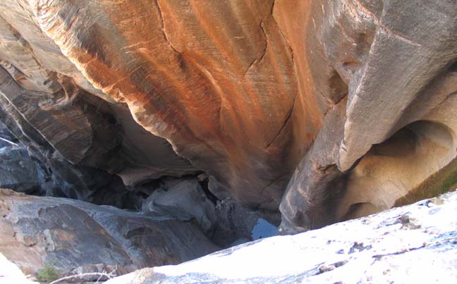
From the unmarked trailhead (37o18.13'N 112o53.95'W and elevation 6500ft), there is a narrow and rough ATV track proceeding east. Follow this for a short distance until you come to an overlook into a wooded gully. A faint use-trail descends into this gully. Leave the ATV trail and follow the use-trail down a short way - but then begin contouring left in order to exit this gully and access the next one to the south. You should soon detect that this second gully descends into a large canyon that is, in fact, Englestead Hollow. Stay close to the watercourse in this shallow gully until forced to traverse left to downclimb a short section of slickrock. Just below the slickrock you will come to the awesome slot near the head of Englestead Hollow. Move right or left a short way to access the head of the slot where the streambed drops almost 300ft. You should reach this point (37o18.32'N 112o53.50'W and elevation 6000ft) about 30min and 0.5mi from the start.
|
|---|
| Looking down into Englestead Hollow |
(Photo by Scott Smith) |
To locate the precise entry point for the descent into the slot, go to the head where the streambed drops over the edge (a very good vantage point). Then proceed around the north (left) side for about 20yds to the conifer at the lip that has the webbing anchor for the first, big rappel. The drop to the bottom of the slot measures 280ft and there are several ways to descend. If you own a 300ft rope the best strategy is to leave that rope in place after the descent and to walk back from the trailhead and recover it at the end of the day. Though this involves a little extra hiking, it has the advantage that you will not have to carry excessive rope through the rest of the hike. If you choose this alternative, then all you will need for the rest of the day is one 200ft rope (plus a short 60ft rope for the convenience of leapfrogging at the many small rappels further down the canyon.
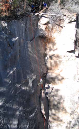 | 
| |
|---|---|---|
| Beginning the big drop into Englestead | Second rappel | |
(Photos by Scott Smith) | ||
Without a 300ft rope you can descend the initial drop with two 200ft ropes as follows. The first descender uses a 200ft single strand to descend 80ft to a bolt station with a narrow ledge in a corner. Have a companion observe this first descender from the far side of the canyon to ensure that the first descender does not inadvertently bypass this midway belay station which is a little off-vertical to the descender's right. The first descender should also bring one end of the second 200ft rope while a companion plays out that rope from the top. Once secured to the belay station with a etrier or sling the first descender should use the the second 200ft rope to set up another single strand rappel from that point on down the wall. The first descender should transfer to it and proceed down about 180ft to a broad ledge near the bottom of the wall. Other members of the party then descend to this ledge. The penultimate descender should wait at the intermediate belay station to aid the last descender. At the top the last person should change the upper rope to a double strand rappel. Once he/she reaches the belay station, the last two people should pull the upper rope and rig it to allow recovery of the lower rope. Once all are on the broad ledge the lower rope can be pulled and a 30ft double strand rappel should be set up using the nearby bolt anchor to complete the first big drop. Note that all this procedure will take more time than coming back after the hike to recover a 300ft rope.
You should reach the bottom of the slot (elevation 5700ft) about 1.5hrs from the trailhead. The big rappel is immediately followed by a 40ft drop from a webbing anchor wrapped around a large chockstone. A pool at the bottom could be knee deep. This is immediately followed by a short 20ft rappel from a webbing anchor around another chockstone. On this descent you will pass a large log to which is attached a long webbing anchor that reaches about 10yds towards the top of the next drop. Do not try to shorten this; replace it with a similar or longer webbing length if you wish to renew the anchor because the next drop takes the full length of a 200ft rope. It uses the long webbing extension as the anchor and is an awkward but beautiful two-stage rappel. You first descend about 15ft into a pool that may be as deep as 3ft. Then climb onto a lip at the exit from the pool and descend another 70ft down an almost vertical wall with a deep groove. Your 200ft rope may not quite reach the bottom but you should not have to drop more than two or three feet. At this point (elevation 5560ft) you have come to the end of the first set of rappels. You should reach this location about 2hr 10min from the morning start.
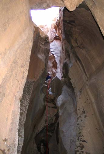
 | 
| |
|---|---|---|
| Fourth rappel | Near the end of Orderville | |
(Photos by Scott Smith) | ||
The first series of rappels is followed by a mile of flat bottomed slot, extending most of the length of Englestead. There are many small downclimbs and about 6 or 7 short (less than 20ft) rappels, several down logjams that have awkward rappel entries. All had webbing anchors when we descended the canyon. At the mouth of Englestead Hollow where it joins Orderville Canyon, there is a larger drop of about 30ft with no obvious anchor. But you can climb about 6ft up on the right to a ledge that has an easy downclimb into Orderville. You should reach the Englestead/Orderville confluence (37o18.89'N 112o54.37'W and elevation 5080ft) about 4hrs 15min from the morning start.
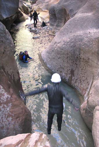
The descent of Orderville Canyon is described elsewhere and need not be repeated here. It is 3.4mi from Englestead to the confluence of Orderville and the Virgin River or Zion Narrows (37o18.49'N 112o56.81'W). All but the last mile or so is fairly level going though in spring or fall you may encounter many muddy pools and some quicksand. Over the last mile the stream becomes more established; there are awkward downclimbs, several into pools that require swimming. In spring or fall a wetsuit is recommended especially for this section. You should reach the Virgin about 7hrs after the morning start.
From the confluence you turn left and head down this, the last last few
hundred yards of the Zion Narrows. Here the stream fills the entire width of
the gorge and together with the immense vertical walls make for a majestic
and awesome spectacle. From the Orderville confluence it will take you about
1.5hrs to reach the end of the hike at the Temple of Sinawava, a
distance of 2.3mi.
After a few hundred yards of the true Zion Narrows, the route consists of
many river crossings interspersed with a well-worn trail along benches to one
side or the other. About ten minutes after you pass another brief stretch of
Narrows where Mystery Canyon enters on the left
(37o17.98'N 112o56.68'W),
you will come to the start of the Riverside Walk, a concrete tourist path
that leads down to the Temple of Sinawava
(37o17.11'N 112o56.86'W and
elevation 4410ft). Here you catch a Zion National Park
tram that will take you back down the canyon to the Visitor Center and your
return vehicle. The hike from the trailhead to the Temple of Sinawava
should total about 8.5hrs during which you will cover about
7.5mi.
Last updated 4/20/04.
Christopher E. Brennen