ADVENTURE HIKES AND CANYONEERING
IN THE SOUTHWEST
© Christopher Earls Brennen

|
|---|

|
Hike C1. Egypt Slots 2 & 3
- Hiking time: 6 hours
- Estimated hiking distance: 4.2 miles
- Elevation gain: 820 feet
- USGS Topo Map: Egypt (UT)
- Difficulties: One rappel of 230ft at start plus one 40ft rappel; much downclimbing and upclimbing, long sections of very narrow slot, some possible pothole escapes and swimming.
- Special equipment: Rappeling equipment, leave 300ft rope at start, 80 ft rope, 20 ft webbing, 1 rappel ring, harnesses, helmets, dry bag and small packs
-
ACA Rating: 3B III

Characteristics
East and north of Lake Powell in the southeast corner of Utah is some of the most remote terrain in the United States. Now the site of the Grand Staircase/Escalante National Monument and the Glen Canyon National Recreation Area this is a parched land of mesas and escarpments, flat at the higher elevations but worn away at the lower into steep canyons and red and white slickrock. Southeast of the small town of Escalante in Utah lies the lower canyon of the Escalante River as it winds its way down toward its junction with Lake Powell and the Colorado River. Numerous tributaries feed their storm water into the Escalante and many of these have carved fantastic sculpted canyons through the red Navajo sandstone. The Egypt Slots and Neon Canyon featured in this collection represent just three of hundreds of examples of these slot canyons.
The Egypt Slots described here are examples of incredibly narrow and deep streamcourses, so narrow in fact that a relative thinly built person will have to squeeze through many tens of yards of slot canyon about 10in wide. More heavily built individuals should NOT attempt the Egypt 3 slot unless they are agile enough to climb higher and stem past these narrow sections. There are also hundreds of yards of slot about 1ft wide and these can tear away at skin and clothes so you need to come prepared. It is also not a place for those who may feel claustrophobic.
We describe here a hike that takes in both the Egypt 2 and Egypt 3 slots by descending the first to near their confluence and then ascending the second. The hike is done in this direction because a drop in Egypt 2 that must be rapelled can not readily be ascended. But each slot can be descended individually with return legs on the slickrock ridgetops to the east of each of the two canyons.
Trailhead
To reach the trailheads for the Egypt 2 or Egypt 3 canyons starting in the town of Escalante, Utah, you drive east along the paved Highway 12 for about 5mi to the well-marked turn-off to Hole in the Rock Road. Turn right onto this high-quality dirt road and drive 16.7mi southeast over a gently rolling mesa to where there is a turn-off on the left to the Egypt Trailhead. Turn left and drive down this less developed dirt road. You might note a nice campsite on the left just 0.5mi down this spur road, a useful stop after the long drive to get here.
The Egypt road gradually worsens as you proceed and is recommended only for high clearance vehicles though a regular car can make it with a little careful obstacle avoidance. It is 8mi to the Egypt 2 trailhead where you can pull off onto the slickrock on the right at 37o34.86'N 111o14.55'W and an elevation of 5360ft. It is only a few yards from there to the top of the dramatic 230ft drop into the head of the Egypt 2 canyon. If you wish to leave a second vehicle at the point where you exit Egypt 3 then continue up the road for another 1.5mi to the where the dirt road forks and park the return vehicle there. Your probable exit point is a few yards back down the road at 37o35.63'N 111o13.76'W and an elevation of 5610ft.
Hike
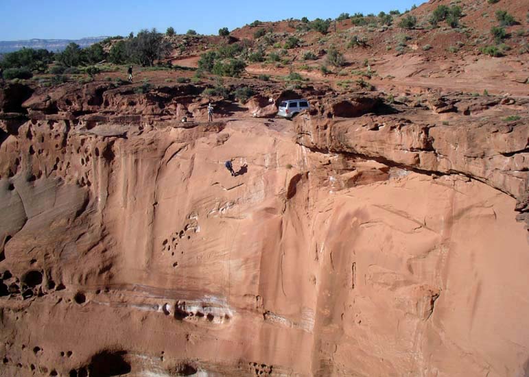
The drop-in to Egypt 2 is immediately beside the slickrock parking area at 37o34.86'N 111o14.55'W and an elevation of 5360ft. Probably the most comfortable place to set up the first big 230ft drop-in rappel is a few yards to the west of the head of the canyon where you can back a vehicle up to within a few yards of the lip and use it to anchor the rappel (see photograph). Rappel down 230ft into this deep slot, leaving the long rope in place until you return from the hike. If you wish to bypass this rappel you can do so on canyon left by walking about 0.3mi around the rim on the left to a large gully where you can walk down into Egypt 2.
|
|---|
| The 230ft rappel into Egypt 2 (Photo by Sonny Lawrence) |
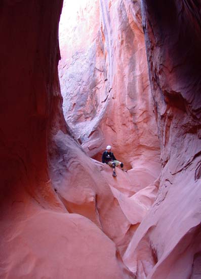
Once in the slot bottom, there are a number of downclimbs to negotiate in addition to some narrow slot. About 1hr from the start you come to a ``tunnel'' at 5080ft and, shortly after, to the second rappel, a 40ft drop from a chockstone anchor in a narrow slot. Downstream of the rappel more slots and downclimbs continue. In addition at 4900ft and 1hr 40min from the start, there are several small but potentially troublesome potholes followed by several hundred yards of shoulder width slot. The narrows are almost continuous in this lower section of Egypt 2 but 2hrs 20min from the start at about 4790ft they finally open up into a broader wash that will continue down to the confluence with Egypt 3.
However, this hike exits Egypt 2 before that confluence. Shortly after Egypt 2 opens up you will encounter a short, narrow slot in the bottom of the broad wash and 100yds beyond this slot this hike exits Egypt on the left at 37o33.71'N 111o14.83'W and an elevation of 4780ft. Here you will be about 1.5mi and 2.5hrs from the start. The exit is up moderately sloped slickrock where the canyon turns left. There is a notable, single 3ft boulder perched alone on the slope about 20ft up this slope. Climb about 100ft up this slickrock to a shoulder between Egypt 2 and Egypt 3 and then contour upstream (left) into the relatively broad wash of Egypt 3.
 | 
| |
|---|---|---|
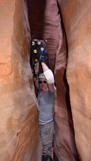
| In lower Egypt 2 | Tight squeeze in lower Egypt 3 | |
(Photos by Mark Duttweiler) | ||
Though there is a rappel downstream of your point of entry into Egypt 3 the first part of the ascent from this point is a relatively easy hike up a broad shallow valley. This suddenly changes at 4830ft and 3hrs (2.2mi) from the start where the canyon shrinks to an extremely narrow slot, a place where only the thinner people can make it through without ascending to stem across at a higher level. This is where a small pack is really advantageous for you will probably have to carry it overhead. A number of these very narrow sections (width about 10in) are interspersed with only slightly wider stretches. After about 0.3mi you will come to the end of this first narrow section where the canyon forks at 37o34.41'N 111o14.04'W and an elevation of 4940ft (2.5mi and 4hrs from the start). Turn left here at this first fork where there is a brief, slight more open section. However the canyon soon narrows again though never to the extreme of the earlier stretch.
About 25min from the first fork you come to a second at 37o34.86'N 111o13.86'W and an elevation of 5020ft. Fork right here (less obvious than the first fork) and enter a lovely sculpted section of Egypt 3 with lots of contorted slot and a number of small potholes. A fair amount of upclimbing is demanded here and some will need a partner assist in places, especially if you try to avoid getting wet. Finally, about 5hrs 10min and 3.4mi from the start at an elevation of 5160ft you emerge from the slot onto a wash. Directly ahead in the distance you should see a broad and tall slickrock wall rising up to the horizon. This is the exit route. To get there continue up the wash until you come to a small upclimb past a chockstone. Then backtrack about 30yds to where you will see a small steep gully on the right (looking upcanyon). This should also be marked by several cairns on the shelf overhead including one neat arch cairn. You should reach this exit point at 37o35.15'N 111o13.70'W and an elevation of 5170ft about 3.5mi and 5hrs 15min after the morning start.
Begin the exit climb by ascending this gully for about 50ft and then contouring left along a broad ledge and into a much larger gully coming down from the right. Cross this gully and begin switchbacking up the aforementioned slickrock choosing easy traverses until you reach the rim at a place where rockfalls have made the last step fairly easy. Once above the rim follow the use trail that proceeds up some minor benches to reach the rough dirt road. Your return vehicle should be just a few yards along the road to your right at 37o35.63'N 111o13.76'W and an elevation of 5610ft. The total hiking time is about 6hrs during which you travel about 4.2mi. If you did not leave a return vehicle here the hike back down to the Egypt 2 trailhead is a fairly easy 1.2mi jaunt.
Many thanks to Steve Ramras and his family for their guidance in this
Escalante region.
Last updated 5/18/07.
Christopher E. Brennen