ADVENTURE HIKES AND CANYONEERING
IN THE SOUTHWEST
© Christopher Earls Brennen

|
|---|

|
Hike A10. Devil's Canyon, Arizona
- Hiking time: 7.5 hours
- Estimated hiking distance: 5 miles
- Elevation gain: 880 feet
- Topo Map: Superior
- Difficulties: Five rappels up to 60ft, deep pools to swim and some class 4 climbing
- Special equipment: 160ft rope, 60ft rope, 30ft webbing, 5 rappel rings, harnesses, helmets and drybags
-
ACA Rating: 3B III

Characteristics
Devil's Canyon in the Tonto National Forest of Arizona gathers strength in the Pinal mountains northeast of the town of Superior and slices through the high desert on its way south to join Mineral Creek and eventually the Gila River. In the process it has cut a rugged high desert canyon lined with great balustrades of sculptured pinnacles and decorated with magnificent Saguaro cacti. Here you will see a full spectrum of desert wildlife from golden eagles to havolinas to Gila monsters. Where water flows the canyon bottom is lush with sycamores and alders that provide welcome shade from the blazing desert sun. It is a beautiful place unfortunately not yet fully protected from possible destruction by the mining companies.
This adventure takes you down Devil's Canyon to a remote and spectacular place where the canyon narrows dramatically and drops several hundred feet in a few hundred yards through a series of beautiful waterfalls and cliff-rimmed plunge pools. It is an exciting technical challenge to descend through this hanging gorge by rappelling and swimming. Fortunately there is also a reasonable route by which to climb back to the top of the falls and thus to return by the same route to the trailhead. It is an adventure that is best for a spring, summer or early fall day when the temperature is high enough to enjoy spending much time soaking wet.
Trailhead
From Superior, Arizona, drive east on Highway 60, climbing into the Pinal mountains and the Tonto National Forest. Just 4.0mi east of Superior turn right onto the Oak Flat Campground road (Forest Road 469). Drive down this asphalt road passing the Oak Flat campground on your left. About 1.5mi from the highway look for an unmarked dirt road turnoff on the left which is gated. Open the gate, proceed through and close it after you. After just about 100yds you should pass a small reservoir to your left (you may need to ford a small stream on the way). About 1.7mi from the gate you will have descended a slope into a small meadow with a cow tank. You are now in the Rancho Rio Creek drainage at 33o16.94'N 111o3.01'W and it is possible to hike down Rancho Rio Creek to access Devil's Canyon. But the author recommends that you park here and continue hiking along the road which is very rough after Rancho Rio Creek. The road climbs steeply up to a ridge and descends into the next drainage, known as Hackberry Creek. Proceed down into the Hackberry Creek drainage to the corrals and the windmill at the south end of the meadow in the creek bottom; these are 2.5mi from the asphalt road. The times and distances hereafter assume that you are starting at the Hackberry Creek windmill (33o16.50'N 111o2.42'W). Note that it takes an additional 20min to hike from the Rancho Rio Creek trailhead to this starting point.
Hike
From the Hackberry Creek windmill (33o16.50'N 111o2.42'W and elevation 3920ft), hike down the road for about 100yds and then continue down the drainage. The going here is easy with lots of bedrock and only a little brush. Soon the sides of the canyon close in, decorated with great columns of sculpted rock and a maze of hoodoos and sprinkled with statuesque Saguaro cacti. This is not only a beautiful canyon but also an outstanding climbing venue with many bolted routes; it is well documented in the climbing guide, "Queen Creek Canyon" by Marty Karabin published by Chockstone Press. After just 25min you arrive at the top of a 40ft dryfall, the only real obstacle in Hackberry Creek. Climb down the ledges and narrow slot on the left side until about 6ft above the large pool and then follow a broad ledge all the way across to the right to avoid the pool. Continue down this lovely little canyon. After contouring around to the left of another pool at the end of Hackberry Canyon, you will arrive at the forested junction with Devil's Canyon (33o16.42'N 111o1.65'W and elevation 3540ft) about 45min and 0.8mi from start. Though the junction is already marked by many cairns, pause to take note of the surroundings so that you will readily recognize it upon your return.
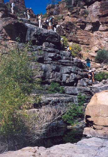
At the junction turn right and hike south (downstream) through a very pleasant wooded canyon. Devil's Creek normally has running water all the way to our destination. There is a faint use trail on the right side of the canyon and the going is initially easy with little brush. Soon, however, there are more boulders and pools to negotiate and about 90min from the start you come to the first significant obstacle, a slot waterfall with a 15ft downclimb in midstream. Thereafter the route continues to be rugged with much boulder hopping and some bushwhacking. The use-trail (actually a cow trail since cattle run in this canyon and do significant damage) mostly follows the right side of the canyon bottom though there are several places where you detour a little higher on the right side to avoid deep pools. About 2hr 20min and 2mi from the start the broad and open canyon makes a sweeping left turn. Just beyond the turn, at 33o15.41'N 111o1.35'W and an elevation of 3380ft and 2.3mi or 2hr 30min from the start, Devil's Canyon suddenly narrows and drops precipitously through a series of dramatic waterfalls and deep plunge pools. These are the Devil's Canyon cascades you have come to see. You need to don your harness and helmet, store your belongings in a drybag and prepare for much swimming and rappelling.
 | 
| |
|---|---|---|
| Dryfall in Hackberry Creek | Second drop and swim pool |
At a wide rock gate, the first waterfall drops 12ft vertically into a large and deep plunge pool. There is a bolt anchor on the left wall at the lip; usually a knotted rope hangs down from this anchor and, since there are many good fotholds, this allows an easy downclimb on the left to a broad, flat shelf just above the level of the pool. If the knotted rope seems unsafe, install your own short rope here and leave it for your later return. Then swim about 15yds across this first deep pool to another wide and flat shelf at the top of the next drop. However, before tackling the next drop, you should inspect the left wall of the canyon directly above you in preparation for the return trip. Notice a shallow crack below a shelf about 35ft above you. The crack has a small, sturdy bush growing at the top. The preferred return route descends from the shelf down this broad crack. The first section of this descent is a little exposed but the rest is easy with many good footholds and ledges. If you identify the crack you may wish to prepare for the return by climbing up to the bottom end of the crack to familiarize yourself with the class 4 downclimb. Once this is done you are ready to resume your descent.
 | 
| |
|---|---|---|
| First big drop and swim | Second big drop and swim |
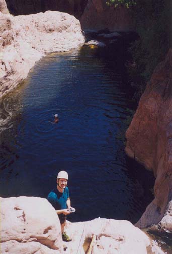
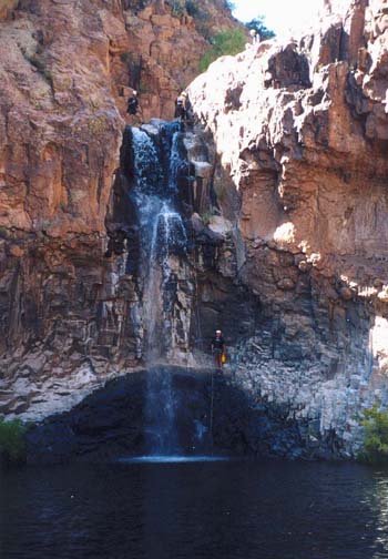
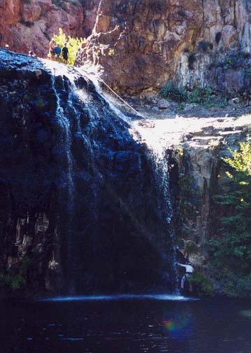
Slide down a short chute below the wide and flat shelf into a small pool and climb out onto a small platform to the left of the next falls. The bolts for the next short rappel are in the wall at the back of this small platform. There is often a permanent rope installed here but it is better to set up your own 12ft rappel. You drop down into a large deep pool; there is a good submerged step just beside the waterfall that avoids a swimming disconnect. Once off-rappel swim about 20yds across the pool to a rock platform to the left of the next lip. If you have a 160ft rope in addition to that which you used for this small drop you may wish to leave the rope in place at the 12ft rappel for the return trip. At the end of the 20yds swim, clamber up the steep rock onto the top of a platform that is about 4ft above the top of the next waterfall. The next drop is a spectacular 50ft vertical falloff into a huge round plunge pool almost completely surrounded by vertical cliffs. The anchor is a pair of solid bolts on top of the platform. The 50ft rappel is free for part of the descent but drops onto a shelf near the bottom. You can either disconnect and climb down from this shelf into the pool or rappel all the way into the pool and do a swimming disconnect. The last person should pull the rope and transport at least one end across the pool for the next rappel. It is an awesome 30yds swim across this cliff-encased pool to a broad lip at the far side.
The next rappel is currently anchored from a small tree on the left side of the lip. If this tree perishes, new bolts will be needed for there are no other solid anchors. It is a two-stage, 50ft descent on the left side of the falls, first dropping about 15ft to a sloping and slippery shelf and then a 30ft vertical descent into a deep pool where a swimming disconnect is unavoidable. Again the last person needs to pull the rope. Another 30yds swim across a large deep pool brings you to a narrow and sharp lip that is followed by a 10ft drop onto a broad shelf. There is a stout little tree on the right side of the lip that can be used with a piece of webbing or rope to descend the 10ft to the shelf. Leave the rope or webbing in place for you will need to ascend again to this lip. (There is also an easy downclimb just to the left of the 10ft falls). If you wish to get all the way to the bottom of the Devil's Canyon gorge there is an obvious route on the right where you can descend over boulders to the wooded bottom where the canyon veers right and broadens (elevation 3030ft).
You should complete this spectacular series of descents about 4hr 30min from the morning start. The return is also challenging and to begin climb back up to the broad shelf and then back up to the narrow and sharp lip. To avoid confusion we now switch and use right or left as one looks upstream. On the right side of the lip there is a shelf on the downstream side of a steep rock ridge. Follow this to the right and climb up onto a wide wooded ledge. At the back of this ledge you will find a steep route up a gully that begins with a climb up the roots of a tree. Proceed up the steep wooded slope for about 50ft and then veer left across a steep earth slope toward a notable shoulder. Climbing up over a notch on the shoulder will bring you to a comfortable shoulder slope. From here you should be able to see two options. Option one is to descend down that slope to the shelf above the 50ft rappel but downstream of the 12ft rappel and pool. This route would then require a swim across the pool and a prussik ascent of the 12ft rappel. Option two is a little more exposed and was described earlier. From the shoulder slope proceed a short way along a shelf to the bush at the top of the descent crack that takes you down to the rock shelf at the top of the 12ft rappel; this option avoids the awkward prussik ascent.
The final step in the ascent is to swim across the top pool to the shelf
at the bottom of the 12ft knotted rope. The last ascent using that
rope is quite easy because of the numerous footholds. You should complete
the ascent in about 30min and thus return to the top about
5hrs after the morning start. The hike back up Devil's Canyon and
then up Hackberry Creek to the trailhead
(33o16.50'N 111o2.42'W)
should take about
2hrs 30min. The total duration of the adventure is about
7hrs 30min during which you cover about 5mi.
Christopher E. Brennen