ADVENTURE HIKES AND CANYONEERING
IN THE SOUTHWEST
© Christopher Earls Brennen

|
|---|

|
Hike K24. Deep Canyon
- Hiking time: 6.5 hours
- Estimated hiking distance: 5.2 miles
- Elevation gain: 630 feet
- USGS Topo Maps: Toro Peak, Rancho Mirage
- Difficulties: 6 rappels (some wet)
- Special equipment: Rappelling gear, helmets, 160ft rope, 160ft recovery cord, 80ft webbing, 6 rappel rings, drybags
-
ACA Rating: 3B III

Comment:
Please note that the Boyd Deep Canyon Desert Research Center (http://deepcanyon.ucnrs.org) located at the exit from the canyon claims to have exclusive right of access to Deep Canyon. Canyoneers are warned that they may be subject to prosecution if they enter this canyon. The author made the descent unaware of this restriction since there were no warning signs at the drop-in location.
Characteristics
Just south of the retirement community of Palm Desert, California, in the scorching Coachella Valley, the contiguous San Jacinto and Santa Rosa mountain ranges rise precipitously from the valley floor. These rugged desert ranges present a formidable obstacle to travel southwestwards out of the Coachella Valley. One of the few roads that proceed over the mountains in this direction is Highway 74, the so-called ``Palms to Pines'' highway that switchbacks tortuously up a minor gap between the two mountain ranges. It is also one of the few ways to access the hidden beauty of these desert mountains.
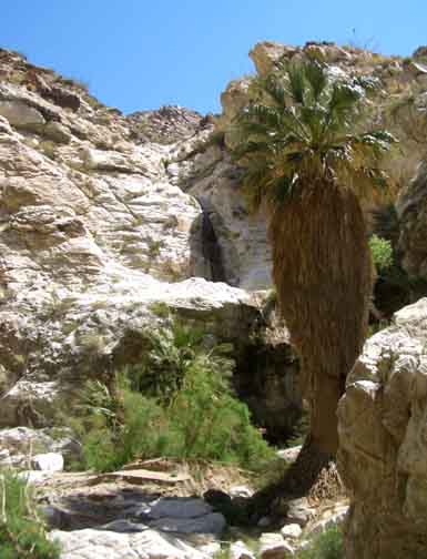
The pass that Highway 74 follows between the two ranges was primarily cut by a drainage route that now takes the form of a huge deep canyon called, appropriately, Deep Canyon. Over 1000ft deep, this chasm is not readily visible from from the highway, but is easily identified from the air (the author first noted it when flying from LAX to Washington, D.C.). Flash floods from the high plains around Pinyon Flat have cut this great desert gorge down to the white crystalline rock that sparkles in the bottom of Deep Canyon. Because of its ruggedness and relative inaccessibility, this land is still home to many desert creatures and to the Santa Rosa Mountains State Game Preserve. Though most of the visible surfaces of these mountains are dry, barren desert, hidden away in the depths of the canyons are verdant oases of cacti and palms and, in a few rare places, the magic of a running, sparkling desert stream. Deep Canyon is one such jewel.
This hike takes you down into the furthest recesses of Deep Canyon, accessing it by descending a steep side canyon called Hidden Palm Canyon. This approach requires several long rappels. Though Hidden Palm is normally dry, a small stream flows through Deep Canyon most of the year and there is a lovely little waterfall at the confluence which provides welcome relief on a hot day. Deep Canyon itself is a beautiful, white rock canyon decorated with the crystal stream and the green palms and cacti it supports. There are several wet rappels and a glorious section of narrows before the canyon opens up, the water dries up and you emerge into the hot desert. The climb back to the road is very arduous on a hot day. Consequently this hike is best for the late winter or early spring.
Trailhead
Take the Monterey Avenue exit from Interstate 10 in Palm Desert, California, and drive south through Palm Desert. Monterey Avenue becomes Highway 74 (also know as the Palms to Pines Highway); continue south on this highway as it climbs into the mountains south of Palm Desert. Approximately two miles beyond where it first turns left to start climbing you will come to a switchback to the right where there is a large dirt pullout on the right side of the road on the inside of the bend. Here at 33o39.33'N 116o23.73'W and an elevation of 1540ft is where you should leave the return vehicle. Before continuing walk to the east side of the curve where there is a guardrail. From this guardrail you should be able to look down the slope that represents the climb out of the canyon at the end of the hike.
After this reconnaissance, continue up the road in the other vehicle(s) for 5.3mi to a pullout on the right side of the road beside the junction with the private drive signposted ``Big Horn Drive''. Park here at 33o37.30'N 116o24.70'W and an elevation of 3130ft.
Hike
From your vehicle at 33o37.30'N 116o24.70'W and an elevation of 3130ft cross to the east side of the road and start down the gentle sloping wash on the far side, heading due east. This is the start of one of the tributaries of Hidden Palm Canyon and its gentle beginning beguiles what lies ahead. After just 15min at an elevation of 2800ft you will arrive at the top of a dramatic vertical drop of about 100ft. This requires the first rappel. Using a small rock horn close to the lip you descend the 100ft into a clearing with several palm trees.
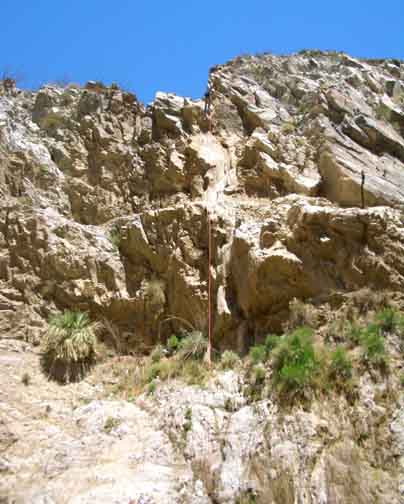
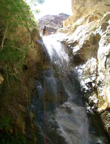
|
|---|
| Third rappel in Hidden Palm Canyon |
This rappel is followed by a number of easy dryfall downclimbs before you come to the second technical obstacle in Hidden Palm Canyon, namely a four-step dryfall at 2520ft and roughly 50min from the start. You can downclimb the first 20ft step by climbing up and over to the right, thus dropping into another large gully entering from the right. The second and third steps with drops of about 20ft and 30ft require a rappel that is readily anchored from a boulder in the streambed. Finally, the fourth step is more easily downclimbed than might appear from above.
It is not far from the four-step drop to the last and largest rappel in Hidden Palm Canyon; you should reach this point at an elevation of 2330ft about 1hr 20min after the start. The rappel descends a 160ft vertical drop using a large boulder anchor near the left side of the lip. Downstream of this excitement, a few easy downclimbs bring you to the confluence with Deep Canyon. Before you get there you should be able to hear the sound of running water in Deep Canyon and, on a hot day, the little waterfall at the confluence makes for a marvellous rest stop. You should reach the confluence at 33o37.28'N 116o23.87'W and an elevation of 2100ft about 1hr 40min from the start having travelled about 0.9mi.
Downstream of the confluence Deep Canyon narrows and there are many small downclimbs and waterfalls interspersed with small oases. It is just a short hike of 15min to the first technical obstacle, a small 10ft drop to a pothole followed by a 30ft waterfall. The downclimb to the pothole is awkward but ledges on the left lead to an overhang with a large boulder that you can use to anchor the 30ft rappel down beside the very pretty waterfall. Look up to the right to see a series of high waterfalls in a precipitous side canyon.
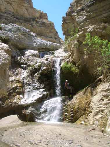 | 
| |
|---|---|---|
| First rappel in Deep Canyon | Deep Canyon palm and side falls |
This is a beautiful section of canyon with frequent waterfalls and it is just a few hundred yards to a series of falls. The first two have no obvious anchor but are readily bypassed on the right by traversing a broad ledge and then downclimbing a steep gully to a sandy flat. You should reach this point at 1930ft about 2hrs 40min from the start. The sandy flat leads immediately to the second rappel in Deep Canyon a 40ft sloping waterfall where you will get wet. The anchor is a wedged rock in a recess up on a ledge to the right of the lip.
Downstream of this series the canyon gradient begins to ease though the downclimbs continue. Here the canyon becomes impressively narrow and deep with towering multicolored walls on both sides. This section culminates in the highest and most spectacular rappel in Deep Canyon which you should reach about 3hr 25min from the start at an elevation of 1750ft. The stream cascades through a small slot and then sprays down about 80ft into a recessed grotto. The anchor for the rappel is three pitons in the rock on the right though there are also boulders you could use. The rappel is gloriously wet.
This last rappel is not the end of the narrows for the slot continues and there are a number of downclimbs to negotiate. However, the walls gradually begin to decrease in height and the going becomes easier. There are several places where you will bypass small falls using ledges on the left and here you may begin to detect signs of a use-trail. Confirmation that you coming near the end of the narrows comes when you encounter a gauging station which you should reach about 4hrs 10min from the start at an elevation of about 1450ft.
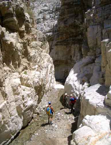 | 
| |
|---|---|---|
| Deep Canyon narrows | Third rappel in Deep Canyon |
Beyond the gauging station the going becomes much easier and faster in the
mostly sandy wash and the canyon continues to open up. Eventually there
is a wide open area on your right and you will pass under electric wires
heading to the east side of the wash to a small encampment of buildings
(a research station). The wash turns north at this point and soon you pass
the end of a prominent lateral ridge on the left. This important waypoint
is at 33o39.17'N 116o22.60'W and
an elevation of 910ft, about 3.9mi from the start.
Here you climb out of the wash and head up the gently sloping
plain (avoiding the numerous chollas) to the north of the prominant
ridge. You should head roughly west aiming for the
lowest point on the ridgeline in the distance. It is, however, a good
idea to veer slightly north of the obvious westerly line for you
will find that you must transition north through a number of gullies
and these traverses are more easily effected on a more northerly
course. At some point about halfway up this slope you should be able to see
a portion of the guardrail of the road ahead of and above you.
On a hot day it is a particularly hard slog up the slope to the road but
hopefully when you reach the asphalt it is indeed where you left the return
vehicle at
33o39.33'N 116o23.73'W and an elevation of
1540ft. You should complete the hike in about 6.5hrs having
covered about 5.2mi.
Last updated 5/6/06.
Christopher E. Brennen