ADVENTURE HIKES AND CANYONEERING
IN THE SOUTHWEST
© Christopher Earls Brennen

|
|---|

|
Hike G13. Darwin Falls, Death Valley
- Hiking time: 3 hours
- Estimated hiking distance: 2 miles
- Elevation gain: None
- Topo Maps: Darwin
- Difficulties: One to three rappels, up to 80ft, a little swimming and wading, bushwhacking
- Special equipment: 200ft rope, 40ft webbing, three rappel rings, rappelling equipment, helmets and drybags
-
ACA Rating: 3B II

Characteristics
Death Valley National Park contains some of the most rugged and fantastic landscape in the world and provides some marvellous adventures and canyoneering experiences. Though the heat in the summer is intolerable, the Park has the advantage that the mild winter weather allows outdoor activity when much of the rest of the southwest is too cold and wintery. While it does occasionally rain in the valleys and snow often covers the high peaks in the winter, at lower elevations the temperatures are perfect for exploring the many narrow, multicolored canyons that line both sides of the flat valley bottom. This collection of adventures contains several in Death Valley National Park. Though the hike to the summit of Telescope Peak is a summer outing, the other, canyoneering adventures included in this collection are best suited for the late fall, winter and early spring. If you plan to do much hiking in the Park, I strongly recommend you buy Michel Digonnet's excellent book "Hiking Death Valley".
Perhaps the wettest canyoneering adventure in Death Valley is a descent of Darwin Creek. The profuse springs in the canyon create a year-round flow with waterfalls and pools that are a delight on a hot day. Located on the far west side of the park on the west side of Panamint Valley in the Argus mountain range, Darwin Canyon is close to the Panamint Springs resort. Dirt roads provide easy access to both the top and bottom of the canyon and allow for a short but challenging half day hike with a spectacular 80ft rappel beside a beautiful waterfall. Prepare for bushwhacking and swimming.
Trailhead
This hike requires a 4WD drive shuttle though the canyon can be explored from the bottom with a single 2WD vehicle. Access is from Highway 190; one mile west of the resort of Panamint Springs a graded dirt road branches off to the south (36o20.41'N 117o28.82'W). Crossing Darwin wash it follows the left or southeast side of this broad gravel wash for 2.5mi to a small parking area, the Darwin Falls trailhead (36o19.68'N 117o30.89'W and elevation 2500ft). Park one 4WD vehicle here (or the single 2WD car if hiking in from the bottom) and then proceed up the rougher dirt road in the other 4WD vehicle. The road climbs to a saddle at 3760ft and then descends to a wash which it follows that all the way to the end of the road at China Garden (36o18.88'N 117o31.95'W). Park there. The distance from car park to car park is 5mi. At China Garden there is a small camping area under a grove of trees and the remains of a mining operation.
Hike
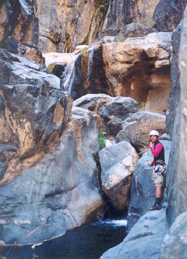
Hiking downstream from China Garden (36o18.88'N 117o31.95'W and elevation 3130ft), you pass through a metal barrier across the wash (labelled Darwin Falls Wilderness) and then continue along a broad gravel wash for about 0.6mi to where you encounter thick brush, the result of a regular near-surface water source. A trail on the slope to the right bypasses the first area of brush but soon descends to the canyon bottom just before the entrance to the first narrows. Follow the use-trail as it crosses to the left bank of the stream; on that side you can follow the rock ledge as the stream enters the first narrows (36o19.08'N 117o31.51'W). The streambed itself is choked with cane and, in places where the ledge disappears you have to push through the cane to make progress. At some point it is better to cross to the ledge on the right side until you arrive at a point where the canyon turns right and the stream drops through a series of small waterfalls. Here there are two alternatives. The driest is to continue to follow the ledge and use-trail on the right. This ends up crossing a somewhat unstable rockslide with exposure high above the stream before descending a break in the cliffs to the streambed at a point below the small waterfalls. The other possibility is to cross to the left side of the stream above the falls and to work your way down with several small downclimbs or rappels. The last small waterfall is just a few feet in height but it empties into a canyon spanning pool that involves a deep wade or swim. You should reach this point (elevation 3000ft) about 1.3hr (and 1mi) after starting out.
|
|---|
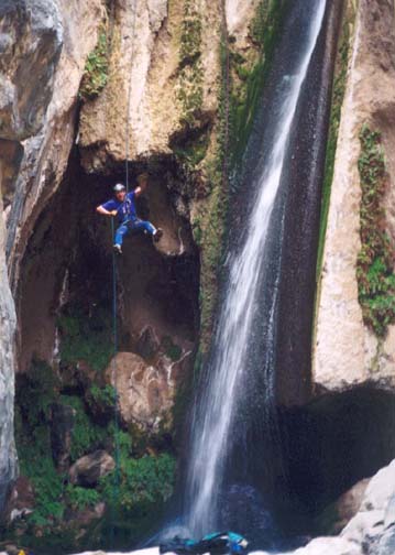
| Author enjoys Darwin Falls |
(Photo by John Perry) |
Downstream of the first narrows follow the well-worn use trail on canyon left for a short way and you will shortly come to a large drop-off where the stream drops vertically about 80ft into a deep slot with many pools and smaller waterfalls down below. This is Darwin Falls (36o19.24'N 117o31.53'W). Using the tree a short way back from the lip you can rappel down 80ft beside the falls to the edge of a the plunge pool at the bottom. It is a spectacular rappel alongside a free-falling waterfall. Note that it is best to guide the rope into a prominent V-notch at the lip to avoid ending up in the water stream itself. From the landing area you must then wade or swim across the plunge pool to a rock platform in between pools. There are two more, smaller waterfalls in this grotto which can rapelled if you wish using as anchor one of the rock horns on a ledge on the left side. Alternatively you may choose to bypass these by following the use-trail on that same ledge as it climbs up through a gap on the left. This leads to a talus slope with an easy downclimb to the base of this series of waterfalls (elevation 2800ft). Note that the descent through this grotto can be completely bypassed by climbing further up the talus slope to a broad ledge that contours around to just above the big drop; if you have difficulty with the rope recovery from the 80ft rappel this bypass could be very useful.
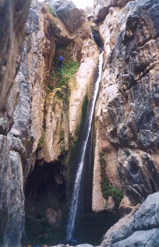 | 
| |
|---|---|---|
| 80ft Darwin Falls (Photo by John Perry) | Second and third falls |
Downstream of this rock and water grotto, the canyon broadens a little and is overgrown with trees and brush. It is only about 100yds to the top of the last waterfall, an interesting 35ft drop into a knee-deep pool surrounded by trees. This is readily rappelled from a tree anchor. (There is also a well-worn high bypass around this waterfall on the right side of the canyon.)
From this last waterfall
(36o19.25'N 117o31.39'W),
there is a good trail that first winds through
the lush canyon bottom (and a gauging station at 1.2mi)
before the canyon broadens and dries out to a wide gravel wash. It is an
easy hike down this wash to the trailhead
(36o19.68'N 117o30.89'W and
elevation 2500ft)
where you left the recovery vehicle. The total time for the hike
should be about 3hrs and the distance 2mi.
Last updated 11/20/03.
Christopher E. Brennen