ADVENTURE HIKES AND CANYONEERING
IN THE SOUTHWEST
© Christopher Earls Brennen

|
|---|

|
Hike K25. Cougar Canyon
- Hiking time: 11.5 hours
- Estimated hiking distance: 8.3 miles
- Elevation gain: Small
- USGS Topo Maps: Hot Springs Mountain, Borrego Palm Canyon
- Difficulties: A long adventure with 13 rappels (some very wet), much bouldering, downclimbing and bushwhacking; several chest-deep wades
- Special equipment: Rappelling gear, helmets, 160ft rope, 60ft webbing, 8 rappel rings, drybags
-
ACA Rating: 3B IV

Characteristics
One of the many spectacular features of the vast Anza Borrego Desert State Park in California is the great escarpment separating the mountains in the center of the state from the flat desert to the east. Driving east from the California coast you climb over a distance of about 35mi through a series of modest mountain ranges to an altitude of about 5000ft before reaching the edge of this great escarpment, a sudden drop of about 4000ft to the desert floor. In doing so your surroundings change from farmland and forest to raw and beautiful desert. The escarpment itself is intersected by rugged canyons worn by eons of rainfall cascading down the steep slopes only to disappear into the desert. It is wild and inaccessible land where man ventures into the margins at the top and bottom, but rarely in between. Cougar Canyon is one of those precipitous canyons intersecting the escarpment and this adventure takes you down its entire length from the Los Coyotes Indian Reservation above its head to where it empties into the desert floor of the Anza Borrego State Park. It is a tough, demanding and lengthy adventure through a canyon unvisited by man except for short sections at the top and bottom. There are at least thirteen substantial rappels often with deep pools in addition to extensive downclimbing, bouldering, and bushwhacking. Only those with substantial canyoneering experience and considerable fitness should attempt this adventure.
But for those that do, the rewards are a fantastic wilderness experience through a beautiful canyon with spectacular waterfalls that feed glorious vegetation varying from open woodland at the top to exotic palm groves and spectacular cacti near the desert floor. Water flows through the canyon year round and so this essential element is assured. The main strategic difficulty with the adventure is the fact that the descent from the vehicle access point at the top to the vehicle access point at the bottom is almost 12hr. Some may choose to overnight in the canyon and split it into a two-day trip but this involves manhandling larger packs through the numerous rappels and downclimbs. My own preference would be for a one-day descent set up by preparations the previous day. These involve leaving a return vehicle at the bottom, driving around to the top and camping overnight close to the starting point. Then, by starting to hike as the dawn breaks, you should be able to make it to the return vehicle before sundown provided you embark on the adventure in the spring or fall. It follows that this is a springtime adventure best undertaken in April or May when the days have lengthened, the water is not too cold and the temperature in the desert is not too extreme.
Trailhead
The adventure requires a long car shuttle that is best accomplished with 4WD vehicles. One or even two 2WD vehicles could be used though the hike may have to be lengthened a little due to the deteriorating roads as you venture into the wilderness from either the top or the bottom. As we recommend above, the car shuttle needs to be set up the day before. You should then car camp at the top end in order to start the hike just after dawn.
The lower trailhead is in Coyote Canyon north of the small town of Borrego Springs. From Christmas Circle in the center of Borrego Springs drive 0.5mi east on Highway 79 and turn left onto Di Giorgio Road. Then drive due north for 4.8mi to the end of the asphalt. Set the odometer to zero here and continue along the sandy dirt road through the desert garden known as Ocotillo Flats. Shortly after this the road crosses the normally dry First Crossing to the west side of the broad canyon. At 3.8mi you come to the first wet ford of Coyote Creek called Second Crossing where the depth of the water may be up to 18in. If one or both of the vehicles are 2WD, then you must park the return vehicle here. If both vehicles are 4WD you should proceed through this ford and continue about another mile to the similar Third Crossing. Just beyond this the road veers sharply west and enters the notorious "Boulder Alley" where it climbs about 400yds up a very rough boulder-strewn draw that will stop all but those willing to risk damage to their vehicles. I recommend parking the return 4WD vehicle at the Third Crossing or at the bottom of the readily recognized Boulder Alley (33o22.48'N 116o26.11'W). Then, in the other vehicle(s), return to Borrego Springs with all your camping gear, hiking equipment and people.
To reach the upper trailhead drive about 27mi west on State Highway S22, west on S2 and then a short way north on Highway 79 to Warner Springs. Just south of the center of Warner Springs, locate the turn-off from Highway 79 onto Camino San Ignacio (there is also a signpost to Los Coyotes Reservation); set your odometer to zero here to track the mileages given below. Then follow Camino San Ignacio as it winds up the hill and veers right at the sign indicating the end of the county road. At 4.7mi you will come to the entrance station for the Los Coyotes Indian Reservation where they will issue you a permit and a small map for $12.00. Shortly thereafter at 5.4mi, the asphalt ends and you proceed gradually uphill on a good dirt road reaching a campground at 7.2mi (marked by a round, stone-walled watertank with a conical roof). The road continues to climb, reaching a broad saddle at 8.7mi. Here, at an elevation of 5240ft, a panoramic view to the east opens up. Turn left and proceed downhill to an intersection at 10.5mi marked by a broad meadow and a corral on your right (elevation 4950ft). Turn right around the far side of the corral and, almost immediately, fork left. The road climbs to a low saddle (elevation 5000ft) at 10.9mi where you begin your descent into the watershed of Cougar Canyon. Here the road begins to deteriorate and those with 2WD vehicles should find a convenient camping and parking spot. However, the next mile down the hill is quite easy in a 4WD. Descending to an open ridge at an elevation of 4530ft there are several good places to park and I recommend that you stop and camp here at 11.9mi (33o19.36'N 116o30.72'W). Thereafter the road begins a steep and very rough descent into Cougar Canyon.
Hike
From the open ridge area (elevation 4530ft), the rough dirt road descends steeply into Cougar Canyon reaching the bottom after just 0.5mi or 10min. About 0.3mi downstream there is an open area to the right of the creek at 3900ft where an old Indian trail comes up over a saddle from Indian Canyon. That could possibly be a return route on a multiday outing, an alternate not covered in this account.
Here, near its source, Cougar Creek flows through a gentle, wooded valley. Past the open area, the remnants of the old road make the first wet crossing of the creek and the going is easy as you follow it down through the trees. About 1mi from the start at 3680ft the road forks at a point where there are the remains of an old mine. The left fork crosses the stream and climbs to a 4490ft peak overlooking Sheep Canyon to the north. Our way forks right and continues down Cougar Canyon. The road soon ends by climbing a distance up the right hand side of the canyon for no obvious reason. Here at an elevation of about 3600ft and 1hr from the start (near 33o20.33'N 116o30.32'W), you move off-trail and proceed down through the bushes to the stream itself. Soon the watercourse drops into a narrow defile and you begin pushing through bushes and climbing around minor obstacles as you make your way down along this bushy upper section of the canyon.
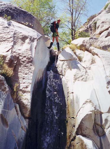
After about 20min of bushwhacking, you will arrive at the top of the first technical section in Cougar Canyon (33o20.49'N 116o30.20'W). This occurs about 1.5hr from the start at an elevation of 3570ft and involves three wet rappels. If you have not done so already this is the place to ensure that your pack is adequately waterproofed since it is likely to get wet. The first rappel uses a midstream tree as anchor and drops 25ft down the streamcourse into an awkward slot pool that requires some agile negotiation. Clambering out of that pool, you continue the rappel down a 10ft drop into another pool. There you should pull the rope and feed it directly into the anchor for the second rappel just a few yards downstream at 3540ft. The anchor for this second rappel is a stout tree by the right wall. This facilitates a vertical 35ft descent into a knee-deep pool where the canyon turns sharp left. The top of the next and highest rappel in this first technical section is only about 60yds downstream and so you can just carry the rope loosely to that point. This third rappel involves a 50ft descent from one of two anchors (either a tree or a well-lodged rock) on a narrow ledge to the left of the lip. It takes you down into a deeply wooded glade that marks the end of the first technical section. You should reach this point (elevation 3400ft) about 3hr 10min from the start.
This also marks the beginning of a long, relatively flat and open stretch of the canyon with some bushwhacking. Beyond this, about 1hr 10min after the last waterfall (4hr 40min from the start) at an elevation of 3250ft, the canyon narrows again and you enter a slot where there are two small rappels from tree anchors. The first is a simple 8ft drop. The second involves several steps with substantial pools in between. A rappel is needed for the first two steps (15ft and 10ft drops). A third, 20ft step is readily downclimbed.
A brief flat section follows before you arrive at the top of a much higher, 50ft vertical rappel. You should reach this 3170ft elevation about 5hr 15min from the start. The anchor is a stout bush growing out of the rock on the right wall. It leads to an awkward rappel down a slot beside a huge boulder below which you should watch for a pendulum underneath the boulder. The descent ends in a large pool where the canyon turns sharp left.
 | 
| |
|---|---|---|
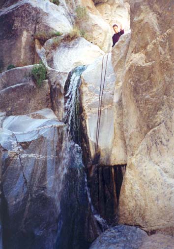
| Second rappel | Rock-walled chasm |
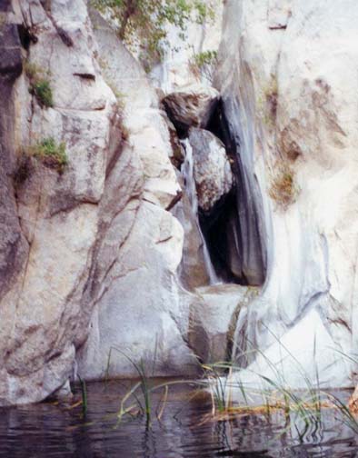
A short distance downstream, 6hr 20min from the start at an elevation of 2950ft, you will arrive at a dramatic ledge where you rappel out of a hanging pool down 30ft into a vertical rock-walled chasm. Here, we were surprised to find the first human artifact since we first left the road, namely an old anchor around a boulder to the right of the hanging pool. Those that installed it must have climbed down from the ridge high overhead. Supplementing that anchor, we descended to a pool and a gravel flat in the bottom of the chasm. A huge boulder almost completely blocks the exit from the chasm, but there is a small gap underneath it (perhaps worn by the stream), through which you can just squeeze. Immediately, you face a chest deep wade through a dark pool. This opens up into the first of the palm groves to be encountered during the descent of Cougar Canyon. Remnants of many fallen palm fronds and trees are strewn all over the canyon bottom and present an unusual obstacle. Just downstream is a great jumble of palm tree debris at the top of an ominous 100ft drop down into a narrow rock-walled hole where the canyon turns left and then right. Alarmingly, it is hard to make out the bottom. However, only two rappels are needed. You first rappel about 30ft from a tree on the left down to a gravel and rock platform in the middle of the watercourse. Then a sling around a large rock anchors a second rappel over a narrow lip and down about 50ft in a wet slot to a small platform. You should continue down another 8ft drop to where the rope can be pulled. Then proceed around the corner and downclimb a short drop to where the canyon opens up again.
This leads to a long, rough section with much bouldering and downclimbing. Here careful navigation is needed to minimize the difficulties. You encounter several more palm groves and, in one place, descend by sliding (carefully!) down a great pile of palm fronds. Then, at 2770ft you arrive at the top of a long and broad sloping rockface where you first downclimb a short way on the right and then use a small tree for a short 15ft rappel before setting up a long 70ft sloping rappel from another, larger tree in mid-canyon. This descent has two steps at the bottom. There follows another section of rough bouldering and downclimbing.
Finally, 9hr from the start at 2470ft, you arrive at the top of the last technical section. From here the end of Cougar Canyon can clearly be seen, still some distance below you. The flat area at its terminus is part of the broad Indian Canyon. The last technical section consists of two rappels. The first is a 60ft drop using a sling around a large midstream boulder as the anchor. Here we noted an old piton and carabinier in the rockface on the left, clearly too old to use. Just downstream you come to the last rappel in Cougar Canyon (33o21.17'N 116o29.29'W). A tree anchor on the right facilitates a 25ft rappel into a small pool leading to a large, deep pool with a chest deep wade.
 | 
| |
|---|---|---|
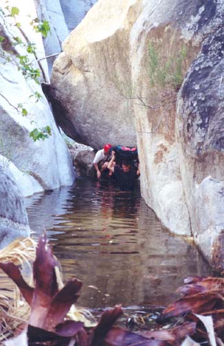
| Chest-deep wade | Last rappel and 2360ft pool |
This pool at about 2360ft marks the end of the line for those ascending Cougar Canyon from the bottom. In his marvellous book "Afoot and Afield in San Diego County", Jerry Schad describes a hike up from Indian Canyon to this pool and we note here Jerry's route down the canyon before describing the shorter but less scenic route we followed. Downstream from the 2360ft pool, a use-trail is clearly evident on the left side of the stream. This leads to a huge cottonwood tree that aids descent down a rocky section. Schad's route then climbs up along the right or south wall to first bypass a feathery cascade of water flowing down a slab of banded rock. It then climbs over a series of rock buttresses and continues along the south wall to avoid a narrow section. Here it passes a deep, shaded pool below a silvery waterfall. Shortly thereafter a huge psychedelic eye can be spotted painted on a rock facing the bench you are travelling along. Just after this you climb down from the bench on the south side and come to a grove of palm trees. From the palm trees proceed down the stream for a way but look for the place where a use-trail climbs about 50ft up the north wall to bypass another section of narrows. This trail comes down to the stream again as the canyon opens up at 1800ft elevation. Downstream of this on a bench overlooking the stream is a rock cave reputedly used as an Indian temescal or sweathouse. Finally, you emerge into Indian Canyon.
However, after the long descent of Cougar Canyon you may wish, like us, to take a shorter but less scenic route out of the canyon. Downstream of the large cottonwood tree we followed a faint use-trail high up the left side of the canyon and clambered over a boulder-strewn shoulder to where we could see into the large gully entering on the left. We then climbed down over the boulders to a palm grove in this gully where we picked up a good use-trail that first descends toward the bottom of Cougar Canyon and then contours along the left wall out of the Canyon to the junction with the trail in Indian Canyon at 1720ft.
Once on the flat bottom of Indian Canyon turn left (north). From here (33o21.47'N 116o28.69'W) a broad and well-travelled trail descends 0.7mi to the Sheep Canyon trailhead (33o21.98'N 116o28.59'W). You should reach this terminus (elevation 1610ft) on the left side of Indian Canyon about 10hr 15min from the start having covered about 4.9mi. From here one dirt road goes left or west to the Sheep Canyon campground. Our route goes in the other direction, due east along the desert floor. Be sure not to take any of the dirt roads going left or north. The correct route tracks along just north of the hills to the south. It is an easy hike along the smooth sandy road to the margins of Santa Catarina Spring where you fork right and then begin a gradual ascent. Here you pass a monument commemorating the passage of the Anza party in 1774 and, shortly thereafter, reach a low, 1410ft pass before descending through the rock-surfaced Boulder Alley to where the return vehicle was parked at 33o22.48'N 116o26.11'W and an elevation of about 1160ft. It is a 3.4mi hike from the Sheep Canyon trailhead to the bottom of Boulder Alley at Third Crossing. You should reach the return vehicle 11hr 30min after the start having covered 8.3mi.
Footnote: The author and his companions would like to express
sincerest thanks for the active help and guidance so generously
given us by Jerry Schad during our adventure in Cougar Canyon.
We recommend his
hiking books very highly indeed.
Last updated 4/30/01.
Christopher E. Brennen