ADVENTURE HIKES AND CANYONEERING
IN THE SOUTHWEST
© Christopher Earls Brennen

|
|---|

|
Hike B6. Cheesebox Canyon
- Hiking time: 6 hours
- Estimated hiking distance: 4.2 miles
- Elevation gain: 360 feet
- USGS Topo Map: The Cheesebox
- Difficulties: Three rappels up to 40ft, many small downclimbs and a cold section of narrow slot swimming
- Special equipment: Rappeling equipment, 120 ft rope, 40 ft webbing, 3 rappel rings, harnesses, helmets and dry bags
-
ACA Rating: 3B III

Characteristics
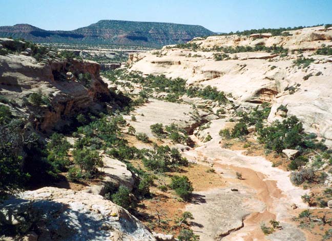
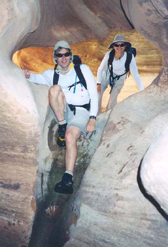
East and north of Lake Powell in the southeast corner of Utah, White Canyon flows through one of the most remote wildernesses in the contiguous United States. It is a land of tortured rock, crenelated and crevassed by the movement of the earth, wind and water and baked dry by the scorching summer sun. But sometimes, summer or winter, the rain comes pouring down, gathers volume as it funnels downhill and creates raging torrents that erode great gullies in the soft sandstone. Cheesebox Canyon is one such gorge that feeds into White Canyon just north of Highway 95. Within its length Cheesebox contains sections of slot canyon just a foot wide, sometimes filled with water that requires you to swim. In other places there are collections of boulders that present route finding challenges and drop-offs that must be rappelled.
This adventure descends a section of Cheesebox Canyon a short distance upstream of the confluence with White Canyon. It is a strenous, all-day adventure that involves swimming deep narrow slot pools that seem buried in the depths of the earth. Since they are far from the sun, the water remains cold even in the summer so a wetsuit is very valuable. Even in the summer (the best time for this adventure) there is a very real danger of flash floods, created by sudden rainstorms and the runoff that funnels down to a torrent in these slot canyons. Do not enter the canyon if there is any sign of rain or of runoff from a recent storm.
Trailhead
A car shuttle is highly desirable on this adventure and cuts 2.9mi of road hiking off the end of the day. Drive to an unmarked junction (37o41.00'N 110o13.24'W) just 200yds north of milepost 67 on highway 95 at a point about 17.5mi south of Hite and Lake Powell or 4.5mi north of the Fry Canyon Lodge in southeastern Utah. The rough dirt road that leaves the north side of the highway here is known as the Cheesebox Road and is the access route for both Cheesebox Canyon and Gravel Canyon. Note that this road can be quite rutted and so a high clearance vehicle is advisable; though it could be travelled with 2WD, a 4WD vehicle is to be preferred.
Just 100yds along Cheesebox Road you will come to a fork where a spur off to the left leads to the graves of two soldiers who were apparently ambushed and killed while in pursuit of some Paiutes. Continuing along the right fork, the road immediately descends into and then climbs out of the other side of White Canyon. It then follows a fairly flat bench off to the northeast, between White Canyon and a prominent redrock cliff known as Found Mesa. From highway 95, drive 7.9mi (30min) to a place where the road crosses a large flat area of slickrock (37o40.38'N 110o5.64'W). Park the return vehicle here and, in the other vehicle(s), continue along Cheesebox Road for another 2.8mi to a nondescript point in the juniper forest (37o42.42'N 110o4.07'W). The precise point does not matter. Park by the side of the road.
Hike
Start by hiking due east through the sparse juniper forest while attempting to follow previously beaten pathways or slickrock in order to avoid excessive damage to the cryptogramic soil. In just a few minutes you will come to the western slickrock rim of Cheesebox Canyon, a broad and impressive vista. The key to the route to the canyon floor is to descend at about 37o42.42'N 110o3.90'W to a ledge just below the rim and then contour around to the left, crossing a drainage in the head of the canyon and accessing the same ledge on the east side of the canyon. The ledge then proceeds south for several hundred yards, crossing through another small canyon and arriving at a large drainage entering from the left. Here, 25min from the start, you descend sloping ledges just beyond the turn into the large drainage and work your way down aiming directly for the confluence of this drainage with the main canyon off to your right. The final step down to the streambed is at the very apex of this confluence (37o42.01'N 110o3.72'W) where you step down some steep slickrock.
 | 
| |
|---|---|---|
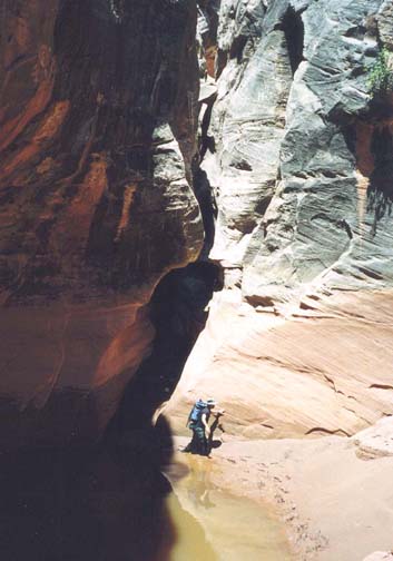
| At the head of Cheesebox Canyon | In a slot near the start |
Here, 30min from the start, you are in the gravel bottom of Cheesebox canyon. Immediately you enter a very narrow slot that is less than 2ft wide in places; you must turn sideways as it snakes back and forth. The floor of this slot is mostly dry. Just after it opens up again, you arrive at a large drop-off with substantial overhang. This is bypassed on the left ledge from which you climb down to the floor where two large drainages meet. This junction leads into a deep and narrow slot.
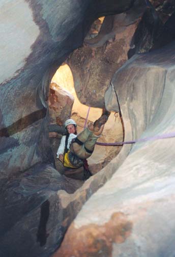
About 30min downcanyon you come to a steep place with a wide shelf on the left. You must downclimb from this shelf into a narrow, convoluted slot with beautiful sculpted narrows that are mostly dry. These lead to the first rappel, a 20ft drop within the narrows that descends into a knee-deep pool. Though the deep wades and swims are still some distance downstream, this is a good place to put on your websuit with your rappelling harness. The anchor for this first rappel (elevation about 5990ft) is a webbing wrap around a small chockstone right at the lip. The convolutions continue in this spectacular section of the canyon and there is one place where the slot is only about a foot wide. The canyon then opens up again and about 40min later at an elevation of 5930ft you come to a wide location where the second rappel descends into a deep, dark slot whose entrance is clogged with boulders. The anchor is a webbing wrap around a large horn boulder right in the slot. On rappel you must squeeze between boulders before the slot opens up and you descend 35ft to a dry, sandy bottom.
 | 
| |
|---|---|---|
| The second rappel | A deep wade and swim |
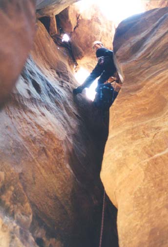
Downstream is a wide water-filled slot that is mostly a chest deep wade though we had to swim the last 10yds. Then, 15min from the second rappel, you come the third rappel into another deep and narrow slot in the middle of a sculpted sandstone floor. Here there is a beautiful natural theatrical stage on the left side with a large thin overhanging roof and fun acoustics. On canyon right is a broad shelf for the audience. We had lunch here accompanied by some impromptu entertainment performed in the natural theater.
The third rappel is almost identical to the second though a little longer, a 40ft drop into a dark and narrow slot. The entrance is a hole between boulders and the anchor is a webbing wrap around a large boulder just upstream of the hole. Again the bottom is usually dry. Downstream is another spectacular, contorted narrows with some small downclimbs and several very narrow places. This slot exits suddenly into a broad, muddy pool that could require swimming.
Here at an elevation of about 5680ft, 3.5hr and about 2.5mi from the start, you come to the junction with a major fork of Cheesebox that enters on the left. Just past this point there are several awkward downclimbs and the canyon becomes dark and narrow. Just ahead is the most physically challenging part of this adventure, the three swimming slots. The first slot begins with a steep, featureless drop of about 6ft into a water-filled slot that requires immediate swimming. A handline around one of the chockstones is useful here. Use a combination of stemming and swimming motions (stwimming?) to progress downstream in this 2-3ft wide slot. Swim around several corners before clambering out onto a rock ledge at water level. There is then another vertical stemming downclimb of about 10ft into the second swimming pool (again a handline is helpful) that is even narrower than the first but shorter. You exit this second swimming pool on a small gravel beach that leads to a short drop into the third swimming pool. At the exit from this last of the three deep and cold slots, the canyon immediately broadens and you should be able to find a sunny spot in which to warm yourself. You should reach this point about 4hr 20min from the start. You could also take off your harness and wetsuit here though there is yet another waist-deep wade to come.
 | 
| |
|---|---|---|
| The third rappel | Slot exit and muddy pool |
There follows a long and lovely section with quite a bit of greenery and much easy hiking. It takes about 50min before you come to the last water, a shallow slot with a waist-deep wade. From other accounts we know this pool can sometimes be very putrid. Once through it you can shed your harness and wetsuit if you have not done so before. You should reach this point about 5hr 20min from the start. Another 20min of easy gravel-floor hiking brings you to the exit point from the canyon. During this time count one short, dry slot that is easily bypassed. When you come to a second, longer dry slot you have reached the start of the exit hike. about 5hr 40min from the start at an elevation of 5600ft.
At this exit point (37o40.32'N 110o5.19'W),
the rock to the right of the slot entrance should be in the form
of inclined slabs. Do not enter the slot but contour and climb gradually
right following a few cairns and hints of a trail. Continue downstream
around a bluff and into a shallow recess where you continue to climb ledges.
Above a prominent ledge, double back toward the right for the last part
of the ascent and climb a steep slickrock drainage up to the rim.
Once over the rim, head directly northwest toward the redrock cliffs.
A few hundred yards of easy hiking should bring you to the large area
of bare slickrock where you parked the return vehicle
(37o40.38'N 110o5.64'W and
elevation 5960ft).
It should take just over 6hr to complete the 4.5mi hike.
Last updated 6/29/03.
Christopher E. Brennen