ADVENTURE HIKES AND CANYONEERING
IN THE SOUTHWEST
© Christopher Earls Brennen

|
|---|

|
Hike G3. Charon Canyon, Death Valley
- Hiking time: 12 hours
- Estimated hiking distance: 7.6 miles
- Elevation gain: 1300 feet
- Topo Maps: Dantes View, Badwater
- Difficulties: 17 rappels up to 140ft, some anchor challenges
- Special equipment: One 300ft rope and two 200ft ropes (though three 200ft would do), 250ft webbing, hammer, 17 rappel rings or quicklinks, rappelling equipment, helmets and leather gloves
-
ACA Rating: 4A IV

Characteristics
Death Valley National Park contains some of the most rugged and fantastic land in the world. That wonderland provides some marvellous adventures and canyoneering experiences. Though the heat in the summer is intolerable, the Park has the advantage that the mild winter weather allows outdoor activity when much of the rest of the southwest is too cold and wintery. This collection contains a number of adventures in Death Valley National Park. Six of them are advanced canyoneering descents in the rugged Black Mountains just south of Badwater on the east side of the valley. Three are labelled on the topo map as Bad Canyon, Hades Canyon and Coffin Canyon. Two others, Styx and Cerberus, are not named on the topo map. This one, which is also unnamed but which we called Charon Canyon, lies between Styx Canyon and Coffin Canyon. It is shorter than the others in terms of horizontal length and so the approach hike is quite long. But it drops dramatically over its short length and therefore involves many rappels. Because of the lengthy approach and the many rappels it is a long and demanding canyoneering adventure similar in technical difficulty to Hades and Cerberus Canyons. As with Styx, the first part of the hike involves accessing the upper reaches of Coffin Canyon. This can be done either as described in the Coffin and Styx Canyon descriptions or, alternatively, by a route starting at Dante's View. The latter is described below; note that this alternative can also be used as alternatives for the Coffin and Styx Canyon descents.
Trailhead
Charon Canyon requires a car shuttle that is best initiated the evening before your descent beginning at a point on Highway 178 roughly 23mi south of Furnace Creek and 5.2mi south of Badwater. This point is immediately north of the alluvial fan of Charon Canyon and just a few yards south of the alluvial fan of Cerberus Canyon. Here you should park and leave your return vehicle by the side of the road at 36o10.36'N 116o45.88'W. It is fairly easy to locate this parking area since it is at the start of the fifth alluvial fan south of Badwater (Bad, Hades, Cerberus, Styx and then Charon).
Then drive 23mi north on Highway 178 toward Furnace Creek; at the junction there turn right onto Highway 190 and drive 9.2mi south where you should turn right following the asphalt road to Dante's View. Follow this for 13mi to the restroom pull-out just below the vista point itself. Park here at 36o13.07'N 116o43.32'W and an elevation of 5160ft.
Hike
From the parking area near the restrooms at 36o13.07'N 116o43.32'W (elevation 5160ft) you should hike toward a low saddle that is several hundred yards away to the WSW (at 36o13.04'N 116o43.53'W). As you reach this saddle veer left up the ridge and hike south along the apex of the ridge to a low summit. From that vantage point you will have an awesome view of the rugged terrain between you and the valley floor. Immediately below you on the right side of the ridge is the left fork of Cerberus. Veer right as you descend the light-colored ridge that drops down from your vantage point. You will see a saddle in this light-colored ridge about 450ft below you; it is a relatively easy hike down along the ridgeline to this second saddle at 36o12.62'N 116o43.60'W and an elevation of 4860ft. From this saddle you need to descend into the shallow gully to left of the ridge and it is easiest to do this by contouring back to your left. Once in the gully bottom, hike down the gully to where another gully comes in from the left at at 4338ft and 36o12.43'N 116o43.52'W about 1.24mi from the start. Turn left and follow that wash upstream and over a saddle at 36o12.49'N 116o43.29'W, 4567ft and 1.45mi from the start. Proceed down the wash on the far side of this saddle. You are now in Coffin Canyon.
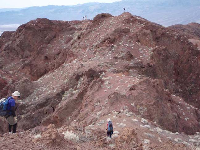
|
|---|
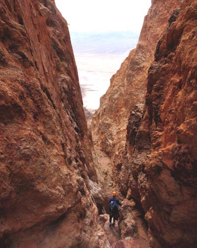
| Ridge hike to Charon Canyon drop-in (Photo by Scott Smith) |
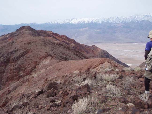
The gravel wash of Coffin Canyon soon becomes broad, flat and fast and you can make quick time over the next 1.5mi to the point 36o11.41'N 116o42.68'W and elevation 3120ft (3.37mi and 1hr 55mins from the start) where you should find a moderate wash coming in on the right. There are several smaller gullies on the right just before this but the one you want is easy gravel travelling. Hike up the wash forking left at a junction and follow the natural runoff all the way up to a point just below Styx Saddle (the saddle is at 36o11.44'N 116o43.01'W and an elevation of 3380ft). Just below the saddle there is an obvious steep ridge leading up to the left that clearly leads to the ridge between Coffin Canyon and Styx Canyon. Follow that ridge to the first high point on the Coffin/Styx Ridge which is at 36o11.30'N 116o43.04'W at an elevation of 3625ft and 3.88mi and 2hrs 35min from the morning start. You should then proceed along the apex of that ridge, surmounting four or five high points but with easy, open hiking. The highest point to be surmounted is near the end of the ridge hike. It is a dark, rocky peak that visible for almost all of the ridge hike and requires some easy climbing. This summit (3532ft) is 5.13mi from the start at 36o10.58'N 116o43.92'W. From that summit you veer right for the descent and then follow the ridge as it curves back to the left passing to the left of a substantial outcropping. At a second small summit note the start of Charon Canyon below you on the left. Descend a short way to the obvious saddle at the head of Charon Canyon at 36o10.46'N 116o44.15'W and an elevation of 3296ft. You should reach this drop-in point 5.44mi and 4hrs 5min from the morning start. It is a good place to rest and prepare for the descent of Charon Canyon.
 | 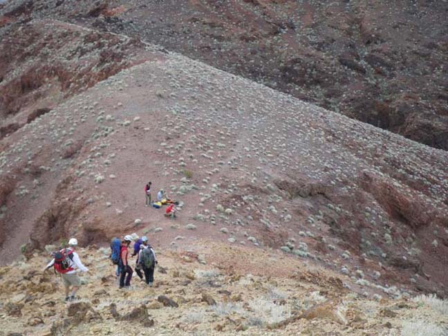
| |
|---|---|---|
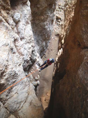
| Ridge hike to Charon Canyon drop-in (Photo by Scott Smith) | Charon Canyon drop-in (Photo by Jeff Cheraz) |
The descent of Charon Canyon begins gently but soon you begin to experience drops; within a few minutes there are small dryfalls at 3190ft and again at 3000ft that can be bypassed on the right or the left. The canyon steepens and about 25min from the drop-in you will encounter the first of two 10ft downclimbs, the first at 2890ft can be descended using a vertical crack in the middle of the dryfall and the second at 2840ft can be downclimbed on the right side. The canyon begins to steepen further and at 2740ft and 4hrs 50min from the start you come to the first rappel, a 30ft drop from a big boulder anchor on the right. This is followed by yet another 10ft downclimb.
Shortly thereafter at an elevation of 2740ft and 5hrs 15min from the morning start you come to the top of a precipitous section of canyon with many rappels. The first is a big 120ft rappel from a boulder anchor on the left. After a subsequent 20ft downclimb, there is a second 120ft rappel down three ledges from a deadman anchor. The last in this series is at 2480ft and involves a 20ft rappel from chockstone anchor.
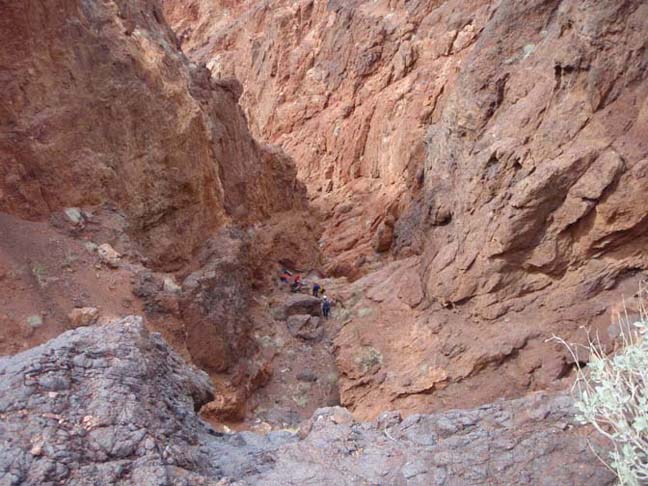 | 
| |
|---|---|---|
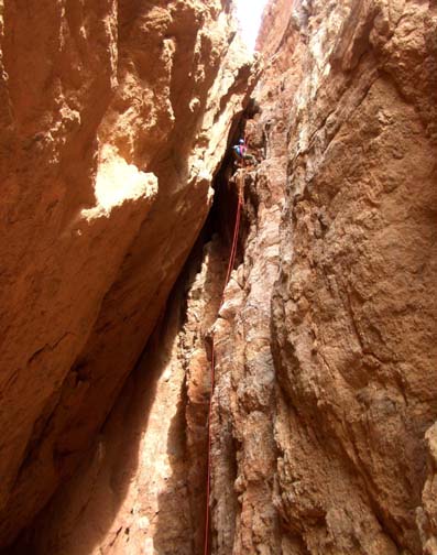
| Upper Charon Canyon rappel (Photo by Scott Smith) | Descending the Charon Canyon slot (Photo by Ira Lewis) |
This series is then followed by a long bouldery section before the canyon begins another precipitous descent. Here the canyon narrows and deepens and you enter the most spectacular part of Charon Canyon. The steep descent begins at an elevation of 2140ft and 6hrs 20min from the start with an 80ft rappel followed by a 20ft rappel from a horn anchor in the canyon floor. The canyon narrows further and at 2000ft elevation you will come to one of the highlights of Charon Canyon, a narrows where trapped boulders have created several false floors above a 100ft high "cave". Climbing down from the first floor you can walk back under it on the lower floor to peer through holes at the 100ft drop. Further descent is by way of a 100ft rappel using a trapped boulder as anchor. A short distance further on, the canyon opens up again and there is another boulder hopping section.
The rappels resume at an elevation of 1510ft (7hrs 30min from the start) with a 20ft rappel from a boulder anchor, followed by a 60ft rappel from a big boulder anchor some distance up the slope on the left. You can then bypass several small drops by contouring across the rock slope on the left and descending again to the canyon bottom at the top of a larger 110ft rappel at an elevation of 1150ft (8hrs 10min from the start); this rappel uses a deadman anchor. This is followed by a boulder downclimb and then by a section of hiking and downclimbing culminating in another series of rappels as the canyon steepens again.
 | 
| |
|---|---|---|
| Charon Canyon slot (Photo by Jeff Cheraz) | The Charon Canyon slot from below |
The first of this series is encountered at an elevation of 950ft
(9hrs 10min from the start) and comprises an 80ft rappel
from a boulder anchor. This is followed by a second 80ft rappel at
550ft, this one from a deadman anchor, soon followed by a larger
130ft rappel, also from a deadman anchor, that descends three large
steps. Immediately below this at an elevation of 340ft
(10hrs 10min from the start) is a 40ft rappel from a deadman anchor
followed by a 25ft rappel from yet another deadman anchor.
Then as you can sense that the canyon exit is close you come at an
elevation of about 100ft (10hrs 55min from the start) to another
narrow section where there is a series of small drops one after another.
These are most readily descended by means of a long rappel though they could
be taken in smaller steps depending on the length of your longest rope.
We used a 300ft rope on a 140ft rappel to descend four of
these steps using a deadman anchor at the top. Several of these steps
had awkward overhangs with potential pendulums. A short distance
downstream is the last rappel, a 25ft drop from a boulder anchor on the
left, and just a short distance beyond this is the exit from Charon Canyon
at 36o10.12'N 116o45.80'W and an elevation
of -100ft. The exit is 7.27mi and 11hrs 40min from
the morning start. You veer right after the exit and hike down the alluvial
fan staying quite close to the steep slope on your right. You should easily
spot your return vehicle on the road at the bottom of the alluvial fan at
36o10.36'N 116o45.88'W and an elevation of
-260ft. It is 7.56mi and about 12hrs since the morning
start.
Last updated 3/10/06.
Christopher E. Brennen