ADVENTURE HIKES AND CANYONEERING
IN THE SOUTHWEST
© Christopher Earls Brennen

|
|---|

|
Hike G5. Cerberus Canyon, Death Valley
- Hiking time: 12.5 hours
- Estimated hiking distance: 4.3 miles
- Elevation gain: 60 feet
- Topo Maps: Dantes View, Badwater
- Difficulties: About 24 rappels, 3 between 150ft and 300ft, some anchor challenges
- Special equipment: 300ft rope, two 200ft ropes, 100ft rope, 300ft webbing, some nuts and pitons, hammer, 25 rappel rings or quicklinks, bolt kit, rappelling equipment, helmets and leather gloves
-
ACA Rating: 4A V

Characteristics
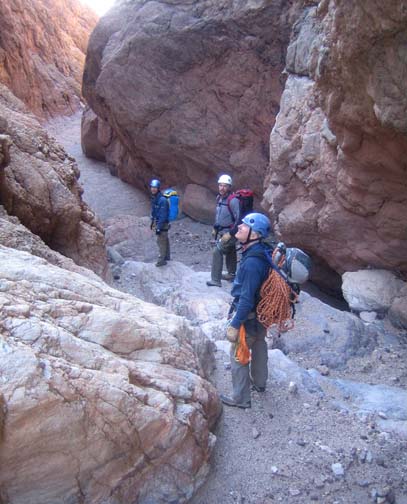
In Greek mythology, Cerberus was the ``hound of Hades'', a monstrous three-headed dog with a snake for a tail and a serpentine mane. He guarded the gate to Hades (the Greek underworld), ensuring that the dead did not leave and the living could not enter. This canyon in the Black Mountains of Death Valley has at least three monstrous drop-offs that will challenge the most experienced canyoneer. It is one of a series (Bad, Hades, Cerberus, Styx, Coffin) that drop almost 6000ft from the spectacular overlook at Dante's View down to the sub-sea-level area near Badwater in the valley floor. Among those five spectacular canyons Cerberus is the most demanding technically because of the number of rappels, the huge drop-offs and the anchor challenges.
The asphalt road to Dante's View ascends the eastern slopes of the Black Mountains and provides a quite dramatic vista overlooking Badwater only 2.5mi away as the crow flies. On a sunny day, the view is otherworldly with the glistening salt in the valley bottom contrasting with the red and gray crags and cliffs of the slopes below you. From Dante's View it seems almost impossible to make that descent. This hike heads due south to access the head of Cerberus Canyon which it then follows all the way to the valley floor. The canyon descent requires about 25 rappels with a number higher than 150ft, one dramatic 250ft vertical drop and one 300ft inclined drop near the end of the canyon. It is an adventure that is only for the very fit and able canyoneer with considerable experience fashioning deadman anchors. Finding and constructing safe anchors is very challenging in this canyon and you should take a variety of technical gear such as hexes, nuts, pitons and hammers as well as a large quantity of webbing.
Most groups will take 12hrs or more to descend Cerberus Canyon though existing anchors may somewhat speed the hike. Nevertheless it is a very long hike and those wishing to complete it in one day should make a very early, pre-dawn start. Like the other Death Valley hikes this is a fall, winter or spring adventure though, in this case, spring days with longer daylight would be best. Whatever the plan, anyone attempting this descent needs to be prepared to rappel in the dark or to face an overnight stop. Note also that there is no water anywhere along the route.
Trailhead
The Cerberus Canyon descent requires a long car shuttle. Perhaps the best base for this adventure is one of the campgrounds at the Park center in Furnace Creek. From there, the evening before the hike, you should drive south to Badwater (17mi away along Highway 178) in two vehicles in order to park the recovery vehicle. From the parking lot at Badwater continue south around three large and obvious alluvial fans, the first deposited by Bad Canyon, the second by Hades Canyon and the third by Cerberus Canyon. Leave the return vehicle on the south side of the Ceberus Canyon fan about 36o11.36'N 116o46.08'W at an elevation of -240ft.
Then, before dawn on the day of your hike, you should drive southeast on Highway 190, climbing gradually along the Furnace Creek Wash between the Amargosa and Funeral Mountains. Ten miles from Furnace Creek, turn right onto Dante's View Road and follow this almost all the way to Dante's View. Though you may choose to park at the view itself, the optimum place for this hike is the sharp right hand turn just before the last switchbacks up to the viewpoint. At this turn there is a turnout with restrooms and adequate room to park. This starting point is at 36o13.07'N 116o43.32'W and an elevation of 4920ft.
Hike
From the parking area near the restrooms at 36o13.07'N 116o43.32'W (elevation 5170ft) you should hike toward a low saddle that is several hundred yards away to the WSW (at 36o13.04'N 116o43.53'W). As you reach this saddle veer left up the ridge and hike south along the apex of the ridge to a low summit. From that vantage point you will have an awesome view of the rugged terrain between you and the valley floor. Immediately below you on the right side of the ridge is the left fork of Cerberus. The right fork, the route of this hike, is less obvious but begins on the left side of the light-colored ridge that drops down from your vantage point. You will see a saddle in this light-colored ridge about 450ft below you; it is a relatively easy hike down along the ridgeline to this second saddle at 36o12.62'N 116o43.60'W and an elevation of 4860ft. From this saddle you need to descend into the shallow gully to left of the ridge and it is easiest to do this by contouring back to your left. Once in the gully bottom, hike down the gully to where it emerges into a broad flat wash. This wash is the right fork of Cerberus Canyon. You should reach this wash at 36o12.43'N 116o43.46'W and an elevation of 4300ft about 45min and 1.4mi after starting the hike.
|
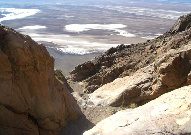
|---|
| Badwater far below Cerberus Canyon |
Hiking down the wash is fast so that after another 30min the canyon narrows and at an elevation of 3950ft you come to the top of a series of rappels in a slot of red, crumbly rock. The first is a 20ft rappel from an anchor in the streambed; this is immediately followed by a 60ft rappel from a horn on the left wall and then by a 70ft rappel from a boulder on the left side of the slot. Then canyon then broadens but short distance later you will come to a much bigger, vertical drop of 140ft that can be rappeled from a boulder anchor on the right. Another short walk brings you to the top of a second 140ft drop at an elevation of 3510ft. Here you rappel down into a broad grotto using a boulder anchor in midcanyon. This second 140ft rappel is immediately followed by a two-step rappel of 30ft plus 20ft from a boulder in the wash. A short hike later there is a 50ft rappel from a midstream boulder before you arrive at the top of the last rappel in this series, a 100ft drop from a big boulder on the left side of the canyon. This last rappel deposits you at the broad and easily recognized junction of the two branches of Cerberus Canyon, the left fork coming in from your right. You should reach this junction at 36o12.19'N 116o44.23'W and an elevation of 3100ft about 4hrs and 2.1mi from the start.
 | 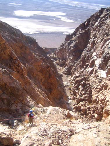
| |
|---|---|---|
| In Cerberus Canyon | 300ft rappel | |
(Photos by Randi Poer) | ||
After the junction the going is easier for a bit though there is a small 20ft downclimb at 2870ft that is quite challenging and then a series of small rappels spread out over the next quarter mile. You will encounter a 15ft rappel from a boulder on the left followed by a small 12ft rappel from a boulder on the right. Then at 2500ft a 15ft rappel from midstream boulder followed a little later by 10ft drop using a horn built into the left wall. A short distance later at 2460ft you will arrive at the top of a 130ft rappel where the anchor possibilities are limited and awkward. There is a large vertical crack on the right side of the lip where we arranged a wedged knot anchor but a nut or hex might also be deployed. As with many of the other rappels in this canyon we used a human belay back-up for all but the last descender. This 130ft drop is almost immediately followed by a 40ft rappel in a narrow slot from a boulder anchor. Then, after a tricky 12ft downclimb in slot on the right side, there is a longish gravel-bottomed section before, at 1880ft, a 20ft rappel from a boulder on the right down onto shelf followed by a 30ft rappel from a deadman anchor in the streambed which brings you to an open, sunny area at a broad left turn. We paused for lunch here at 1750ft roughly 6.5hrs from the start.
Just beyond this lunch spot, the canyon opens up completely and you will arrive at the top of a huge drop-off with a spectacular view of the next section of canyon far below and of the salt flats in the valley even further below. It is a truly awesome sight that all alone is rich reward for your labors in this canyon. The approximate location of the top of this precipice is 36o11.90'N 116o44.98'W. The first steps in this drop-off are two sculpted dryfalls of 40ft and then 100ft. In the interests of time, we choose to bypass these by contouring along high on the right side and then dropping down a gully to the edge of an even more spectacular drop-off where you can look down about 500ft to the canyonbed just a couple of hundred yards downstream. To descend, use the streambed chockstone to rappel about 140ft vertically down to a gravel platform. From here there are two potential routes downstream. One is to follow the main streambed. However, we chose the alternative which is to hike over a low, rocky saddle off to the left of the gravel platform. That leads to a small, steep rocky gully. Descending that gully requires a short 20ft rappel near the bottom using a boulder anchor in the gully; that places you in a steep, broad wash that rejoins the main channel about 300ft below. Fortunately, there are many anchors here and we used a large boulder in the middle of the wash to anchor a 300ft rappel to the canyon bottom. There are several shelves where this rappel could be broken up and where there are boulders to rerig the descent if necessary. You should reach the bottom of this precipitous descent at 1040ft roughly 8hrs from the start.
But the easy gravel canyon bottom that leads away from the bottom of this precipice does not last long. Just a short distance downstream is a small and awkward 20ft rappel down the right side of a huge boulder. This leads to another large drop-off where the easy route is to proceed over a slight rise on the right side to a broad shelf with a couple of large boulders. One of these provides a good anchor for the 100ft rappel down to a short gravel flat. This, in turn, leads to another 100ft two-step rappel (with a large platform in the middle) from a large boulder in the streambed. Then, unexpectedly, you come to the second great drop-off vista in lower Cerberus Canyon where again the canyon opens up and a gaping abyss appears before you. Here at 36o11.71'N 116o45.56'W and an elevation of 610ft you are at the second great drop-off that can be detected from the topo map. You should reach this point 3.6mi and 10hrs from the morning start.
The first step in descending this second precipice is a 240ft vertical rappel from a reassuringly large boulder/outcropping in midcanyon just a little back from the lip. The fall line of this rappel eventually leads to a narrow projecting ridge jutting out from the main wall. The rappeler should aim to veer to the canyon right of this projection where the floor is maybe 20ft higher than to the left. This rappel leads to a gravel bottom followed by a small downclimb before you arrive at the top of the another large two-step drop that takes some careful planning. The first step is a 60ft rappel from a boulder anchor some distance back from the lip. This is readily accomplished but it places you on a narrow, recessed slot shelf with very few anchor possibilities. We used a deadman anchor against the left wall to rappel down the second 120ft step but perhaps this is one place where bolts or pitons are needed. After this only one rappel remains, a straighforward 50ft drop from a convenient large boulder at the lip. This places you in the wash within about a hundred yards of the canyon exit at 36o11.71'N 116o45.80'W, 3.8mi from the start at an elevation of about -100ft.
From the exit it is simplest to follow the streambed down the alluvial
fan in a southwesterly direction to reach your vehicle parked on the
Badwater Road (it should have been visible since you arrived at the top
of the first great drop-off).
The vehicle should be at 36o11.36'N 116o46.08'W
and an elevation of -240ft. It should take about 12hrs to
complete the hike which is 4.3mi long.
Last updated 1/10/07.
Christopher E. Brennen