ADVENTURE HIKES AND CANYONEERING
IN THE SOUTHWEST
© Christopher Earls Brennen

|
|---|

|
Hike H5. Cathedral Peak
- Hiking time: 7.5 hours
- Estimated hiking distance: 5.5 miles
- Elevation gain: 2350 feet
- USGS Topo Map: Tenaya Lake
- Difficulties: Class 3 climbing with substantial exposure; a 15ft section of class 4 climbing to get to the top of the summit block
- Special equipment (for the summit block climb): Harnesses, rope, rappelling gear, webbing and belay equipment
-
ACA Rating: 3A III

Characteristics
This spectacular adventure takes you through one of the most scenic places in the world and provides a beautiful cross-section of the magnificent high country in Yosemite National Park. It climbs from Tuolumne Meadows up through the forest alongside Budd Creek to the base of the towering Cathedral Peak. It then climbs that glorious pinnacle, an ascent that requires only class 3 climbing until the very last phase that is class 4. Thus no special equipment or experience is needed except for the final phase, though the climbing is demanding and, in places, the exposure is frightening. The last, 15ft climb to the top of the summit block does require technical equipment and expertize; at least one member of the party should be experienced enough to lead climb that last phase and safely belay others to the top.
This is the land that John Muir explored during the summer of 1869. His account entitled ``My First Summer in the Sierra'' did much to bring the beauty of these mountains to the attention of the world. Part of this hike follows (in reverse) the route he took on the way from the valley to Mono Pass. On the way he took particular note of Cathedral Peak:
``...the wonderful mountain called Cathedral Peak is in sight.
From every point of view it shows marked individuality. It
is a majestic temple of one stone, hewn from living rock,
and adorned with spires and pinnacles in regular cathedral
style. The dwarf pines on the roof look like mosses. I hope
some time to climb it to say my prayers and hear the stone
sermons.''
Later in his narrative he comments
``I never weary gazing at the wonderful Cathedral. It has
more individual character than any other rock or mountain
I ever saw, excepting perhaps the Yosemite South Dome.''
As his sojourn in Tuolumne Meadows was growing to a close at the end of his summer, it is clear that the urge to climb Cathedral Peak became overwhelming and so on September 7, 1869, John Muir left his Tuolumne Meadows camp at daybreak determined to get to the top. The first part of the present adventure follows the approach he took to the peak. Presumably he also followed roughly the same route to the summit, though he gives no detail. There is no doubt however that the experience affected him deeply:
``No feature, however, of all the noble landscape as seen
from here seems more wondeful than the Cathedral itself, a
temple displaying Nature's best masonry and sermons in
stones. How often have I gazed at it from the tops of hills
and ridges, and through openings in the forests on my many
short excursions, devoutly wondering, admiring, longing!
This I may say is the first time I have been at church in
California, led here at last, every door graciously opened
for the poor lonely worshiper.''
And he continues at some length in this vein. Whether he actually climbed to the top of the summit block is unclear but he is given credit for the first ascent.
In the second phase of this adventure, you descend to the magnificent Lower Cathedral Lake where all will pause to enjoy the bucolic beauty of the lake and the country around it. The contrast with the rugged grandeur of Cathedral Peak towering high overhead is especially delightful. The hike then descends the huge rock slabs by which the stream from Lower Cathedral Lake descends to Tenaya Lake. This involves some careful navigation to negotiate one large drop-off that interrupts the otherwise gradual descent over the bare rock.
This marvellous adventure is best for the late summer.
Trailhead
Though there are clearly alternative routes, some of which would allow you to end where you started, the hike described here is a one way adventure that requires a short car shuttle along the Tioga Road in Yosemite National Park. As you are driving away from Tenaya Lake in a northeasterly direction toward Tuolumne Meadows there is a prominent rock dome on the right called Pywiack Dome. Park one vehicle at the side of Tioga Road about 0.5mi northeast of Tenaya Lake and about 400yds southwest of that dome (37o50.57'N 119o26.87'W). Then, in the other vehicle, drive the six or so miles to Tuolumne Meadows and park at the well-used Cathedral Lakes trailhead (37o52.40'N 119o22.97'W) on the south side of the meadows. There are bear boxes on the south side of the road beside the trailhead and you would be advised to use them, leaving no food in your vehicle.
Hike
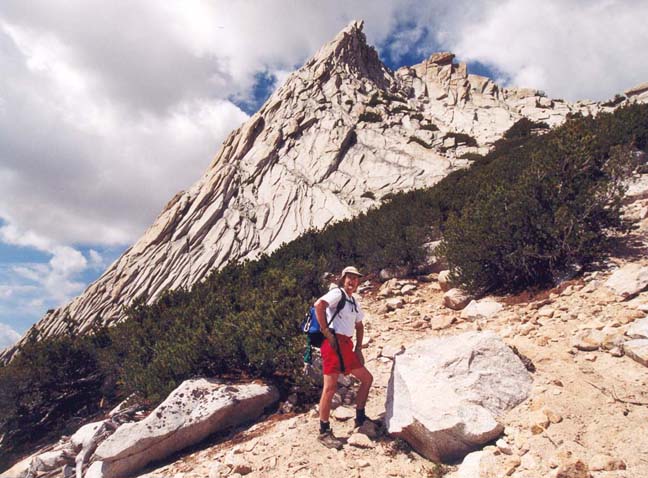
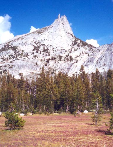
The hike begins at the Cathedral Lakes trailhead (37o52.40'N 119o22.97'W and elevation 8560ft) on the Tioga Road just west of the Tuolumne Meadows Ranger Station. Follow the well-used Cathedral Lakes trail for only about 100ft and then bear left to follow the right bank of Budd Creek. The use-trail alongside Budd Creek may initially be faint but soon becomes easy to follow. It climbs the sparsely tree-covered slope to the right of the shallow gully cut by Budd Creek, sometimes crossing rock slabs. Eventually, about 1.5mi from the start, the trail crosses the creek and you follow the left bank for a short distance as Cathedral Peak becomes increasingly visible above the trees to the west. Soon, about 1.7mi and 1.5hr from the start, the gully opens up into a broad grassy clearing at about 9600ft. From here you get an unobstructed view of the peak and the slope you must climb to approach it.
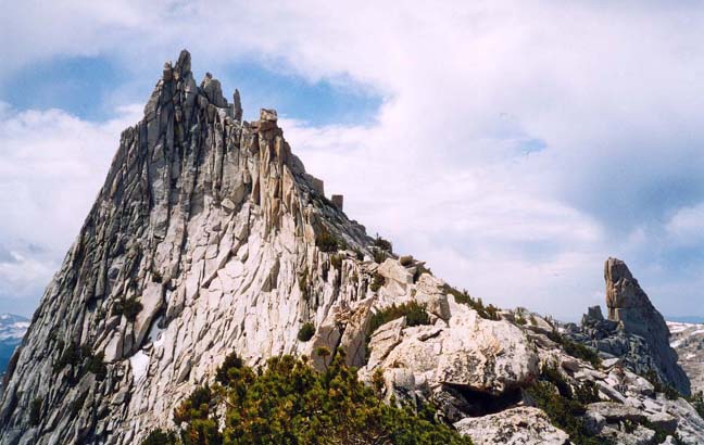 | 
| |
|---|---|---|
| Cathedral Peak and Eichorn Pinnacle | On climb to saddle (Photo by Clancy Rowley) |
Pause here at the lower, north end of the clearing to memorize the topography to your west. The dramatic rock pinnacle that is Cathedral Peak is readily recognized. Its left side is a steep rock slab known as the Southeast Buttress, a favorite rock-climbing route to the top. To the right or north side of the Peak is a saddle that is the next destination. Once the topography is clear in your mind, leave the trail, and head almost due west for the talus slope leading to the saddle. As we headed up through the thin forest on the west side of Budd Creek we soon picked up a few ducks and then a use-trail climbing the steep, rocky slope leading to the saddle. Along this way there are spectacular views of the summit high above you on the left. And, chances are, you will see climbers ascending the Southeast Buttress along a path that seems to parallel yours. Nearing the saddle the boulders get huge and soon you are on the saddle itself. The view to the west that opens up as you broach the saddle is spectacular with the dramatic Eichorn Pinnacle over to your left and Lower Cathedral Lake far below it. You should reach this 10700ft elevation about 3hr from the start.
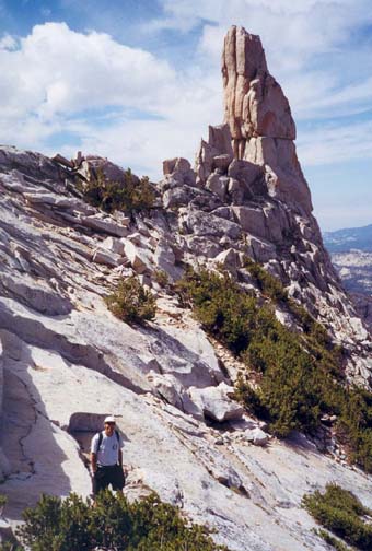 | 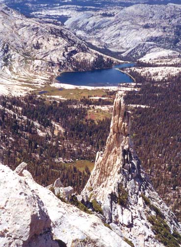
| |
|---|---|---|
| Eichorn Pinnacle from first saddle | View west from summit of Eichorn |
Having enjoyed the view, you should climb down over massive boulders on the other side of the saddle to a point about 30ft lower where you can see a straightforward traverse over to the lowpoint or saddle in the ridge connecting the peak with Eichorn Pinnacle. Climbing up some boulders to this second saddle you are treated to yet another great view, this time to the south. Upper Cathedral Lake lies below you and, off to the southwest, are Half Dome and the other monuments of Yosemite National Park. The sheer south face of the mountain drops down vertically below you, a drop of about 300ft before the ground flattens out. (To me it appeared that there were some ledges with natural anchors that could well allow one to rappel down this south face.) From the second saddle you then begin the ascent along the ridge leading to the summit. The obvious route is just to the left of the ridgeline and involves class 3 climbing over large boulders and rockslabs that have good friction and lots of handholds. As you approach the summit you bear left onto a series of broad ledges that lie below the summit ridge. The summit block itself is the left most of the three pinnacles that loom high overhead but it is not visible until near the end of the ascent up the ridge. However, when you clamber up onto the left end of the topmost ledge, the summit block is readily identified and there is an easily ascended slot just to the right of the summit block that leads to the last, and most difficult phase of the ascent. You should reach this point about 3.5hrs from the trailhead.
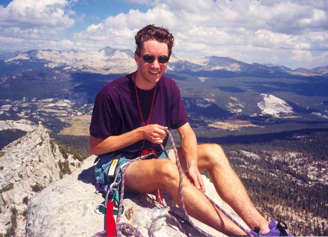
You should pause in the safety of this slot to prepare your climbing equipment, to buckle on your climbing harnesses and to plan for the 15ft class 4 climb to the top. There are several large boulders at the top of the slot where you can prepare to belay the lead climber. That person will experience dramatic exposure of nearly 1000ft when they step out of the top of the slot to climb to the summit, so it is important to prepare a secure belay. From the top of the slot, the climber should traverse across the south face about 15ft using two horizontal cracks, one for hands and the other for feet. This leads to a shallow recess with two vertical cracks leading 15ft up to the summit. These two cracks provide good holds for the class 4 climb to the top. The summit surface is a flat platform that is only about 4ft by 6ft in size and can only comfortably hold four or five people at most. There used to be bolts at the top to belay the rest of the group to the top and to use for a rappel descent from the summit block. Unfortunately, someone chopped these bolts and so, unless they have been replaced, it is necessary to climb down the way you came up.
|
|---|
| Clancy on summit (Photo by Don Caldwell) |
Once we reached the talus slope we descended northwest and then west, down the steep, rocky slope heading for an intersection with the Cathedral Lakes Trail that was visible below us. We were careful not to descend directly west from the end of the rappels for that would have led to some very steep rock slabs. On the route we did take, the footing for the descent was easier than we experienced during the ascent on the other side of the mountain. There are several sections where you must find a way down or around short rock slabs but this is fairly readily done. As you approach the bottom, you enter the forest and must bear due west to intersect the well-travelled Cathedral Lakes trail at an elevation of about 9500ft. You should reach the trail about 6hr 15min from the start.
From here head due south on the Cathedral Lakes trail to where it forks (37o50.93'N 119o24.93'W) and take the right fork down to the glorious Lower Cathedral Lake (elevation 9250ft). Take the use-trail around the north shore to the outlet from the lake but pause along the way to soak up the beauty and grandeur of this magnificent place. On a still day the water of the lake will reflect the shining white rock of Cathedral Peak soaring above the lake and contrasting with dark green of the pine forest and the light green of the meadows surrounding the lake. And glittering here and there are the bright colors of the mountain flowers, sparkling in the California sun. After the rugged grandeur and excitement of the Peak, this is a very special moment indeed.
 | 
| |
|---|---|---|
| Cathedral Peak from Lower Cathedral Lake meadow | View down west of Lower Cathedral Lake |
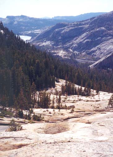
At the far west side of the lake (37o50.77'N 119o25.69'W), it is simple to find the outlet that immediately flows over a broad rock ridge and down a wide and bare rock slab. Here another great vista opens up. In the distance you can see a corner of Tenaya Lake. The dogleg route taken by Cathedral Creek on its way from where you are standing down to Tenaya Lake is clearly evident and, with sharp eyes, you should be able to discern your vehicle parked along the Tioga Road. You can descend the first part of the rock slab on either the left or right side of the stream. However, about 2/3 of the way down there is a steep, almost vertical drop-off that extends all the way across the face. Though there are several ducks on the right hand side it is dangerously steep there. Consequently, you should traverse over to the left at the top of the step and follow the top a short way into the forest. There the drop-off peters out and you can make an easy descent and return to the rock slab for the remainder of the way down. At the bottom, the streambed makes an abrupt left turn (37o50.81'N 119o26.20'W) and wanders through deep forest for a short way. Soon you can see that you can make easier progress on the right bank. Contouring right you access a broad, slightly sloping rock slab that you descend to the right of the stream. The dome on your right here is Pywiack Dome (explored and described by John Muir in his book) and the Tioga Road runs along the far side of that prominence. At the base of the rock slab, follow the streambed again for a short time before the woods on the right open up. Then veer right through the woods, contouring around the south end of Pywiack Dome where you should pick up a use trail. As the noise of the traffic on the Tioga Road becomes clearer, you should veer west to intersect it and, hopefully, emerge on the road not too far from your parked vehicle (37o50.57'N 119o26.87'W). The final elevation is about 8200ft and the total time for the hike is about 7.5hr.
Alternative Return
After summitting you may wish to return directly to the Tuolumne Meadows trailhead. If so, an interesting and quick return route is to climb down the way you came to the saddle between the peak and the Eichorn Pinnacle and then to rappel down the steep south side of the mountain. This descent requires a two stage rappel. From a webbing wrap around one of the large boulders at the saddle (in the shadow of the Eichorn Pinnacle) first rappel down about 60ft to a large shelf with two substantial trees. One of these provides a solid anchor for the second stage, a 150ft drop using a 50m rope and a recovery cord.
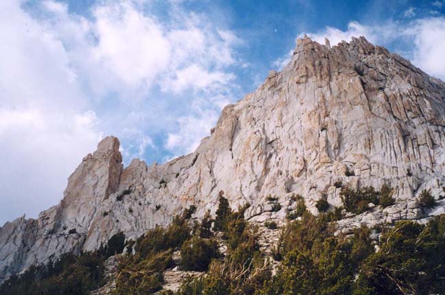
|
|---|
| Southern aspect of Cathedral Peak |
The two-stage rappel places you at the top of a short scree slope. If you
descend this and veer left at the bottom it is an easy hike around the mountain
to the use-trail you used to hike up to the mountain beside Budd Creek.
Last updated 9/1/00.
Christopher E. Brennen