ADVENTURE HIKES AND CANYONEERING
IN THE SOUTHWEST
© Christopher Earls Brennen

|
|---|

|
Hike K26. Carrizo Gorge
- Biking time: 5 hours
- Estimated biking distance: 22 miles
- Elevation gain: None
- USGS Topo Maps: Jacumba, Sweeney Pass, In-ko-pah Gorge
- Difficulties: Bike riding through dark tunnels
- Special equipment: Headlamps and spare inner tubes
-
ACA Rating: 1A III

Characteristics
During the great era of railways in the early part of the 20th century, each city on the western seaboard of the North American continent needed a fast and reliable supply line from the east to ensure growth and prosperity. San Diego was no exception and its promoters decided that it would be wise to supplement the supply line from its larger, northern neighbour, Los Angeles, by a more direct line to the east. Such a route would access the Imperial Valley on the other side of the coastal mountains and proceed on to Arizona. And so was born the San Diego and Arizona Railroad. Construction began eastwards from San Diego, ventured south into the Mexican border towns of Tijuana and Tecate, crossed back into the US and climbed into the mountains to a summit of about 2800ft near the border hamlet of Jacumba, California. Here the railroad engineers faced a major challenge for the land to the east dropped sharply down a steep escarpment to the floor of the Imperial Valley. The present day highway descends from 3200ft about a mile east of Jacumba to 400ft in Ocotillo over a distance of about 12mi, a grade beyond the capablity of a railroad. The only route that seemed possible was to build the railroad high along the wall of the steep Carrizo Gorge and thus descend more gradually to Ocotillo and the floor of the Imperial Valley. But this contour down through the canyon presented a massive engineering challenge for it required the digging of numerous tunnels (17 in all ranging in length from 290ft to half a mile) and the building of many trestles in order to cross the numerous lateral ridges and canyons. Thus it became known as the ``impossible railroad'', a name made more apt by the hostile desert terrain and climate, with temperatures in the summer soaring to over 110 degrees Fahrenheit. But the railroad was built, the final spike being driven by owner John D. Spreckels on Nov.15, 1919.
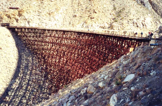
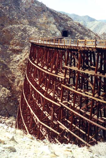
Maintaining the Carrizo Gorge section with its numerous tunnels and trestles was a constant challenge, especially in this earthquake-prone country close to the monstrous San Andreas fault. When an earthquake collapsed one of the tunnels in 1932, the engineers chose an alternate route around the ridge which that tunnel had negotiated. But the alternate route necessitated the construction of a bridge over a steep lateral gorge known as Goat Canyon. The wooden edifice they constructed was the highest, curved trestle in the United States, a spectacular structure over 600ft long and 180ft high in the center. That trestle still survives and represents one of the highlights of this adventure.
Though the last passenger train to travel the full length of the railroad left San Diego on Jan.11, 1951, the railroad continued to ferry freight through the Carrizo Gorge until September 1976 when tropical storm Kathleen dumped nearly 10in of rain on the area in a very brief period and washed out the impossible railroad in numerous places. The damage to the section through Carrizo Gorge was so massive that it remains closed to this day. And that provides the opportunity for this adventure in which we follow the rails all the way from the high point in Jacumba down the gradient to Ocotillo. It is a spectacular journey of about 22mi through a stark desert landscape, dotted with the efforts of railroad engineers to tame this wilderness, an effort that came to nought. While it is possible to hike to the Goat Canyon Trestle from either the top or the bottom, the best way to experience this adventure is to ride mountain bikes down the length of the gorge. Clearly this is an adventure that is best for the winter months from November to March. I recommend that, as well as lots of water, you take several spare inner tubes and a headlamp to find your way through the tunnels.
Trailhead
Drive east from San Diego on Interstate 8 for about 90mi to the Jacumba off-ramp. There are gas stations at the end of the off-ramp in case you need some last minute supplies. Then drive back west along a dirt road that runs parallel to and south of the freeway. Just 1.3mi from the gas stations, the dirt road goes under the freeway alongside the railway. This is the easiest place to park (32o38.77'N 116o11.16'W) and the easiest place to access the route along the tracks.
To place a return vehicle at the bottom, continue east on Interstate 8 for about 16mi, descending the escarpment down to the floor of the Imperial Valley at the small settlement of Ocotillo. As you come to the valley floor take note of a small but prominent flattop hill to your north. This is called Sugarloaf Mountain and serves as a valuable navigational aid when traversing this area later. The railway passes between Sugarloaf and the freeway. Just east of Sugarloaf you pass the Route 98 off-ramp and then leave the freeway at the Ocotillo exit. Cross under the freeway to the north side, drive through the village of Ocotillo continuing north on route S2. Beyond the village, 0.8mi from the freeway, S2 turns west; continue on this road for about 2.5mi (3.3mi from the freeway) to where the power lines cross the road.
At this point, it is important to emphasize that there are several options for parking the return vehicle, and therefore several options for the last part of the bike trip. Perhaps the best option is to park the car by the side of route S2 just under the power line pylons (32o45.23'N 116o2.94'W). The advantage of this location is that it is readily found if you take a wrong turn on the dirt roads over the last part of the bike trip. However, if you arrive here early enough in the day and you have four-wheel drive vehicles, you may wish to shorten the bike ride by trying to locate the trailhead closest to the gorge.
Here are the directions for that objective. From the starting point where the power lines cross S2, drive south on the dirt road paralleling the wires for about 1mi and turn right at 32o44.18'N 116o3.30'W to bypass Sugarloaf to the right. The dirt road then turns west and you proceed up the gently rising floodplain. The railway will become increasingly visible on your left. About 4.4mi from Sugarloaf the dirt road starts paralleling the tracks and a wooden water tower alongside the railway should come into view. This tower marks the location of an abandoned engine servicing point called Dos Cabezas, that is 7mi from the highway. Dos Cabezas (32o44.80'N 116o8.42'W) is also an excellent place to park your return vehicle. However, if you wish, you can drive another 2.4mi up the dirt road (better surface here than earlier) to the limit of vehicular traffic where there is a makeshift trailhead and parking lot (32o45.92'N 116o9.95'W). The railway line is just about 50yds up to the left of the parking area. Note also that this would be the starting point for an out-and-back hike to the Goat Canyon Trestle.
Wherever you decide to deposit the return vehicle for the bike ride, you must then retrace your steps to Interstate 8, drive back west to the Jacumba exit and then park your vehicle in the freeway underpass as described above (32o38.77'N 116o11.16'W).
Bike Ride
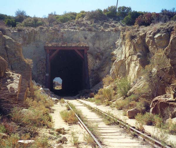
From the freeway underpass (32o38.77'N 116o11.16'W and elevation 2720ft) proceed north along the railroad tracks. For most of the ride, the best route is to the left of the tracks and this is true right from the beginning though the going is a little rough initially. Just north of the freeway you pass a nudist camp to the east of the railway but, very soon, you are in the desert wilderness with little sign of civilization other than the railway. Old signs warn you against trespassing and about blasting but these seem abandoned. After a little less than a mile, the Carrizo Gorge begins to form on the left. This is a lovely desert landscape with a wide variety of cacti many of which will be in bloom if you choose to come in the spring. After just 1.4mi you arrive at the first tunnel, a short one with the same marvellous wooden vaulting that characterizes most of the tunnels. Beyond this the Carrizo Gorge begins to deepen dramatically and, after another short tunnel, you arrive 45min and 3.8mi from the start at the entrance to the first long tunnel. Before you turn your attention to that obstacle, you probably missed seeing two ruined boxcars lying well below the railbed just a few hundred yards behind you. Don't try to climb down to them. There are more accessible boxcar wrecks further on.
|
|---|
| The first small tunnel |
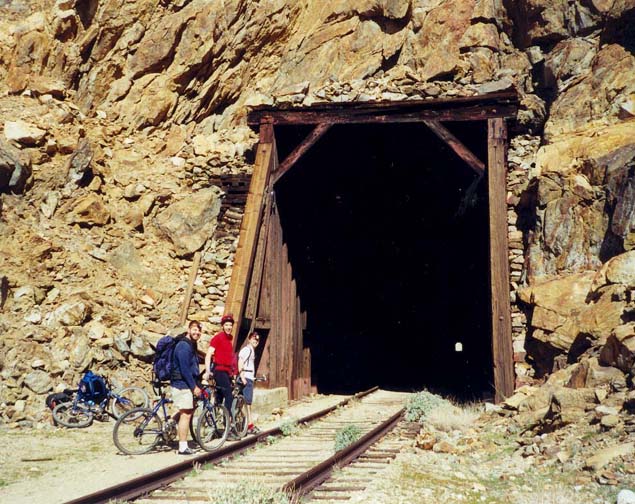
The first big tunnel is about 0.5mi long and, unlike, the other tunnels is equipped with a concrete-lined entrance and huge iron-barred doors. On the doors someone has written a message warning of deep water and a blocked tunnel, a message we failed to see. Thus we proceeded into the increasing darkness with no sign of daylight ahead and, after about 0.4mi, found ourselves wading through waist-deep water before we realized that the tunnel seemed totally blocked ahead and had to retreat. Thus, unless you wish to explore the darkness, you should follow the alternate route to the left of the entrance, an obvious use-trail that contours around the ridge this tunnel penetrates. Along the way you can look back and see the afore-mentioned boxcars. It is a little more than a mile before the trail returns to the railroad tracks at the other end of the blocked tunnel, a point you should reach about 1hr 10min from the start. There you can plainly see the rockslides that block the north end of the tunnel.
 | 
| |
|---|---|---|
| The open half-mile tunnel with light at the end | Tank car at the Goat Canyon Trestle |
Resuming the ride along the railway, you pass through a pair of tunnels separated by a short airspace. Three more short tunnels follow at intervals. Then, about 1hr 40min and 6mi from the start, you arrive at the entrance to the second big half-mile-long tunnel. It is reassuring to see daylight at the other end though that makes the tunnel seem shorter than in fact it is. Fortunately the pathway to the left of the tracks is quite free of major obstacles. Emerging from the darkness at the other end it is not far to the short tunnel that immediately precedes the Goat Canyon trestle.
 | 
| |
|---|---|---|
| The Goat Canyon Trestle from the north | The Goat Canyon Trestle |
You should reach the Goat Canyon trestle (32o43.75'N 116o11.03'W and railbed elevation 2360ft) about 6.8mi and 2hr into the bike ride. It is a spectacular structure whose curve gives it a special grace. Be sure to take some photographs from the southern end even though the other end has better photo opportunities. As with all the other trestles, you cross by walking or riding on the 3ft wide metal gratings beside the tracks. These gratings are safe though they might catch the tires of a regular bicycle and it is better to walk rather than ride. They are quite open and so the drop you see when you look down can be quite disconcerting.
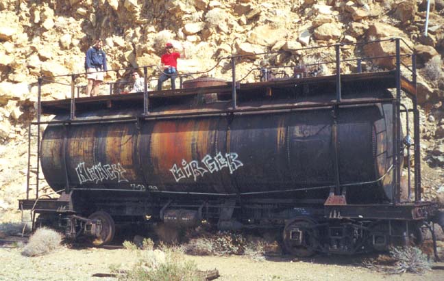
On the other side of the trestle there is a spur with a tank car that was placed here to provide water in case the wooden trestle caught on fire. But the spur is interesting for another reason. It was the original route of the railway and led to a much longer tunnel in the ridge to the south. That tunnel was severely damaged in the 1932 earthquake. Indeed the crazy inclination of the surviving old tunnel entrance provides a mute testament to the power of that earthquake. The new route required the constuction of the Goat Canyon trestle. Other railroad remnants survive including an old-style railroad signal for the spur switch. We lunched atop the tank car from which vantage point the view of the trestle is particularly good.
Moving on down the line, the next tunnel has collapsed so you need to take another ridge-contouring trail that provides excellent views in both directions. Returning to the railbed you then proceed through a series of small tunnels interspersed with trestles as you contour down the side of Carrizo Gorge. Then, 2hr 30min riding time and 9mi from the start, you should look for two Southern Pacific boxcars that somehow got over the side and lie wrecked about 50ft below the railbed. These are the ones to climb down to if you so desire.
About a mile further on the railway leaves Carrizo Gorge through a
tunnel that leads to a smaller, lateral canyon. The section beyond that
tunnel is quite scenic with sculptured mounds of orange rock. Two other
small tunnels here have attractive entrances. And if you look down
into the canyon bottom you will see two groves of palm trees, both
labelled Carrizo Grove on the topo map.
Then, 11.7mi from the start, the railway makes a 90-degree turn
and heads southeast as it transitions from the canyon region onto the
much flatter sedimentary terrain over which it travels to the floor
of the Imperial Valley.
About a mile further on, 12.9mi and 3.5hr of riding time
from the start, you will come to the parking area at the limit of vehicle
travel up the route of the railway
(32o45.92'N 116o9.95'W and
elevation 1940ft).
Here it is easier to leave the railway and ride
down the good dirt road that parallels the tracks.
It takes just 20min to ride down the road to Dos Cabezas
(32o44.80'N 116o8.42'W), a train
servicing station with a surviving wooden water tank at an
elevation of 1740ft. Several
dirt roads emanate from Dos Cabezas but you want the one that
continues to run parallel (and north of) the tracks. As you
descend along the next mile try to identify Sugarloaf
Mountain which should be almost straight ahead. The surface of the
road gradually gets worse with stretches of deeper sand and of
washboarding. Moreover, the road veers off to the left of the
tracks at one point though the railway comes back to the road as you
continue to progress southeast toward Sugarloaf. This is a long
and challenging part of the ride. However, about 5.3mi from
Dos Cabezas you should come to a dirt road fork (elevation 860ft)
just to the left and north of Sugarloaf
(32o44.18'N 116o3.30'W).
From here you should be able to discern
the pylons and power lines running north/south across the path
in front of you. Go left at the fork and this will lead to the road running
parallel to the power lines. One mile north beside the pylons will
bring you to Highway S2 and your return vehicle
(32o45.23'N 116o2.94'W).
It is 6.5mi from
Dos Cabezas to the Highway and you should reach this point, 22mi
from the start, after about 5hr of riding. The entire adventure
can be accomplished quite easily in a day provided you get an early start.
Last updated 2/10/01.
Christopher E. Brennen