ADVENTURE HIKES AND CANYONEERING
IN THE SOUTHWEST
© Christopher Earls Brennen

|
|---|

|
Hike E1. Buckskin Gulch
- Hiking time: 9.5 hours
- Estimated hiking distance: 20 miles
- Elevation gain: 220 feet
- USGS Topo Maps: Pine Hollow Canyon, Bridger Point, West Clark Bench
- Difficulties: Some thigh-high wading and one 12ft downclimb
- Special equipment: A walking staff and 30ft rope or webbing
-
ACA Rating: 2B V

Characteristics
In northern Arizona and southern Utah there is a vast area of rugged high desert that is mostly uninhabited wilderness. It is a rugged and parched landscape of desert and mountains where thunderstorms bring deluges of rain that tear the land apart and gouge deep and narrow gullies in the soft Navajo sandstone. These slot canyons, sometimes thousands of feet deep and yet only a few feet wide, are a ubiquitous feature of this landscape and journeys through them in Zion National Park and elsewhere are described in other chapters of this journal. One of the longest, deepest and yet technically easiest of these slot canyons is known as Buckskin Gulch. It lies along the Arizona/Utah border about midway between the communities of Page, Arizona and Kanab, Utah, and is part of the Paria Canyon - Vermillion Cliffs Wilderness Area managed by the Bureau of Land Management (BLM). This adventure takes you down the entire length of Buckskin Gulch and back out along the canyon of the Paria River. Though very long (just over 20mi), this hike is easier than might be envisaged due to the mostly excellent and easy footing in the canyon bottom. During much of the recommended season, the only difficulties are maybe a dozen thigh deep pools that must be waded and one 12ft downclimb caused by a boulder jam. Many of the hikers that tackle this route do it as an overnight adventure. However, in my judgement, it is more enjoyable to travel light and thus faster. Most experienced hikers will easily complete it in a day provided they get an early start.
As in all slot canyons, flash floods pose a lethal danger. Consequently it is very important to gauge the flash flood potential before beginning this hike. In addition to listening to the local weather forecast, before setting out you should check at the BLM Paria Ranger Station (between mile markers 20 and 21 on US89) for the flash flood danger and for other conditions in the Gulch.
This adventure requires hot weather on the land above the canyon for it can be 15 degrees cooler in the depths of the slot. But you should also avoid the thunderstorm season in late July, August and early September. Consequently, the best time of year for this hike is in May or June after the slot dries out and before thunderstorm season. Note, in contrast. that there is very little water in the Gulch and that you should plan to carry all the water you will need, say four quarts for the day hike.
Permits: If you tackle this adventure as a dayhike you will not need to obtain a permit ahead of time; it will only be necessary to purchase a parking permit at the Wire Pass Trailhead as you start your hike. However, if you decide to overnight, you will need to obtain a wilderness permit from the BLM. Information on permits can be found at the website http://paria.az.blm.gov or at the BLM Paria Ranger Station.
Trailheads
Buckskin Gulch lies just south of US Highway 89 between the cities of Page, Arizona, and Kanab, Utah. The hike described here requires a car shuttle, set up by turning south off US89 just east of mile marker 21 (and just east of a bridge over the Paria River) about 30mi from Page and 44mi from Kanab. The Ranger Station is not open all the time but, if it is open, stop and check on the conditions in Buckskin Gulch and on the weather forecast. Then continue south on the dirt road to the White House trailhead (37o4.72'N 111o53.40'W and elevation 4320ft), approximately 2mi from the highway. Leave the return vehicle in the parking area and, for later purposes, take note of the landscape of the wide Paria River wash south of the trailhead.
Then drive back to the highway, and proceed west for 4mi, up a steep grade and through a large cutting where the road turns right. The dirt road you seek leaves the highway on the left just at the end of this curve. Looking backwards you can see the dirt road proceeding up a shallow valley. This turn-off west of mile marker 25 on US89, has no signpost and care is needed not to miss it. In the Ranger Station they call it the House Rock Valley Road. Under dry conditions it is easy to drive in 2WD vehicles. When wet it can become impassable.
About 4.2mi south of the highway you will pass the Buckskin Trailhead on your left; 3.7mi further on you will finally arrive at the Wire Pass Trailhead (elevation 4860ft) with a broad parking area and a restroom on the right side of the road. The actual trailhead is on the left side of the road. The total distance from the White House Trailhead to the Wire Pass Trailhead (37o1.19'N 112o1.48'W) is about 14mi. Many people choose to overnight at the Wire Pass Trailhead in order to get an early morning start.
Hike
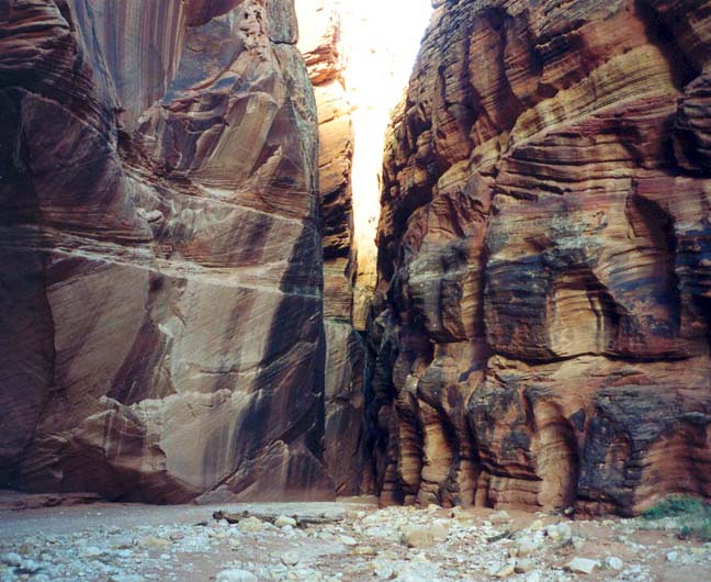
Having completed the formalities at the Wire Pass Trailhead registry across the road from the parking area (37o1.19'N 112o1.48'W), you begin hiking down the broad wash of the Buckskin tributary known as Wire Pass. Here there is little indication of the narrowness ahead as the wash meanders back and forth in a shallow valley. Around you are the typical red rocks and sparse vegetation of this high desert country. After 0.5mi or 10min you will pass the trail that climbs out of the wash on the right bound for the Coyote Buttes. But continuing down the wash, about 1mi and 30min from the start you enter the first of two sections of slot canyon in Wire Pass. The streambed narrows to about 4ft with walls climbing as you go. A short way into the slot you encounter a boulder jam with a 6ft downclimb and several more like this follow. Ominously you will note the logs jammed high overhead. But it does not take long to transit Wire Pass and, 1.7mi and 40min from the start at an elevation of 4700ft, the slot broadens abruptly and you arrive at the confluence of Wire Pass and Buckskin Gulch (37o1.34'N 112o0.85'W). These confluences are grand, cathedral-like places with towering walls on all sides. To your right as you leave Wire Pass, there is a large partial arch in the canyon wall and, just beyond this you will find some Indian pictographs etched on the wall about head high.
 | 
| |
|---|---|---|
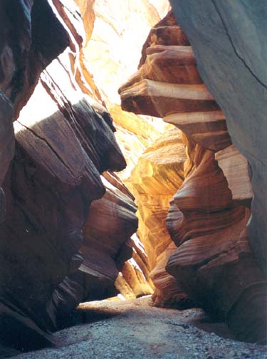
| Wire Pass from the Buckskin confluence | Midway down Buckskin Gulch |
As you start down Buckskin Gulch, the streambed narrows again and there is a long section of moderately deep narrows. The going is easy on the flat, sandy bottom. At one point there is a whole array of logs jammed between the walls high above you. Then, about 30min from the Wire Pass junction, the canyon suddenly broadens as it turns left and you find yourself in bright sunlight in a grand, red-walled canyon. Here there are large high benches, first on the right and then on the left. These could be used as a camping place or a refuge if flash floods threatened. Indeed there are many such benches in the wider sections of Buckskin Gulch though almost none of them allow one to climb out of the canyon.
About 20min later and 1hr 30min from the start, the Gulch narrows again and you enter an extended section of slot canyon with only a few short wider areas. Some distance into this section, there is a peculiar knobbly rockhead on the left, and just beyond this you encounter a rockfall where you will need to scramble over and around boulders that have yet to be ground down by the flash floods. Beyond this I first began to encounter dried up mud pools. Though easily bypassed these were evidence of wetter passage to come. This is a long section with many beautiful, sculpted rock walls that shine orange and brown where the sun penetrates.
Roughly 3hr from the start, I encountered the first pools of water to the side and, shortly thereafter, in a section only 3ft wide, the first slot-spanning pool that had to be waded. In this narrow and dark section, there were a succession of about 12 quite short, muddy pools up to about 3ft deep. A walking stick was useful here to gauge the water depth and to determine the shallowest passage. After about 20min the Gulch widened again and the last of the wading pools was passed. We note that the depth and number of pools can vary greatly from year to year.
The canyon broadens again just downstream of this series of pools and here there appears to be a climbing route out of the Gulch on the left or northern side at 37o1.88'N 111o55.28'W. It is a ledge or slot on the left wall, inclined back upstream so that you cannot see it without turning around. It would be a steep and exposed climb but not too difficult. It was marked by a large cairn in the gully bottom. This escape route is just about 6mi from the end of Wire Pass and about 8.6mi or 3hr 40min from the trailhead. Downstream of here the canyon is relatively broad and, 20min beyond the escape route, you pass a place where there are large earthslopes with vegetation on both sides. The going is open and easy here and I was struck by the number and variety of animal tracks in the sand. Mule deer, cougar, bobcat, coyote and raccoon all seemed to have passed this way quite recently; they must know more ways in and out of the Gulch than we do. Presumably they seek the water in the canyon bottom. Near where this broad section begins to narrow, someone has recorded the "13 Mile" mark (37o0.94'N 111o53.97'W) by laying the letters out with rocks on the left side. It actually represents 10mi from the Wire Pass Trialhead, almost exactly the midway point of this hike.
 | 
| |
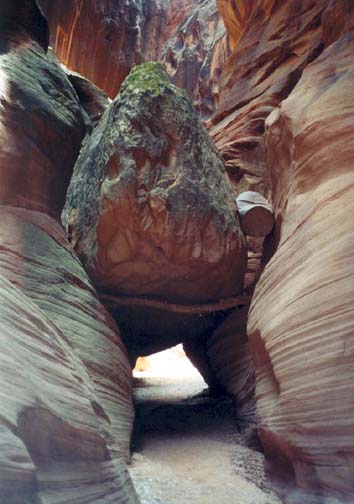
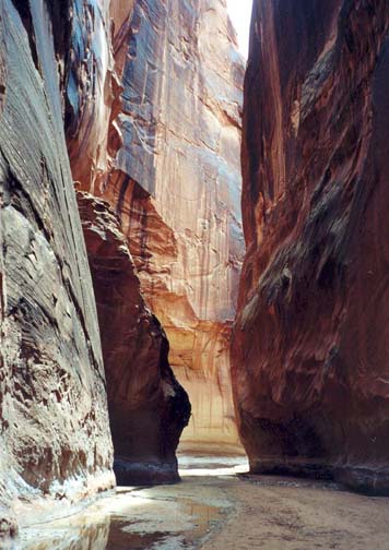
|---|---|---|
| Just below the boulder jam | In Paria Canyon |
Then, 5hr and 10mi from the start, you enter another narrow and dark section, sometimes just a couple of feet wide. At a place about 20min into this section where the canyon broadens slightly, you encounter another rockfall and here the large fallen boulders have created the only climbing challenge in the entire canyon, 11.3mi from the trailhead at 37o0.84'N 111o52.64'W. The drop on the far side of the boulders is only about 12ft and a large tree stump wedged between two of the boulders provides a good rope anchor. A 30ft length of rope is sufficient to descend. Loop it around the stump and use the doubled rope and the logs propped against the rock to downclimb the obstacle. Several old ropes have been left in place here but you should not trust them. A short distance down canyon from the boulder jam, the floor of the slot changes from dry sand to moist, presumably due to accumulating seepage. A few minutes later a trickle of a stream appears. It is very interesting to observe how this added humidity has affected the environment of the slot. The walls change color from orange and brown to beautiful blue, red, black, and green hues and stains. The moisture in the sand also makes it firmer to walk on.
For those overnighting, the first day's journey is almost done for the camping places upstream of the Buckskin/Paria confluence are a short distance ahead. The canyon broadens and on both sides of a large meander are large, wooded benches that clearly have excellent camping spots (37o0.16'N 111o52.11'W). There are no signs indicating these camping areas but they are easily identified. Only the scarcity of water could be a problem. On a day hike I reached this point 12.8mi and 6hr 10min from the start.
Downstream of the campsites, the canyon narrows again to a simple flat, moist sandy bottom with towering vertical sandstone walls on either side, a very elemental and majestic place here in the depth of the wilderness. Then, 300yds below the campsites and 13mi from the start, you finally arrive at the confluence of Buckskin Gulch with the Paria River (37o0.10'N 111o51.95'W) at an elevation of 4100ft. The Paria River whose water is yellow in contrast to the red mud of Buckskin, comes in somewhat inconspicously on the left. Almost precisely on the Utah/Arizona border, this confluence is a great cathedral of a place, a 500ft gorge in the Navajo sandstone. It is inspiring to sit here in the soft sand and enjoy the silence and the remoteness. This is also the end of a marvellous transit of Buckskin Gulch; the rest of the way lies up the canyon of the Paria River.
The Paria River drains a large section of this Utah/Arizona wilderness, flowing southeast to eventually join the Colorado River at Lees Ferry. Mormon settler John D. Lee was probably the first Anglo-American to travel down the length of Paria Canyon and subsequently established his ferry and outpost at its terminus. But, as evidenced by the many pictographs and other artifacts in these canyons, the Anasazi and other Native Americans travelled these canyons many centuries before Lee. Today another very popular multiday hike follows the Paria from our destination at the White House trailhead all the way down to Lees Ferry.
After lunch, I left the confluence and started up the Paria about
6hr 40min after the morning start. Though broader, Paria Canyon has
similar
towering walls and perhaps a little more water than Buckskin, but this
dried up about 100yds above the confluence. All the way up Paria
Canyon, the going is
fast and easy though you are very gently climbing.
About a mile from the Buckskin junction, you will encounter
Slide Rock Arch
(37o0.40'N 111o51.96'W),
where a huge block of sandstone has broken off the
right wall and plunged to the canyon bed, coming to rest with the top
leaning against the canyon wall and thus forming an
arch. The floods are however gradually eating away at the base of
the great boulder and will eventually cause it to fall.
Beyond the arch, the
narrows gradually widen and the walls decrease in height as you proceed
upstream. About 5mi up the Paria (and with 2mi yet to go)
you pass under
power lines and by this point you are travelling in a broad floodplain.
Finally, within few hundred yards of the White House trailhead,
you emerge from the Navajo sandstone onto an even wider floodplain. Off
to the right you will see rock bluffs with
marvellous red and white striations. The White House trailhead
(37o4.72'N 111o53.40'W) is
just under these and a small trail marker on the right bank of the
streambed indicates the way up to the campground and the White House
parking area. The hike from the confluence to this trailhead is readily
accomplished in three hours. The complete dayhike will take about
9.5hr during which you will travel 20.2mi.
Last updated 7/1/01.
Christopher E. Brennen