ADVENTURE HIKES AND CANYONEERING
IN THE SOUTHWEST
© Christopher Earls Brennen

|
|---|

|
Hike B2. Blarney Canyon
- Hiking time: 3.5 hours
- Estimated hiking distance: 2.2 miles
- Elevation gain: 340 feet
- USGS Topo Map: Turkey Knob
- Difficulties: 3 rappels up to 40ft, narrow slots as small as 15in and many downclimbs
- Special equipment: 80 feet rope, 40 feet webbing, 3 rappel rings, full rappelling gear, gloves and protection for knees and elbows
-
ACA Rating: 3B II

Characteristics
The southeastern corner of Utah is a scorched wilderness of sandstone rock, crevassed by the movement of the earth, wind and water and baked by the searing summer sun. Not much lives here: a few hardy shrubs and small animals capable of finding coolness deep within the ground. Some pioneers survived their travels through this land; virtually none stayed for it was not possible to live here. When the Glen Canyon Dam was completed, Lake Powell flooded a spidery maze of canyons and men came by boat to enjoy the beauty of the rock and the water. Roads were cut and paved to allow access to marinas within this network and the beauty of the wilderness surrounding Lake Powell began to be appreciated and enjoyed.
It is a landscape of huge vistas with great redstone cliffs and flat mesas as far as the eye can see. The relief is dominated by the enormous canyons cut by the Colorado river. But that great river also has thousands of tributaries. Each of these has its own canyons, often extremely deep and narrow because of the special way in which the storm water runs off this bare land and cuts deep slots through the slickrock. And so for a huge area, this land is riven through with narrow slot canyons, places of special beauty and adventure. In this collection, we describe descents through several of the slots accessible from Utah Highway 95, the road that runs from Hanksville down to the Hite crossing of the Colorado. Just past the junction of Highway 95 with Highway 276 there is a group of readily accessible slot canyons on the north side of the road that are called the ``Irish Canyons''. These run down into the North Wash, the streambed that the road follows. These canyons include Shillelagh, Blarney and Leprechaun Canyons. Each of these have several forks. Here we describe a descent of of the Left Fork of Blarney Canyon.
Like the other Irish canyons, Blarney is very narrow in places, sometimes no more than 1ft in width. Consequently it is not for those with a heavy build nor for those who suffer from claustrophobia. Though the hike is quite short, squeezing through this defile can be both exhausting and very hard on clothing. Wear old clothes and cover your elbows and knees otherwise you will leave skin in the canyon. Blarney Canyon requires three short rappels and much downclimbing with chimneying, stemming and body-jamming.
The hike is best undertaken in the spring or fall in order to avoid the 100 degree plus heat of the summer (though it is much cooler in the slots). However, the danger of flash floods is extreme and so you should keep a sharp eye out for thunderstorms, particularly late in the day. Even in summer, there may be foot deep pools to wade so be prepared for wet feet.
Note that the approach hike described below is also the approach for the neighboring canyon to the northwest, known as Shillelagh Canyon (pronounced ``Shill-ay-lee''). Shillelagh is also an excellent canyoneering venture. In Ireland blarney means talk/chat/stories while a shillelagh is a club/weapon/walking stick cut from a blackthorn bush; we chose Blarney ``because talk is better than war''.
Trailhead
The trailhead for Blarney Canyon (38o1.27'N 110o32.90'W) is a short dirt road spur on the northeast side of Highway UT 95 just southeast of the junction of Highway UT 276 and Highway UT 95 roughly 26mi southeast of Hanksville, Utah. Drive southeast down Highway UT 95 from that junction to milepost 27.6 and look for the short dirt spur on your left. Drive about 50yds and park in the shade under the slickrock bluff.
Hike
From the dirt turnout (elevation 4520ft) you will see Blarney Canyon immediately on your left and defined on the other side of the narrow wash by a slickrock nose. Hike across Blarney Wash to that nose and begin to ascend the ridge, staying close its apex. As you climb Blarney is the canyon on your right; the canyon on your left is Shillelagh Canyon.
 | 
| |
|---|---|---|
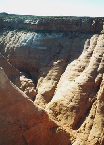
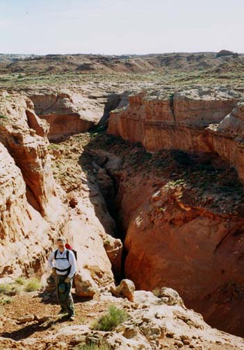
| Looking down into Blarney Canyon | View into head of Blarney Canyon |
The hike up the apex of the slickrock ridge is easy but steep. As you near the top go left around a cap rock bluff and then follow the use-trail up onto the mesa top. Here you will get a fine view of Blarney Canyon on your right with its Left and Right Forks (there is a short additional fork closer to you) and Shillelagh Canyon on your left. The use-trail on the mesa is quite evident and about 30min from the start at an elevation of 4860ft it proceeds across a narrow isthmus (38o1.79'N 110o32.60'W) between Blarney and Shillelagh Canyons. On the far side of the isthmus, the trail forks. The left fork goes to the head of Shillelagh Canyon. You take the right fork and proceed along close to the rim of Blarney Canyon. About 50min and 1.2mi from the start at an elevation of 4860ft, you will arrive at the head of Blarney Canyon, or rather at a small hanging fork just before the head (38o1.99'N 110o32.40'W).
 | 
| |
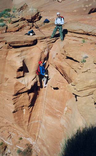
|---|---|---|
| At the first rappel | In Blarney Canyon |
The descent into the bottom of Blarney Canyon is a two step process. The first step is to find the only place which allows easy climb down into the small hanging fork; that place is around the far side of the head of the fork. A short slickrock downclimb brings you to the top of the first rappel, a 40ft vertical drop into the wide Left Fork from an anchor around a large boulder (you should be able to see this webbing from the rim above and thus confirm your location before beginning the descent).
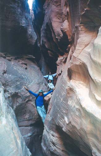
Just 50yds down canyon from the first rappel, the streambed drops into a narrow slot in the middle of the broad canyon. This requires the second rappel, a 30ft drop from a wrap around a large boulder at the head of the slot. Note that this drop can be downclimbed by accessing the slot through a hole at the back of the large boulder. Downstream of this second rappel, the slot is narrow and very interesting. At 4690ft and about 2hrs from the start, you arrive at the top of the third rappel in a narrow slot; this is a 40ft drop from a wrap around a rock into a dark and narrow defile. Just around the corner from this descent there is a neat room. From there the slot continues very narrow with many neat downclimbs frequently requiring friction jams. About 3hrs from the start at 4630ft the slot opens up and you arrive at the confluence with the Right Fork of Blarney Canyon. Continuing downstream in a broad wash you encounter one last short slot cut into the bottom of the wash. Beyond this it is an easy walk to the trailhead (38o1.27'N 110o32.90'W).
It should take about 3hrs 20min to complete the hike.
Last updated 6/20/04.
Christopher E. Brennen