ADVENTURE HIKES AND CANYONEERING
IN THE SOUTHWEST
© Christopher Earls Brennen

|
|---|

|
Hike K15. Big Falls
- Hiking time: 7 hours
- Estimated hiking distance: 6.2 miles
- Elevation gain: 1890 feet
- USGS Topo Map: Forest Falls
- Difficulties: Two large, wet and tricky rappels measuring 140ft and 100ft.
- Special equipment: Rappeling gear, harnesses, 60m rope, two rappel rings, 30ft webbing.
-
ACA Rating: 3A III

Characteristics
One of the most accessible and spectacular waterfalls in the San Bernadino Mountains is called simply Big Falls. When you leave Route 38, drive up the little spur road to Forest Falls and pass through that hamlet the waterfalls become readily visible cascading down the canyon wall on the opposite side of Mill Creek wash. If you have time it is valuable to reconnoitre the falls prior to the hike by parking at the Big Falls Trailhead at the end of the road. Hiking about 200yds back down the wash you can enter Big Falls Canyon via a short trail on the right. From the end of this trail it is a simple matter to clamber up to the base of the lower of the two big waterfalls. Big Falls consists of a series of waterfalls that, in total, drop precipitiously about 400ft down the north wall of Mill Creek Canyon. The two at the top of this series represent the major technical challenges in this adventure. They measure 140ft and 100ft respectively and are spectacular, wet and tricky rappels that are only for the experienced canyoneer.
But the waterfalls called Big Falls are not the only attraction on this adventure hike for the stream descends to them through some beautiful mountain scenery that makes the access hike a real pleasure. The slopes are forested and, in the spring and early summer, are sprinkled with abundant wildflowers. After the hike up the mountain on maintained trails to reach the creek, high above the Falls, the off-trail hike down the canyon is a real delight. The crystal-clear, year-long stream cascades down over dozens of small and moderate waterfalls surrounded by pine forest. There are some lovely places to camp if you wish to spend more than a day on this hike.
Trailhead
From Interstate 10 just east of San Bernadino take the Orange Street or Route 38 offramp. At Orange Street, turn under the freeway and drive north on Route 38. After a few blocks Route 38 turns right. You drive east through Mentone and then wind your way up past the Mill Creek Ranger Station into the valley of Mill Creek. The spur road to Forest Falls continues up Mill Creek Canyon at a place where Route 38 makes a sweeping left turn. Drive up through Forest Falls to the Big Falls trailhead at the end of the road (34o4.90'N 116o53.57'W). Leave one vehicle there and, in the other vehicle, drive back the way you came for 1.6mi to the parking area at the Momyer-Alger Creek Trailhead. Park here at 34o5.25'N 116o54.99'W and an elevation of 5500ft.
Hike
From the parking area (34o5.25'N 116o54.99'W and an elevation of 5500ft), the Momyer-Alger Creek trail (1E06) is indistinct as it crosses the Mill Creek Wash but if you head for the Wilderness Area sign on the far side you will soon pick up the maintained trail. This climbs steadily for 1790ft up to an unmarked trail junction just past a San Gorgonio Wilderness Area sign at 7290ft. You should reach this junction at 34o6.08'N 116o54.64'W about 1hr 35min and 2.2mi from the start; do not go left but continue straight on. The trail contours around the valley of Alger Creek and then descends about 200ft to Alger Creek itself where there is a small trail camp. You should reach Alger Creek (34o6.22'N 116o54.16'W and an elevation of 7050ft) about 3.2mi and 2hr from the start. Continuing on, the trail contours out onto a prominent ridge where the topo map indicates an old trail climbed up from the valley below (this trail is now overgrown). After this it climbs about 390ft to a second ridge that overlooks the valley of Big Falls creek. It is important to identify the trail junction at 34o5.62'N 116o53.53'W and an elevation of 7390ft on the apex of this ridge, 4.7mi and 2hr 50min from the start. There are signposts nailed to a tree. The main trail turns sharp left and continues up the apex of the ridge. But you follow the sign pointing to Dobbs and descend down the other side of the ridge, contouring toward the stream that you can hear below you. It takes just about 10min to reach Big Falls Creek at a beautiful spot (34o5.67'N 116o53.29'W) where two streams meet. There is a rudimentary campground here at 7200ft called Dobbs Camp. It should take a total of 3hr to cover the 4.9mi to this drop-in point.
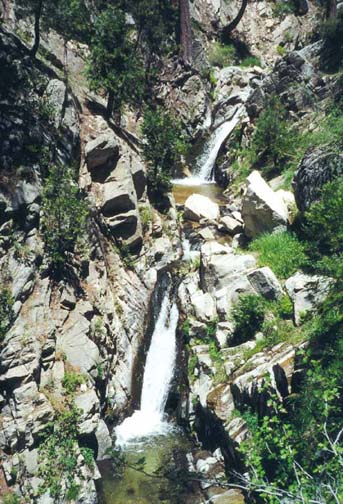
|
|---|
| Canyon above Big Falls |
The hike downstream from Dobbs Camp is one of the most beautiful in this series. The sparkling mountain stream tumbles down over dozens of waterfalls as it makes its way through pine forest and around sculpted rock outcroppings. The going is rough but it is clear that others have passed this way for, in many places, there is a rudimentary use-trail that makes passage easier. Just 15min below Dobbs Camp you encounter a narrows with two lovely waterfalls in rapid succession, with drops of about 20ft and 25ft. A use-trail climbs the left bank and bypasses these falls fairly easily. There are many more small waterfalls as you continue downstream; all can be downclimbed or bypassed. About a hour downstream at 6700ft there is a substantial, ad hoc campsite in the trees on the left bank; other smaller campsites occur between here and the falls.
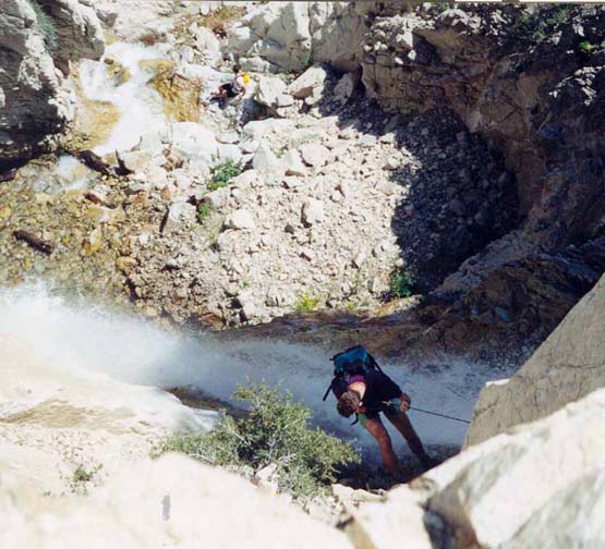 | 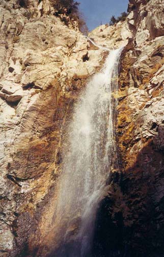
| |
|---|---|---|
| Descending the upper falls | The lower of the two big waterfalls |
After about 2hr of hiking down the creek, you glimpse a dramatic exposure ahead and, quite suddenly, you arrive at the breath-taking top of Big Falls. (You should reach this point at 34o5.17'N 116o53.73'W and an elevation of 6380ft about 5.8mi and 5hr 30min from the start.) As you peer through the rock gate at the top of the falls, all you can see are huge, bright ochre cliffs dropping down far below you. Further away, Mill Creek and the road to the trailhead are plainly visible. But because the uppermost waterfall proceeds down a short chute before going into freefall, you cannot easily make out where it bottoms out. To reconnoitre the situation, there is a narrow, exposed shelf about 10ft above the left side of the lip. On a belay you should make your way along this shelf to a small platform and a prominent rock horn. Peering over the horn you can get a good view of the descent and, about 140ft below you, the platform you will descend to.
The best anchor for this single rappel is a convenient tree on the right side of the lip where you should place the webbing high in the tree in order to ease rope recovery. Though there are other, larger trees in the center, this anchor location allows you to descend skirting the right side of the stream for about 30ft, and then transition onto the vertical face to the right of the falls. The footing is slippery for most of the way so care is needed and, as always, a helmet is recommended. The descent ends on a large rock covered platform that narrows on the downstream side to the lip of the second stage of Big Falls.
Since many folk clamber up to the base of the lower of the two big waterfalls you are likely to have an audience for this second rappel, a 100ft vertical drop into a rock-walled chasm with a rocky bottom. There are several large boulders on the right side of the intermediate platform that can serve as excellent anchors. Note, especially, that if you use one of the big boulders lower down on the right side of the platform, a double rappel with a 60m rope will get you to the bottom with only a few feet of rope to spare. Rappel down the right side of the waterfall. If you go straight down you will be soaked in the mainstream of the falls; but you can avoid the worst of this maelstrom by using a dihedral to veer further right. You should reach the bottom of this second and last rappel about 6hr 45min after starting out.
From the bottom of the big waterfalls, follow the well-worn use-trail on the right side. This bypasses several smaller waterfalls, crosses to the left side and connects with the short maintained trail that takes you to the end of Big Falls Canyon where it emerges to join Mill Creek. At the exit, turn left and follow the wash upstream for several hundred yards. Crossing Mill Creek you will easily locate the Big Falls Trailhead parking lot (34o4.90'N 116o53.57'W) where you left the return vehicle.
Last updated 6/9/01.
Christopher E. Brennen