ADVENTURE HIKES AND CANYONEERING
IN THE SOUTHWEST
© Christopher Earls Brennen

|
|---|

|
Hike L2. Point Bennett, San Miguel Island
- Hiking time: 6 hours in a 4 day expedition
- Estimated hiking distance: 13.8 miles
- Elevation gain: about 1500 feet total
- USGS Topo Map: San Miguel Island East, San Miguel Island West
- Difficulties: Access; hike must be accompanied by a ranger
- Special equipment: Binoculars
Characteristics
San Miguel is the westernmost of the Channel Islands and part of the Channel Islands National Park in the Santa Barbara channel. It is a remote and wild place where you can only hike if guided by the Park Ranger. Three hikes on San Miguel are listed in this collection and, though guided, qualify as adventure hikes because of the unique destinations and the adventure involved in getting to the island and camping there.
The island consists of a relative flat plateau ringed by coastal bluffs and cliffs. Until about 40 years ago, the island had been almost denuded of vegetation by the sheep that were raised on the island. The result was that much of the island was covered in driven sand blown in by the prevailing northwest winds. In the intervening 40 years much of the island has recovered some vegetation though there are still some sand-blown areas. There are, however, almost no trees and the island is largely covered by grass and low bushes. Unlike the neighbouring islands to the east, San Miguel is not sheltered from the northwest winds by Point Conception and the mainland. Consequently the weather is rather different, being either foggy or windy.
The principal attractions on San Miguel are the amazing spectacles of tens of thousands of seals resting, birthing and breeding on the beaches of the island. This hike to Point Bennett, the extreme western end of the island, involves a long 14mi round trip hike but one that is rewarded by the amazing spectacle of huge numbers of pinnipeds (seals, sea lions, etc.) basking on the long beaches that make up the point.
Trailhead
A concessionaire, Islandpackers, runs ferries to all four of the islands of the Santa Barbara channel, which, reading from east to west, are Anacapa, Santa Cruz, Santa Rosa and San Miguel. Their headquarters and principal port of embarkation are a jetty next to the visitors center at Ventura Harbor. They operate roughly 10 visits a year to San Miguel with, typically, an outbound trip on Friday and the return journey on Monday. The ferry usually makes stops at Santa Cruz and Santa Rosa on the way to San Miguel and it therefore takes about 5hrs to get to San Miguel. There are no accommodations on the island other than the campground so one must come prepared for rough camping for two or three nights. Because of the wind and fog, camping is rather more challenging than usual in Southern California. The lone campground has sites that are equipped with windbreaks (as well as food-boxes and tables). Moreover, there is no water available so that campers must bring their own from the mainland. Camping reservations must be made with the National Park before booking passage to the island.
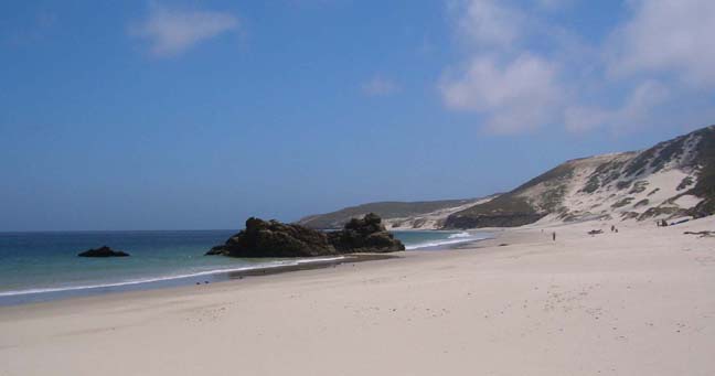
|
|---|
| Cuyler Harbor beach |
Unlike the other islands, there is no jetty at San Miguel and the landing is an adventure in itself. The ferry anchors in the sheltered bay called Cuyler Harbor and then, aboard a Zodiac, passengers are ferried, six at a time, through the surf to the pristine beach that lines the bay (34o2.83'N 120o21.06'W). Packs and other camping gear (including water) are similarly landed. Don't be surprised if a group of elephant seals are sunning themselves on the beach beside where you land!
From the beach, a steep trail ascends the coastal bluffs by climbing up the side of Nidever Canyon just inland of the landing point. Climbing out of the canyon onto the island plateau the trail heads east to a small saddle where the campground is located, at 34o2.45'N 120o20.95'W), an elevation of 490ft and 0.7mi from the beach.
Hike
The ranger-led hike to Point Bennett usually begins about 9am when the ranger meets you in the campground. The current ranger (2005) is the friendly Ian Williams. After a brief stop at the Lester Ranch House site about 100yds from the campground you proceed up to the airstrip and past the ranger station (34o2.36'N 120o21.01'W) to the gently sloping trail up San Miguel Hill. In the spring this slope is a riot of wildflowers among the grass. After 45min of hiking you reach the 831ft summit of San Miguel Hill (34o1.98'N 120o21.87'W) and its weather station structure about 1.1mi from camp. Descending into the shallow valley on the far side you will come to a turn-off (34o1.99'N 120o22.34'W) to the Caliche Forest; take this excursion by forking right and hiking about 300yds to the edge of the Caliche Forest, the calcified remains of an ancient forest.
Returning to the main trail you descend further, cross South Green Mountain Canyon and then turn north, hiking up a ridge to the shoulder of Green Mountain. Your highpoint on this shoulder is at 34o2.23'N 120o23.11'W and an elevation of 720ft, 3.1mi and 1hr 40min of hiking from the campground. From this highpoint you can see Point Bennett, the end of the island in the distance. Beyond this point the groundcover is mostly grass with a few low bushes.
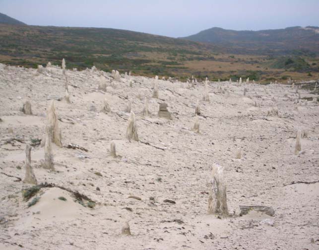 | 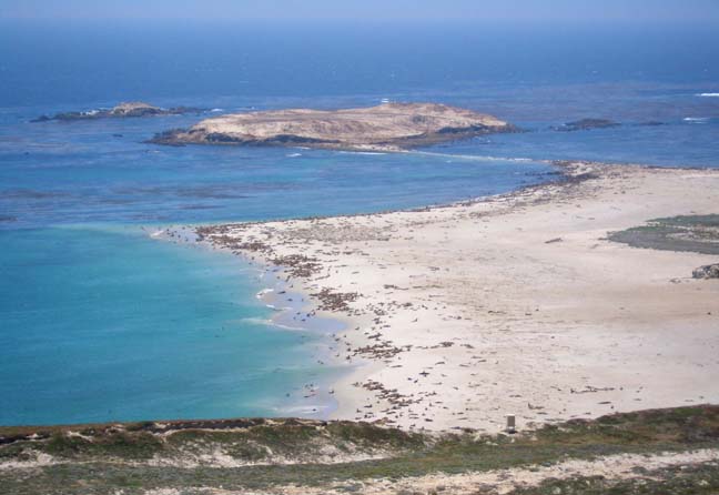
| |
|---|---|---|
| Caliche forest | Point Bennett |
From the Green Mountain shoulder, the trail descends gently following the route of a dirt road bulldozed out by the US Navy when they occupied the island and known as the ``Road to Mandalay''. Ascending a small rise it eventually reaches Dry Lake (34o2.52'N 120o24.73'W and elevation 380ft) where a dirt airstrip is maintained to service the Research Station at Point Bennett. Very occasionally Dry Lake actually fills with run-off to a depth of one or two feet. Dry Lake is 5mi from camp including the Caliche Forest diversion; it takes about 2.5hrs of hiking to reach this point.
West of Dry Lake the landscape becomes increasing sandy and, after another mile you crest a small rise to get the first, amazement-filling view of Point Bennett and the tens of thousands of seals hauled out on its beaches. Descending about 200yds and veering right you arrive at the wooden cabin of the Point Bennett Research Station (34o1.95'N 120o25.67'W and elevation 260ft). The Research Station is reached after 6.1mi and 3hrs of hiking though the various Ranger presentations at the Lester Ranch, San Miguel Hill, Caliche Forest, Green Mountain and Dry Lake add an additional hour to the total elapsed time. About 100yds beyond the Research Station is a clifftop observation point which makes a fine lunch stop.
From the Research Station the trail veers northwest to access a ridge by which one can descend the bluffs and then turns south to end just behind the last dune before the beach (34o1.96'N 120o26.35'W). This is as close as one can get to the seals and sea-lions that densely pack the long beaches. Especially with a pair of binoculars, one has an excellent view from behind this dune while the animals are not disturbed as long as they do not see standing human figures. You should reach this point 7.2mi and 3hrs 20min of hiking from the campground.
Aside from the sheer numbers of animals on these beaches, this pinniped (fin-footed marine mammals) rookery at Point Bennett is remarkable, indeed unique, in other ways and has been called the ``California Galapagos'' with some justification. Five different species of seals gather here regularly while a sixth is an occasional visitor. This is the greatest variety to be found in any one location anywhere in the world. The five regulars are the harbor seal, the California sea lion, the elephant seal, the northern fur seal, and the Steller sea lion while the Guadalupe fur seal is an occasional visitor. Three of these species mate and birth on the beaches while the others haul out to rest. In addition sea otters are increasingly frequent inhabitants of the surrounding kelp beds. It is a spectacular and amazing place especially considering its proximity to the huge metropolis just 100mi to the east.
It not easy to leave this remarkable place, but one must return to the
campground
(34o2.45'N 120o20.95'W)
before dark. The 6.6mi return hike takes about
2.5hrs.
Last updated 6/1/05.
Christopher E. Brennen