ADVENTURE HIKES AND CANYONEERING
IN THE SOUTHWEST
© Christopher Earls Brennen

|
|---|

|
Hike K14. Alger Creek
- Hiking time: 4 hours
- Estimated hiking distance: 4.8 miles
- Elevation gain: 1890 feet
- USGS Topo Map: Forest Falls
- Difficulties: None
- Special equipment: None
-
ACA Rating: 1A II

Characteristics
Some of the most accessible adventure hikes in the San Bernadino Mountains can be found along the steep sides of Mill Creek near Forest Falls in southern California. These are beautiful wooded slopes of pine and cedar with lovely crystal streams and panoramic views. The Momyer-Alger Creek Trail switchbacks up the steep northern wall of Mill Creek Canyon. In this adventure, you will hike up this trail, climbing 1900ft to a place where it crosses Alger Creek. From there you follow the creek back down to Mill Creek wash, descending a boulder-strewn canyon bottom that does not involve any rappels or technical challenges. This is a good starter hike for those would are unaccustomed to off-trail hiking or technical rappeling. It could be undertaken anytime during the year but is best in the late spring, summer or early fall.
Trailhead
From Interstate 10 just east of San Bernadino take the Orange Street or Route 38 offramp. At Orange Street, turn under the freeway and drive north on Route 38. After a few blocks Route 38 turns right. You drive east through Mentone and then wind your way up past the Mill Creek Ranger Station into the valley of Mill Creek. The spur road to Forest Falls continues up Mill Creek Canyon at a place where Route 38 makes a sweeping left turn. Drive up toward Forest Falls to the Momyer-Alger Creek trailhead which is well-signposted on the left side of the road about 0.15mi after the Fallsvale school and before the center of Forest Falls. Park here at 34o5.25'N 116o54.99'W and an elevation of 5500ft.
Hike
From the parking area (34o5.25'N 116o54.99'W and an elevation of 5500ft), the Momyer-Alger Creek trail (1E06) is indistinct as it crosses the Mill Creek Wash but if you head for the Wilderness Area sign on the far side you will soon pick up the maintained trail. This climbs steadily for 1790ft up to an unmarked trail junction just past a San Gorgonio Wilderness Area sign at 7290ft. You should reach this junction at 34o6.08'N 116o54.64'W about 1hr 35min and 2.2mi from the start; do not go left but continue straight on. The trail contours around the valley of Alger Creek and then descends about 200ft to Alger Creek itself where there is a small trail camp. You should reach Alger Creek (34o6.22'N 116o54.16'W and an elevation of 7050ft) about 3.2mi and 2hr from the start.
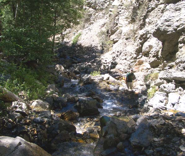
|
|---|
| Typical Alger Creek conditions |
The initial canyon descent is gradual in a pretty, wooded canyon. There is a faint
use=trail that begins on canyon right but soon switches to the left side for
and extended distance. About 50min from the Alger Creek trailcamp at
about 6400ft the canyon has a left-right kink and begins to descend
more steeply over jumbled rocks and rockfalls. This continues until an
elevation of about 5750ft when the canyon bottom flattens into a wash.
It is an easy hike down this wash and across Mill Creek to the trailhead where
you left your vehicle
at 34o5.25'N 116o54.99'W and an elevation
of 5500ft. You should complete this 4.8mi hike in about
4hrs.
Christopher E. Brennen